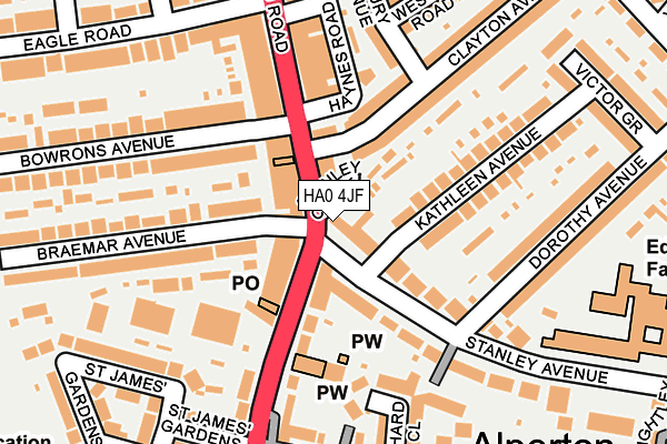
HA0 4JF is located in the Wembley Central electoral ward, within the London borough of Brent and the English Parliamentary constituency of Brent North. The Sub Integrated Care Board (ICB) Location is NHS North West London ICB - W2U3Z and the police force is Metropolitan Police. This postcode has been in use since January 1980.


GetTheData
Source: OS OpenMap – Local (Ordnance Survey)
Source: OS VectorMap District (Ordnance Survey)
Licence: Open Government Licence (requires attribution)
| Easting | 518218 |
| Northing | 184192 |
| Latitude | 51.544251 |
| Longitude | -0.296619 |
GetTheData
Source: Open Postcode Geo
Licence: Open Government Licence
| Country | England |
| Postcode District | HA0 |
| ➜ HA0 open data dashboard ➜ See where HA0 is on a map ➜ Where is London? | |
GetTheData
Source: Land Registry Price Paid Data
Licence: Open Government Licence
Elevation or altitude of HA0 4JF as distance above sea level:
| Metres | Feet | |
|---|---|---|
| Elevation | 40m | 131ft |
Elevation is measured from the approximate centre of the postcode, to the nearest point on an OS contour line from OS Terrain 50, which has contour spacing of ten vertical metres.
➜ How high above sea level am I? Find the elevation of your current position using your device's GPS.
GetTheData
Source: Open Postcode Elevation
Licence: Open Government Licence
| Ward | Wembley Central |
| Constituency | Brent North |
GetTheData
Source: ONS Postcode Database
Licence: Open Government Licence
| January 2024 | Vehicle crime | On or near Stanley Avenue | 209m |
| January 2024 | Vehicle crime | On or near Bridgeway | 401m |
| January 2024 | Anti-social behaviour | On or near Rosemont Road | 494m |
| ➜ Get more crime data in our Crime section | |||
GetTheData
Source: data.police.uk
Licence: Open Government Licence
| Clayton Avenue (Ealing Road) | Alperton | 52m |
| Stanley Avenue Ealing Road (Ealing Road) | Alperton | 87m |
| Eagle Road | Wembley | 260m |
| Mount Pleasant | Alperton | 269m |
| Mount Pleasant | Alperton | 273m |
| Alperton Underground Station | Alperton | 454m |
| Wembley Central Underground Station | Wembley | 896m |
| Stonebridge Park Underground Station | Stonebridge Park | 1,438m |
| Sudbury Town Underground Station | Sudbury Town | 1,514m |
| Wembley Central Station | 0.9km |
| Wembley Stadium Station | 1.4km |
| Stonebridge Park Station | 1.4km |
GetTheData
Source: NaPTAN
Licence: Open Government Licence
GetTheData
Source: ONS Postcode Database
Licence: Open Government Licence


➜ Get more ratings from the Food Standards Agency
GetTheData
Source: Food Standards Agency
Licence: FSA terms & conditions
| Last Collection | |||
|---|---|---|---|
| Location | Mon-Fri | Sat | Distance |
| Alperton Post Office | 18:15 | 12:15 | 56m |
| Eagle Road | 17:00 | 12:15 | 201m |
| Woodside Avenue | 17:45 | 12:45 | 268m |
GetTheData
Source: Dracos
Licence: Creative Commons Attribution-ShareAlike
| Facility | Distance |
|---|---|
| Alperton Community School (Upper Site) Stanley Avenue, Wembley Sports Hall | 261m |
| Alperton Community School (Lower Site) Ealing Road, Wembley Sports Hall, Artificial Grass Pitch | 393m |
| The Gym Group (Alperton) Ealing Road, Wembley Health and Fitness Gym | 400m |
GetTheData
Source: Active Places
Licence: Open Government Licence
| School | Phase of Education | Distance |
|---|---|---|
| The Corner School Douglas Avenue, Wembley, Middlesex, HA0 4DT | Not applicable | 272m |
| Alperton Community School Stanley Avenue, Wembley, HA0 4JE | Secondary | 289m |
| Lyon Park Primary School Vincent Road, Wembley, HA0 4HH | Primary | 609m |
GetTheData
Source: Edubase
Licence: Open Government Licence
The below table lists the International Territorial Level (ITL) codes (formerly Nomenclature of Territorial Units for Statistics (NUTS) codes) and Local Administrative Units (LAU) codes for HA0 4JF:
| ITL 1 Code | Name |
|---|---|
| TLI | London |
| ITL 2 Code | Name |
| TLI7 | Outer London - West and North West |
| ITL 3 Code | Name |
| TLI72 | Brent |
| LAU 1 Code | Name |
| E09000005 | Brent |
GetTheData
Source: ONS Postcode Directory
Licence: Open Government Licence
The below table lists the Census Output Area (OA), Lower Layer Super Output Area (LSOA), and Middle Layer Super Output Area (MSOA) for HA0 4JF:
| Code | Name | |
|---|---|---|
| OA | E00002336 | |
| LSOA | E01000473 | Brent 029B |
| MSOA | E02000121 | Brent 029 |
GetTheData
Source: ONS Postcode Directory
Licence: Open Government Licence
| HA0 4BX | Stanley Close | 25m |
| HA0 4JA | Stanley Avenue | 29m |
| HA0 4QG | Ealing Road | 59m |
| HA0 4BY | Ealing Road | 91m |
| HA0 4QL | Ealing Road | 96m |
| HA0 4JU | Clayton Avenue | 103m |
| HA0 4JQ | Stanley Avenue | 108m |
| HA0 4JH | Kathleen Avenue | 143m |
| HA0 4QD | Ealing Road | 156m |
| HA0 4QW | Braemar Avenue | 175m |
GetTheData
Source: Open Postcode Geo; Land Registry Price Paid Data
Licence: Open Government Licence