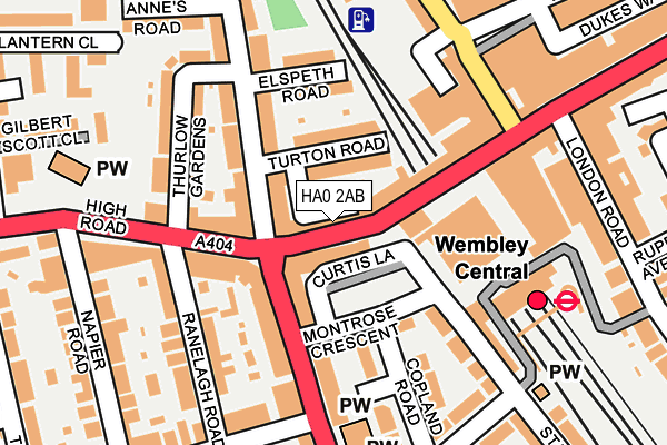
HA0 2AB is located in the Wembley Central electoral ward, within the London borough of Brent and the English Parliamentary constituency of Brent North. The Sub Integrated Care Board (ICB) Location is NHS North West London ICB - W2U3Z and the police force is Metropolitan Police. This postcode has been in use since January 1980.


GetTheData
Source: OS OpenMap – Local (Ordnance Survey)
Source: OS VectorMap District (Ordnance Survey)
Licence: Open Government Licence (requires attribution)
| Easting | 518088 |
| Northing | 185073 |
| Latitude | 51.552196 |
| Longitude | -0.298197 |
GetTheData
Source: Open Postcode Geo
Licence: Open Government Licence
| Country | England |
| Postcode District | HA0 |
| ➜ HA0 open data dashboard ➜ See where HA0 is on a map ➜ Where is Wembley? | |
GetTheData
Source: Land Registry Price Paid Data
Licence: Open Government Licence
Elevation or altitude of HA0 2AB as distance above sea level:
| Metres | Feet | |
|---|---|---|
| Elevation | 40m | 131ft |
Elevation is measured from the approximate centre of the postcode, to the nearest point on an OS contour line from OS Terrain 50, which has contour spacing of ten vertical metres.
➜ How high above sea level am I? Find the elevation of your current position using your device's GPS.
GetTheData
Source: Open Postcode Elevation
Licence: Open Government Licence
| Ward | Wembley Central |
| Constituency | Brent North |
GetTheData
Source: ONS Postcode Database
Licence: Open Government Licence
| January 2024 | Anti-social behaviour | On or near Elm Road | 301m |
| January 2024 | Drugs | On or near Elm Road | 301m |
| January 2024 | Other theft | On or near Elm Road | 301m |
| ➜ Get more crime data in our Crime section | |||
GetTheData
Source: data.police.uk
Licence: Open Government Licence
| Wembley Central Station (High Road) | Wembley Central | 19m |
| Wembley Central Station (High Road) | Wembley Central | 28m |
| Wembley Central Station (High Road) | Wembley Central | 52m |
| High Road Wembley (Ealing Road) | Wembley | 87m |
| Wembley Central Station | Wembley Central | 99m |
| Wembley Central Underground Station | Wembley | 94m |
| North Wembley Underground Station | North Wembley | 1,220m |
| Sudbury Town Underground Station | Sudbury Town | 1,227m |
| Alperton Underground Station | Alperton | 1,291m |
| Wembley Park Underground Station | Wembley Park | 1,795m |
| Wembley Central Station | 0.1km |
| Wembley Stadium Station | 0.9km |
| Sudbury & Harrow Road Station | 1.2km |
GetTheData
Source: NaPTAN
Licence: Open Government Licence
GetTheData
Source: ONS Postcode Database
Licence: Open Government Licence


➜ Get more ratings from the Food Standards Agency
GetTheData
Source: Food Standards Agency
Licence: FSA terms & conditions
| Last Collection | |||
|---|---|---|---|
| Location | Mon-Fri | Sat | Distance |
| Wembley Central Station | 18:30 | 12:30 | 55m |
| 508 High Road | 18:30 | 12:00 | 134m |
| Lancelot Road | 17:00 | 12:00 | 264m |
GetTheData
Source: Dracos
Licence: Creative Commons Attribution-ShareAlike
| Facility | Distance |
|---|---|
| The Gym Group (London Wembley Central) Central Square, Wembley Health and Fitness Gym | 140m |
| Puregym (London Wembley) High Road, Wembley Health and Fitness Gym | 233m |
| King Edward Vii Park Park Lane, Wembley Grass Pitches, Outdoor Tennis Courts | 549m |
GetTheData
Source: Active Places
Licence: Open Government Licence
| School | Phase of Education | Distance |
|---|---|---|
| Ark Elvin Academy Cecil Avenue, Wembley, Middlesex, London, HA9 7DU | Secondary | 500m |
| Park Lane Primary School Park Lane, Wembley, HA9 7RY | Primary | 503m |
| New Level Academy Pendolino Way, Wembley, London, NW10 0RP | Not applicable | 601m |
GetTheData
Source: Edubase
Licence: Open Government Licence
The below table lists the International Territorial Level (ITL) codes (formerly Nomenclature of Territorial Units for Statistics (NUTS) codes) and Local Administrative Units (LAU) codes for HA0 2AB:
| ITL 1 Code | Name |
|---|---|
| TLI | London |
| ITL 2 Code | Name |
| TLI7 | Outer London - West and North West |
| ITL 3 Code | Name |
| TLI72 | Brent |
| LAU 1 Code | Name |
| E09000005 | Brent |
GetTheData
Source: ONS Postcode Directory
Licence: Open Government Licence
The below table lists the Census Output Area (OA), Lower Layer Super Output Area (LSOA), and Middle Layer Super Output Area (MSOA) for HA0 2AB:
| Code | Name | |
|---|---|---|
| OA | E00003051 | |
| LSOA | E01000633 | Brent 019D |
| MSOA | E02000111 | Brent 019 |
GetTheData
Source: ONS Postcode Directory
Licence: Open Government Licence
| HA0 2AA | High Road | 11m |
| HA0 2BS | Turton Road | 53m |
| HA0 4AA | Ealing Road | 72m |
| HA0 4AH | Station Grove | 73m |
| HA0 4YB | Montrose Crescent | 83m |
| HA0 2AJ | Lancelot Parade | 90m |
| HA0 2AF | High Road | 112m |
| HA0 4YS | Montrose Crescent | 112m |
| HA9 7BS | High Road | 112m |
| HA0 2BP | Lancelot Road | 113m |
GetTheData
Source: Open Postcode Geo; Land Registry Price Paid Data
Licence: Open Government Licence