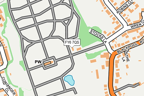
FY6 7QS is located in the Greenlands electoral ward, within the unitary authority of Blackpool and the English Parliamentary constituency of Blackpool North and Cleveleys. The Sub Integrated Care Board (ICB) Location is NHS Lancashire and South Cumbria ICB - 00R and the police force is Lancashire. This postcode has been in use since January 1980.


GetTheData
Source: OS OpenMap – Local (Ordnance Survey)
Source: OS VectorMap District (Ordnance Survey)
Licence: Open Government Licence (requires attribution)
| Easting | 333019 |
| Northing | 439437 |
| Latitude | 53.846833 |
| Longitude | -3.019573 |
GetTheData
Source: Open Postcode Geo
Licence: Open Government Licence
| Country | England |
| Postcode District | FY6 |
| ➜ FY6 open data dashboard ➜ See where FY6 is on a map ➜ Where is Carleton? | |
GetTheData
Source: Land Registry Price Paid Data
Licence: Open Government Licence
Elevation or altitude of FY6 7QS as distance above sea level:
| Metres | Feet | |
|---|---|---|
| Elevation | 20m | 66ft |
Elevation is measured from the approximate centre of the postcode, to the nearest point on an OS contour line from OS Terrain 50, which has contour spacing of ten vertical metres.
➜ How high above sea level am I? Find the elevation of your current position using your device's GPS.
GetTheData
Source: Open Postcode Elevation
Licence: Open Government Licence
| Ward | Greenlands |
| Constituency | Blackpool North And Cleveleys |
GetTheData
Source: ONS Postcode Database
Licence: Open Government Licence
| June 2022 | Violence and sexual offences | On or near Corriander Close | 326m |
| June 2022 | Burglary | On or near Fennel Close | 342m |
| May 2022 | Violence and sexual offences | On or near Stocks Lane | 145m |
| ➜ Get more crime data in our Crime section | |||
GetTheData
Source: data.police.uk
Licence: Open Government Licence
| Crematorium (Blackpool Road) | Carleton | 163m |
| Crematorium (Blackpool Road) | Carleton | 191m |
| Meadow Crescent (Blackpool Road) | Carleton | 350m |
| Meadow Crescent (Blackpool Road) | Carleton | 373m |
| Carlton Lodge Farm (Moorpark Avenue) | Moor Park | 444m |
| Layton (Lancs) Station | 1.5km |
| Poulton-le-Fylde Station | 1.9km |
| Blackpool North Station | 3.4km |
GetTheData
Source: NaPTAN
Licence: Open Government Licence
GetTheData
Source: ONS Postcode Database
Licence: Open Government Licence


➜ Get more ratings from the Food Standards Agency
GetTheData
Source: Food Standards Agency
Licence: FSA terms & conditions
| Last Collection | |||
|---|---|---|---|
| Location | Mon-Fri | Sat | Distance |
| Tarragon Drive | 16:00 | 11:00 | 438m |
| Little Carleton | 16:00 | 11:30 | 543m |
| Linden Place | 17:15 | 11:15 | 693m |
GetTheData
Source: Dracos
Licence: Creative Commons Attribution-ShareAlike
| Facility | Distance |
|---|---|
| Bispham Body Senze (Closed) Bristol Avenue, Blackpool Health and Fitness Gym, Studio | 652m |
| Moor Park / Extension Moor Park Avenue, Blackpool Grass Pitches | 962m |
| Cottam Hall Blackpool Old Road, Poulton-le-fylde Grass Pitches | 1km |
GetTheData
Source: Active Places
Licence: Open Government Licence
| School | Phase of Education | Distance |
|---|---|---|
| Moor Park Primary School Moor Park Avenue, Bispham, Blackpool, FY2 0LY | Primary | 768m |
| The Blackpool Sixth Form College Blackpool Old Road, Blackpool, FY3 7LR | 16 plus | 773m |
| Carleton St Hilda's Church of England Primary School Bispham Road, Carleton, Poulton-le-Fylde, FY6 7PE | Primary | 1.1km |
GetTheData
Source: Edubase
Licence: Open Government Licence
The below table lists the International Territorial Level (ITL) codes (formerly Nomenclature of Territorial Units for Statistics (NUTS) codes) and Local Administrative Units (LAU) codes for FY6 7QS:
| ITL 1 Code | Name |
|---|---|
| TLD | North West (England) |
| ITL 2 Code | Name |
| TLD4 | Lancashire |
| ITL 3 Code | Name |
| TLD42 | Blackpool |
| LAU 1 Code | Name |
| E06000009 | Blackpool |
GetTheData
Source: ONS Postcode Directory
Licence: Open Government Licence
The below table lists the Census Output Area (OA), Lower Layer Super Output Area (LSOA), and Middle Layer Super Output Area (MSOA) for FY6 7QS:
| Code | Name | |
|---|---|---|
| OA | E00063982 | |
| LSOA | E01012692 | Blackpool 004C |
| MSOA | E02002636 | Blackpool 004 |
GetTheData
Source: ONS Postcode Directory
Licence: Open Government Licence
| FY6 7QR | Stocks Lane | 150m |
| FY6 7PZ | Robins Lane | 186m |
| FY6 7QP | Robins Lane | 225m |
| FY6 7LN | The Lane | 237m |
| FY6 7QN | Robins Lane | 256m |
| FY6 7QW | Robins Close | 283m |
| FY6 7QL | Wren Close | 285m |
| FY2 0WJ | Tarragon Drive | 309m |
| FY2 0WA | Fennel Close | 319m |
| FY2 0WL | Tarragon Drive | 320m |
GetTheData
Source: Open Postcode Geo; Land Registry Price Paid Data
Licence: Open Government Licence