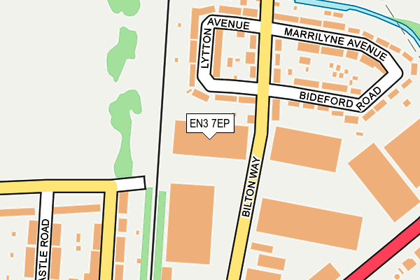
EN3 7EP is located in the Brimsdown electoral ward, within the London borough of Enfield and the English Parliamentary constituency of Enfield North. The Sub Integrated Care Board (ICB) Location is NHS North Central London ICB - 93C and the police force is Metropolitan Police. This postcode has been in use since December 1995.


GetTheData
Source: OS OpenMap – Local (Ordnance Survey)
Source: OS VectorMap District (Ordnance Survey)
Licence: Open Government Licence (requires attribution)
| Easting | 536463 |
| Northing | 198192 |
| Latitude | 51.665942 |
| Longitude | -0.028228 |
GetTheData
Source: Open Postcode Geo
Licence: Open Government Licence
| Country | England |
| Postcode District | EN3 |
| ➜ EN3 open data dashboard ➜ See where EN3 is on a map ➜ Where is London? | |
GetTheData
Source: Land Registry Price Paid Data
Licence: Open Government Licence
Elevation or altitude of EN3 7EP as distance above sea level:
| Metres | Feet | |
|---|---|---|
| Elevation | 20m | 66ft |
Elevation is measured from the approximate centre of the postcode, to the nearest point on an OS contour line from OS Terrain 50, which has contour spacing of ten vertical metres.
➜ How high above sea level am I? Find the elevation of your current position using your device's GPS.
GetTheData
Source: Open Postcode Elevation
Licence: Open Government Licence
| Ward | Brimsdown |
| Constituency | Enfield North |
GetTheData
Source: ONS Postcode Database
Licence: Open Government Licence
| June 2022 | Other theft | On or near Lytton Avenue | 126m |
| June 2022 | Public order | On or near Bilton Way | 140m |
| June 2022 | Anti-social behaviour | On or near Bilton Way | 156m |
| ➜ Get more crime data in our Crime section | |||
GetTheData
Source: data.police.uk
Licence: Open Government Licence
| Castle Road (En3) (Bell Lane) | Enfield Lock | 202m |
| Bilton Way Mollison Avenue | Enfield Lock | 255m |
| Castle Road (En3) (Bell Lane) | Enfield Lock | 283m |
| Bilton Way Mollison Avenue | Enfield Lock | 297m |
| Leys Road East (Brimsdown Avenue) | Brimsdown | 320m |
| Enfield Lock Station | 0.6km |
| Brimsdown Station | 1.2km |
| Turkey Street Station | 1.5km |
GetTheData
Source: NaPTAN
Licence: Open Government Licence
GetTheData
Source: ONS Postcode Database
Licence: Open Government Licence

➜ Get more ratings from the Food Standards Agency
GetTheData
Source: Food Standards Agency
Licence: FSA terms & conditions
| Last Collection | |||
|---|---|---|---|
| Location | Mon-Fri | Sat | Distance |
| Catisfield Road | 17:30 | 12:00 | 496m |
| Enfield Lock | 17:30 | 12:00 | 574m |
| Somerset Road | 17:30 | 12:00 | 709m |
GetTheData
Source: Dracos
Licence: Creative Commons Attribution-ShareAlike
| Facility | Distance |
|---|---|
| Albany Park Hertford Road, Enfield Grass Pitches, Outdoor Tennis Courts | 427m |
| Soham Road Recreation Ground Salisbury Road, Enfield Grass Pitches | 476m |
| Ark John Keats Academy Bell Lane, Enfield Artificial Grass Pitch, Health and Fitness Gym, Sports Hall, Outdoor Tennis Courts, Studio | 613m |
GetTheData
Source: Active Places
Licence: Open Government Licence
| School | Phase of Education | Distance |
|---|---|---|
| Prince of Wales Primary School Salisbury Road, Enfield, EN3 6HG | Primary | 466m |
| Chesterfield Primary School Chesterfield Road, Enfield, EN3 6BG | Primary | 474m |
| Fern House School Keswick Drive, Enfield, EN3 6NY | Not applicable | 521m |
GetTheData
Source: Edubase
Licence: Open Government Licence
The below table lists the International Territorial Level (ITL) codes (formerly Nomenclature of Territorial Units for Statistics (NUTS) codes) and Local Administrative Units (LAU) codes for EN3 7EP:
| ITL 1 Code | Name |
|---|---|
| TLI | London |
| ITL 2 Code | Name |
| TLI5 | Outer London - East and North East |
| ITL 3 Code | Name |
| TLI54 | Enfield |
| LAU 1 Code | Name |
| E09000010 | Enfield |
GetTheData
Source: ONS Postcode Directory
Licence: Open Government Licence
The below table lists the Census Output Area (OA), Lower Layer Super Output Area (LSOA), and Middle Layer Super Output Area (MSOA) for EN3 7EP:
| Code | Name | |
|---|---|---|
| OA | E00007155 | |
| LSOA | E01001433 | Enfield 007A |
| MSOA | E02000283 | Enfield 007 |
GetTheData
Source: ONS Postcode Directory
Licence: Open Government Licence
| EN3 6EJ | Bilton Way | 102m |
| EN3 6EL | Lytton Avenue | 123m |
| EN3 6EN | Lytton Avenue | 132m |
| EN3 6EW | Bilton Way | 148m |
| EN3 6EH | Bideford Road | 204m |
| EN3 5EU | Park Terrace | 209m |
| EN3 6EQ | Marrilyne Avenue | 225m |
| EN3 5HX | Brimsdown Avenue | 242m |
| EN3 6LT | Bradley Road | 245m |
| EN3 6EG | Marrilyne Avenue | 250m |
GetTheData
Source: Open Postcode Geo; Land Registry Price Paid Data
Licence: Open Government Licence