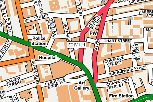
EC1V 1JH is located in the Hoxton West electoral ward, within the London borough of Hackney and the English Parliamentary constituency of Hackney South and Shoreditch. The Sub Integrated Care Board (ICB) Location is NHS North East London ICB - A3A8R and the police force is Metropolitan Police. This postcode has been in use since April 2016.


GetTheData
Source: OS OpenMap – Local (Ordnance Survey)
Source: OS VectorMap District (Ordnance Survey)
Licence: Open Government Licence (requires attribution)
| Easting | 532663 |
| Northing | 182735 |
| Latitude | 51.527951 |
| Longitude | -0.088980 |
GetTheData
Source: Open Postcode Geo
Licence: Open Government Licence
| Country | England |
| Postcode District | EC1V |
| ➜ EC1V open data dashboard ➜ See where EC1V is on a map ➜ Where is London? | |
GetTheData
Source: Land Registry Price Paid Data
Licence: Open Government Licence
Elevation or altitude of EC1V 1JH as distance above sea level:
| Metres | Feet | |
|---|---|---|
| Elevation | 20m | 66ft |
Elevation is measured from the approximate centre of the postcode, to the nearest point on an OS contour line from OS Terrain 50, which has contour spacing of ten vertical metres.
➜ How high above sea level am I? Find the elevation of your current position using your device's GPS.
GetTheData
Source: Open Postcode Elevation
Licence: Open Government Licence
| Ward | Hoxton West |
| Constituency | Hackney South And Shoreditch |
GetTheData
Source: ONS Postcode Database
Licence: Open Government Licence
| January 2024 | Other theft | On or near Ebenezer Street | 69m |
| January 2024 | Theft from the person | On or near Ebenezer Street | 69m |
| January 2024 | Bicycle theft | On or near Peerless Street | 124m |
| ➜ Get more crime data in our Crime section | |||
GetTheData
Source: data.police.uk
Licence: Open Government Licence
| Moorfields Eye Hospital (Provost Street) | Old Street | 32m |
| Old Street (City Road) | Old Street | 81m |
| Old Street Stn Moorfields | Shoreditch | 97m |
| Old Street | Old Street | 114m |
| Moorfields Eye Hospital (City Road) | Old Street | 122m |
| Old Street Underground Station | Old Street | 247m |
| Barbican Underground Station | Barbican | 1,059m |
| Moorgate Underground Station | Moorgate | 1,089m |
| Liverpool Street Underground Station | Liverpool Street | 1,244m |
| Angel Underground Station | Angel | 1,284m |
| Old Street Station | 0.2km |
| Hoxton Station | 1km |
| Moorgate Station | 1.1km |
GetTheData
Source: NaPTAN
Licence: Open Government Licence
GetTheData
Source: ONS Postcode Database
Licence: Open Government Licence


➜ Get more ratings from the Food Standards Agency
GetTheData
Source: Food Standards Agency
Licence: FSA terms & conditions
| Last Collection | |||
|---|---|---|---|
| Location | Mon-Fri | Sat | Distance |
| City Road (Opp Bath St) | 18:30 | 12:00 | 183m |
| East Road/Bevenden Street | 18:30 | 12:00 | 229m |
| Old Street Branch Office | 18:30 | 12:00 | 237m |
GetTheData
Source: Dracos
Licence: Creative Commons Attribution-ShareAlike
| Facility | Distance |
|---|---|
| Blue Hut Youth Centre Provost Street, Provost Street, London Artificial Grass Pitch | 213m |
| Gambier Hall Mora Street, London Studio | 255m |
| Gymbox (Old Street) Old Street, London Health and Fitness Gym, Studio | 263m |
GetTheData
Source: Active Places
Licence: Open Government Licence
| School | Phase of Education | Distance |
|---|---|---|
| New Regent's College Nile Street, London, N1 7RD | Not applicable | 190m |
| St Luke's CofE Primary School Radnor Street, London, EC1V 3SJ | Primary | 256m |
| Central Foundation Boys' School Cowper Street, City Road, London, EC2A 4SH | Secondary | 370m |
GetTheData
Source: Edubase
Licence: Open Government Licence
The below table lists the International Territorial Level (ITL) codes (formerly Nomenclature of Territorial Units for Statistics (NUTS) codes) and Local Administrative Units (LAU) codes for EC1V 1JH:
| ITL 1 Code | Name |
|---|---|
| TLI | London |
| ITL 2 Code | Name |
| TLI4 | Inner London - East |
| ITL 3 Code | Name |
| TLI41 | Hackney and Newham |
| LAU 1 Code | Name |
| E09000012 | Hackney |
GetTheData
Source: ONS Postcode Directory
Licence: Open Government Licence
The below table lists the Census Output Area (OA), Lower Layer Super Output Area (LSOA), and Middle Layer Super Output Area (MSOA) for EC1V 1JH:
| Code | Name | |
|---|---|---|
| OA | E00176282 | |
| LSOA | E01033711 | Hackney 027I |
| MSOA | E02000371 | Hackney 027 |
GetTheData
Source: ONS Postcode Directory
Licence: Open Government Licence
| EC1V 1AQ | City Road | 48m |
| EC1V 1AR | City Road | 48m |
| EC1V 1AT | City Road | 48m |
| N1 7GN | Britannia Walk | 48m |
| N1 7RH | Britannia Walk | 48m |
| N1 7RP | Ebenezer Street | 52m |
| N1 7NS | Britannia Walk | 78m |
| N1 7LU | Britannia Walk | 89m |
| N1 7NP | Ebenezer Street | 89m |
| N1 7NH | Provost Street | 92m |
GetTheData
Source: Open Postcode Geo; Land Registry Price Paid Data
Licence: Open Government Licence