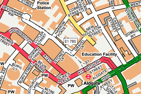
E1 7BS is located in the Portsoken electoral ward, within the London borough of City of London and the English Parliamentary constituency of Cities of London and Westminster. The Sub Integrated Care Board (ICB) Location is NHS North East London ICB - A3A8R and the police force is City of London. This postcode has been in use since January 1980.


GetTheData
Source: OS OpenMap – Local (Ordnance Survey)
Source: OS VectorMap District (Ordnance Survey)
Licence: Open Government Licence (requires attribution)
| Easting | 533544 |
| Northing | 181365 |
| Latitude | 51.515432 |
| Longitude | -0.076806 |
GetTheData
Source: Open Postcode Geo
Licence: Open Government Licence
| Country | England |
| Postcode District | E1 |
| ➜ E1 open data dashboard ➜ See where E1 is on a map ➜ Where is City of London? | |
GetTheData
Source: Land Registry Price Paid Data
Licence: Open Government Licence
Elevation or altitude of E1 7BS as distance above sea level:
| Metres | Feet | |
|---|---|---|
| Elevation | 10m | 33ft |
Elevation is measured from the approximate centre of the postcode, to the nearest point on an OS contour line from OS Terrain 50, which has contour spacing of ten vertical metres.
➜ How high above sea level am I? Find the elevation of your current position using your device's GPS.
GetTheData
Source: Open Postcode Elevation
Licence: Open Government Licence
| Ward | Portsoken |
| Constituency | Cities Of London And Westminster |
GetTheData
Source: ONS Postcode Database
Licence: Open Government Licence
| January 2024 | Drugs | On or near Little Somerset Street | 263m |
| January 2024 | Other crime | On or near Little Somerset Street | 263m |
| January 2024 | Other theft | On or near Little Somerset Street | 263m |
| ➜ Get more crime data in our Crime section | |||
GetTheData
Source: data.police.uk
Licence: Open Government Licence
| St Botolph Street | City Of London | 127m |
| St Botolph Street | City Of London | 129m |
| Duke's Place | City Of London | 162m |
| Aldgate | Aldgate | 192m |
| Aldgate | Aldgate | 196m |
| Aldgate Underground Station | Aldgate | 153m |
| Aldgate East Underground Station | Aldgate East | 310m |
| Liverpool Street Underground Station | Liverpool Street | 492m |
| Tower Gateway Dlr Station (Minories) | Tower Gateway | 553m |
| Tower Hill Underground Station | Tower Hill | 608m |
| London Liverpool Street Station | 0.4km |
| London Fenchurch Street Station | 0.4km |
| Shoreditch High Street Station | 0.9km |
GetTheData
Source: NaPTAN
Licence: Open Government Licence
GetTheData
Source: ONS Postcode Database
Licence: Open Government Licence


➜ Get more ratings from the Food Standards Agency
GetTheData
Source: Food Standards Agency
Licence: FSA terms & conditions
| Last Collection | |||
|---|---|---|---|
| Location | Mon-Fri | Sat | Distance |
| Wapping High Street | 18:30 | 21m | |
| Harrow Place | 18:30 | 11:30 | 109m |
| Harrow Place | 18:30 | 11:30 | 119m |
GetTheData
Source: Dracos
Licence: Creative Commons Attribution-ShareAlike
| Facility | Distance |
|---|---|
| Puregym (London Aldgate) Houndsditch, London Health and Fitness Gym, Studio | 101m |
| The Aldgate School St. James's Passage, London Sports Hall | 202m |
| No1 Fitness City Studio St. Mary Axe, London Health and Fitness Gym, Studio | 222m |
GetTheData
Source: Active Places
Licence: Open Government Licence
| School | Phase of Education | Distance |
|---|---|---|
| The Aldgate School St James's Passage, Duke's Place, London, EC3A 5DE | Primary | 170m |
| David Game College 31 Jewry Street, London, EC3N 2ET | Not applicable | 289m |
| Royal Mencap Society 20-22 Commercial Street, Spitalfields, London, E1 6LP | Not applicable | 328m |
GetTheData
Source: Edubase
Licence: Open Government Licence
The below table lists the International Territorial Level (ITL) codes (formerly Nomenclature of Territorial Units for Statistics (NUTS) codes) and Local Administrative Units (LAU) codes for E1 7BS:
| ITL 1 Code | Name |
|---|---|
| TLI | London |
| ITL 2 Code | Name |
| TLI3 | Inner London - West |
| ITL 3 Code | Name |
| TLI31 | Camden and City of London |
| LAU 1 Code | Name |
| E09000001 | City of London |
GetTheData
Source: ONS Postcode Directory
Licence: Open Government Licence
The below table lists the Census Output Area (OA), Lower Layer Super Output Area (LSOA), and Middle Layer Super Output Area (MSOA) for E1 7BS:
| Code | Name | |
|---|---|---|
| OA | E00000030 | |
| LSOA | E01000005 | City of London 001E |
| MSOA | E02000001 | City of London 001 |
GetTheData
Source: ONS Postcode Directory
Licence: Open Government Licence
| E1 7EE | Petticoat Square | 46m |
| E1 7EF | Petticoat Tower | 46m |
| E1 7EA | Petticoat Square | 72m |
| E1 7EB | Petticoat Square | 72m |
| E1 7ED | Petticoat Square | 72m |
| E1 7EX | Middlesex Street | 101m |
| EC3A 7DT | St Botolph Street | 107m |
| E1 7EY | Middlesex Street | 107m |
| E1 7PN | New Goulston Street | 121m |
| E1 7TB | Wentworth Street | 142m |
GetTheData
Source: Open Postcode Geo; Land Registry Price Paid Data
Licence: Open Government Licence