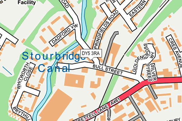
DY5 3RA is located in the Brierley Hill electoral ward, within the metropolitan district of Dudley and the English Parliamentary constituency of Dudley South. The Sub Integrated Care Board (ICB) Location is NHS Black Country ICB - D2P2L and the police force is West Midlands. This postcode has been in use since January 1980.


GetTheData
Source: OS OpenMap – Local (Ordnance Survey)
Source: OS VectorMap District (Ordnance Survey)
Licence: Open Government Licence (requires attribution)
| Easting | 390808 |
| Northing | 286473 |
| Latitude | 52.476121 |
| Longitude | -2.136754 |
GetTheData
Source: Open Postcode Geo
Licence: Open Government Licence
| Country | England |
| Postcode District | DY5 |
| ➜ DY5 open data dashboard ➜ See where DY5 is on a map ➜ Where is Brierley Hill? | |
GetTheData
Source: Land Registry Price Paid Data
Licence: Open Government Licence
Elevation or altitude of DY5 3RA as distance above sea level:
| Metres | Feet | |
|---|---|---|
| Elevation | 120m | 394ft |
Elevation is measured from the approximate centre of the postcode, to the nearest point on an OS contour line from OS Terrain 50, which has contour spacing of ten vertical metres.
➜ How high above sea level am I? Find the elevation of your current position using your device's GPS.
GetTheData
Source: Open Postcode Elevation
Licence: Open Government Licence
| Ward | Brierley Hill |
| Constituency | Dudley South |
GetTheData
Source: ONS Postcode Database
Licence: Open Government Licence
| June 2023 | Vehicle crime | On or near Bull Street | 115m |
| June 2022 | Vehicle crime | On or near Shopping Area | 64m |
| June 2022 | Anti-social behaviour | On or near Bull Street | 115m |
| ➜ Get more crime data in our Crime section | |||
GetTheData
Source: data.police.uk
Licence: Open Government Licence
| Crescent Avenue (Brettell Lane) | Silver End | 205m |
| Meeting Lane (Brettell Lane) | Silver End | 207m |
| Crescent Avenue (Brettell Lane) | Silver End | 255m |
| Meeting Lane (Brettell Lane) | Silver End | 256m |
| Hawbush Rd (Brettell Lane) | Silver End | 412m |
| Lye (West Midlands) Station | 2.3km |
| Stourbridge Town Station | 2.3km |
| Stourbridge Junction Station | 3.2km |
GetTheData
Source: NaPTAN
Licence: Open Government Licence
Estimated total energy consumption in DY5 3RA by fuel type, 2015.
| Consumption (kWh) | 111,896 |
|---|---|
| Meter count | 11 |
| Mean (kWh/meter) | 10,172 |
| Median (kWh/meter) | 11,170 |
GetTheData
Source: Postcode level gas estimates: 2015 (experimental)
Source: Postcode level electricity estimates: 2015 (experimental)
Licence: Open Government Licence
GetTheData
Source: ONS Postcode Database
Licence: Open Government Licence


➜ Get more ratings from the Food Standards Agency
GetTheData
Source: Food Standards Agency
Licence: FSA terms & conditions
| Last Collection | |||
|---|---|---|---|
| Location | Mon-Fri | Sat | Distance |
| Silver End Post Office | 17:30 | 12:00 | 243m |
| Church Street | 17:30 | 12:00 | 672m |
| Little Potter Street | 17:30 | 11:30 | 900m |
GetTheData
Source: Dracos
Licence: Creative Commons Attribution-ShareAlike
| Facility | Distance |
|---|---|
| Hawbush Primary School Hawbush Road, Brierley Hill Grass Pitches | 323m |
| Dudley Sport Junior And Girls Football Club Hillcrest Avenue, Brierley Hill Grass Pitches | 483m |
| Withymoor Playing Fields Turners Lane, Brierley Hill Grass Pitches | 541m |
GetTheData
Source: Active Places
Licence: Open Government Licence
| School | Phase of Education | Distance |
|---|---|---|
| Hawbush Primary School Hawbush Road, Brierley Hill, DY5 3NH | Primary | 356m |
| Hawbush Primary School Hawbush Road, Brierley Hill, DY5 3NH | Primary | 393m |
| Brockmoor Primary School Belle Isle, Brockmoor, Brierley Hill, DY5 3UZ | Primary | 967m |
GetTheData
Source: Edubase
Licence: Open Government Licence
The below table lists the International Territorial Level (ITL) codes (formerly Nomenclature of Territorial Units for Statistics (NUTS) codes) and Local Administrative Units (LAU) codes for DY5 3RA:
| ITL 1 Code | Name |
|---|---|
| TLG | West Midlands (England) |
| ITL 2 Code | Name |
| TLG3 | West Midlands |
| ITL 3 Code | Name |
| TLG36 | Dudley |
| LAU 1 Code | Name |
| E08000027 | Dudley |
GetTheData
Source: ONS Postcode Directory
Licence: Open Government Licence
The below table lists the Census Output Area (OA), Lower Layer Super Output Area (LSOA), and Middle Layer Super Output Area (MSOA) for DY5 3RA:
| Code | Name | |
|---|---|---|
| OA | E00049297 | |
| LSOA | E01009740 | Dudley 023B |
| MSOA | E02002022 | Dudley 023 |
GetTheData
Source: ONS Postcode Directory
Licence: Open Government Licence
| DY5 3RD | Springfield Road | 105m |
| DY5 3TX | Dadford View | 116m |
| DY5 3RB | Springfield Road | 141m |
| DY5 3QB | Bull Street | 147m |
| DY5 3SX | Dadford View | 167m |
| DY5 3JN | Brettell Lane | 187m |
| DY5 3QU | Goldencross Way | 188m |
| DY5 3LW | Whitworth Close | 203m |
| DY5 3RG | Eastern Avenue | 224m |
| DY5 3QR | Brettell Lane | 232m |
GetTheData
Source: Open Postcode Geo; Land Registry Price Paid Data
Licence: Open Government Licence