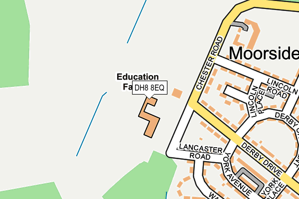
DH8 8EQ is located in the Consett South electoral ward, within the unitary authority of County Durham and the English Parliamentary constituency of North West Durham. The Sub Integrated Care Board (ICB) Location is NHS North East and North Cumbria ICB - 84H and the police force is Durham. This postcode has been in use since January 1980.


GetTheData
Source: OS OpenMap – Local (Ordnance Survey)
Source: OS VectorMap District (Ordnance Survey)
Licence: Open Government Licence (requires attribution)
| Easting | 408197 |
| Northing | 549361 |
| Latitude | 54.839011 |
| Longitude | -1.873908 |
GetTheData
Source: Open Postcode Geo
Licence: Open Government Licence
| Country | England |
| Postcode District | DH8 |
| ➜ DH8 open data dashboard ➜ See where DH8 is on a map ➜ Where is Consett? | |
GetTheData
Source: Land Registry Price Paid Data
Licence: Open Government Licence
Elevation or altitude of DH8 8EQ as distance above sea level:
| Metres | Feet | |
|---|---|---|
| Elevation | 190m | 623ft |
Elevation is measured from the approximate centre of the postcode, to the nearest point on an OS contour line from OS Terrain 50, which has contour spacing of ten vertical metres.
➜ How high above sea level am I? Find the elevation of your current position using your device's GPS.
GetTheData
Source: Open Postcode Elevation
Licence: Open Government Licence
| Ward | Consett South |
| Constituency | North West Durham |
GetTheData
Source: ONS Postcode Database
Licence: Open Government Licence
| June 2022 | Anti-social behaviour | On or near Chester Road | 100m |
| June 2022 | Anti-social behaviour | On or near Chester Road | 100m |
| June 2022 | Anti-social behaviour | On or near Chester Road | 100m |
| ➜ Get more crime data in our Crime section | |||
GetTheData
Source: data.police.uk
Licence: Open Government Licence
| Chester Road | Moorside | 98m |
| Chester Road | Moorside | 118m |
| Derby Drive - Top (Derby Drive) | Moorside | 158m |
| Derby Drive - Top (Derby Drive) | Moorside | 221m |
| Rutland Road (Dunelm Road) | Moorside | 408m |
GetTheData
Source: NaPTAN
Licence: Open Government Licence
GetTheData
Source: ONS Postcode Database
Licence: Open Government Licence


➜ Get more ratings from the Food Standards Agency
GetTheData
Source: Food Standards Agency
Licence: FSA terms & conditions
| Last Collection | |||
|---|---|---|---|
| Location | Mon-Fri | Sat | Distance |
| The Grove | 16:15 | 12:00 | 1,317m |
| Barley Mill Road, Bridgehill | 16:00 | 11:45 | 2,330m |
| Hownsgill Industrial Estate | 16:15 | 12:00 | 2,388m |
GetTheData
Source: Dracos
Licence: Creative Commons Attribution-ShareAlike
| Facility | Distance |
|---|---|
| Moorside Primary School Chester Road, Consett Grass Pitches | 43m |
| Castleside Primary School Moorland Crescent, Consett Grass Pitches | 692m |
| St Pius Xth Rc Primary School Thornfield Road, The Grove Grass Pitches | 1.2km |
GetTheData
Source: Active Places
Licence: Open Government Licence
| School | Phase of Education | Distance |
|---|---|---|
| Moorside Primary Academy Chester Road, Moorside, Consett, DH8 8EQ | Primary | 43m |
| Castleside Primary School Moorland Crescent, Castleside, Consett, DH8 9RG | Primary | 692m |
| St Pius Xth Catholic Primary School, Consett Thornfield Road, The Grove, Consett, DH8 8AX | Primary | 1.2km |
GetTheData
Source: Edubase
Licence: Open Government Licence
The below table lists the International Territorial Level (ITL) codes (formerly Nomenclature of Territorial Units for Statistics (NUTS) codes) and Local Administrative Units (LAU) codes for DH8 8EQ:
| ITL 1 Code | Name |
|---|---|
| TLC | North East (England) |
| ITL 2 Code | Name |
| TLC1 | Tees Valley and Durham |
| ITL 3 Code | Name |
| TLC14 | Durham |
| LAU 1 Code | Name |
| E06000047 | County Durham |
GetTheData
Source: ONS Postcode Directory
Licence: Open Government Licence
The below table lists the Census Output Area (OA), Lower Layer Super Output Area (LSOA), and Middle Layer Super Output Area (MSOA) for DH8 8EQ:
| Code | Name | |
|---|---|---|
| OA | E00104744 | |
| LSOA | E01020645 | County Durham 014E |
| MSOA | E02004305 | County Durham 014 |
GetTheData
Source: ONS Postcode Directory
Licence: Open Government Licence
| DH8 8DY | Chester Road | 127m |
| DH8 8DX | Derby Drive | 144m |
| DH8 8DR | Lancaster Road | 152m |
| DH8 8EA | Lincoln Place | 175m |
| DH8 8EB | Lincoln Road | 227m |
| DH8 8DP | Warwick Avenue | 264m |
| DH8 8DU | Derby Drive | 276m |
| DH8 8DZ | Derby Crescent | 289m |
| DH8 8ED | Rutland Road | 291m |
| DH8 8DS | York Avenue | 294m |
GetTheData
Source: Open Postcode Geo; Land Registry Price Paid Data
Licence: Open Government Licence