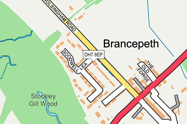
DH7 8EP is located in the Willington and Hunwick electoral ward, within the unitary authority of County Durham and the English Parliamentary constituency of City of Durham. The Sub Integrated Care Board (ICB) Location is NHS North East and North Cumbria ICB - 84H and the police force is Durham. This postcode has been in use since March 1988.


GetTheData
Source: OS OpenMap – Local (Ordnance Survey)
Source: OS VectorMap District (Ordnance Survey)
Licence: Open Government Licence (requires attribution)
| Easting | 422046 |
| Northing | 538098 |
| Latitude | 54.737376 |
| Longitude | -1.659125 |
GetTheData
Source: Open Postcode Geo
Licence: Open Government Licence
| Country | England |
| Postcode District | DH7 |
| ➜ DH7 open data dashboard ➜ See where DH7 is on a map ➜ Where is Brancepeth? | |
GetTheData
Source: Land Registry Price Paid Data
Licence: Open Government Licence
Elevation or altitude of DH7 8EP as distance above sea level:
| Metres | Feet | |
|---|---|---|
| Elevation | 110m | 361ft |
Elevation is measured from the approximate centre of the postcode, to the nearest point on an OS contour line from OS Terrain 50, which has contour spacing of ten vertical metres.
➜ How high above sea level am I? Find the elevation of your current position using your device's GPS.
GetTheData
Source: Open Postcode Elevation
Licence: Open Government Licence
| Ward | Willington And Hunwick |
| Constituency | City Of Durham |
GetTheData
Source: ONS Postcode Database
Licence: Open Government Licence
| December 2023 | Anti-social behaviour | On or near Parking Area | 155m |
| May 2023 | Criminal damage and arson | On or near Parking Area | 155m |
| June 2022 | Violence and sexual offences | On or near Goodwell Lea | 43m |
| ➜ Get more crime data in our Crime section | |||
GetTheData
Source: data.police.uk
Licence: Open Government Licence
| Village (A690) | Brancepeth | 198m |
| Village (A690) | Brancepeth | 199m |
| Stockley Lane End (Stockley Lane) | Brancepeth | 593m |
| Stockley Lane End (Stockley Lane) | Brancepeth | 603m |
| Little White Farm (A690) | Brancepeth | 639m |
| Durham Station | 6.8km |
GetTheData
Source: NaPTAN
Licence: Open Government Licence
| Percentage of properties with Next Generation Access | 100.0% |
| Percentage of properties with Superfast Broadband | 100.0% |
| Percentage of properties with Ultrafast Broadband | 0.0% |
| Percentage of properties with Full Fibre Broadband | 0.0% |
Superfast Broadband is between 30Mbps and 300Mbps
Ultrafast Broadband is > 300Mbps
| Percentage of properties unable to receive 2Mbps | 0.0% |
| Percentage of properties unable to receive 5Mbps | 0.0% |
| Percentage of properties unable to receive 10Mbps | 0.0% |
| Percentage of properties unable to receive 30Mbps | 0.0% |
GetTheData
Source: Ofcom
Licence: Ofcom Terms of Use (requires attribution)
GetTheData
Source: ONS Postcode Database
Licence: Open Government Licence


➜ Get more ratings from the Food Standards Agency
GetTheData
Source: Food Standards Agency
Licence: FSA terms & conditions
| Last Collection | |||
|---|---|---|---|
| Location | Mon-Fri | Sat | Distance |
| Brancepeth | 16:00 | 11:30 | 111m |
| Dere Park | 16:00 | 08:30 | 1,281m |
| Clover Laird | 16:00 | 09:45 | 1,736m |
GetTheData
Source: Dracos
Licence: Creative Commons Attribution-ShareAlike
| Facility | Distance |
|---|---|
| Brancepeth Castle Golf Club Ltd Brancepeth, Durham Golf | 701m |
| Vicarage (Closed) Vicarage Flats, Brandon, Durham Grass Pitches | 2.4km |
| Dorlonco Playing Field Dorlonco Villas, Meadowfield Grass Pitches | 2.6km |
GetTheData
Source: Active Places
Licence: Open Government Licence
| School | Phase of Education | Distance |
|---|---|---|
| Brandon Primary Academy Carr Avenue, Brandon, Durham, DH7 8NL | Primary | 2.4km |
| The Grange Learning Centre Low Willington, DL15 0TY | Not applicable | 2.9km |
| Browney Primary Academy Harle Street, Browney, DH7 8HX | Primary | 2.9km |
GetTheData
Source: Edubase
Licence: Open Government Licence
The below table lists the International Territorial Level (ITL) codes (formerly Nomenclature of Territorial Units for Statistics (NUTS) codes) and Local Administrative Units (LAU) codes for DH7 8EP:
| ITL 1 Code | Name |
|---|---|
| TLC | North East (England) |
| ITL 2 Code | Name |
| TLC1 | Tees Valley and Durham |
| ITL 3 Code | Name |
| TLC14 | Durham |
| LAU 1 Code | Name |
| E06000047 | County Durham |
GetTheData
Source: ONS Postcode Directory
Licence: Open Government Licence
The below table lists the Census Output Area (OA), Lower Layer Super Output Area (LSOA), and Middle Layer Super Output Area (MSOA) for DH7 8EP:
| Code | Name | |
|---|---|---|
| OA | E00104958 | |
| LSOA | E01020685 | County Durham 038A |
| MSOA | E02004317 | County Durham 038 |
GetTheData
Source: ONS Postcode Directory
Licence: Open Government Licence
| DH7 8EN | Goodwell Lea | 60m |
| DH7 8DH | Foxes Row | 140m |
| DH7 8EW | The Forge | 156m |
| DH7 8DL | Railway Cottages | 187m |
| DH7 8DG | The Village | 213m |
| DH7 8DQ | Durham Road | 221m |
| DH7 8DD | Rectory Cottages | 296m |
| DH7 8EL | 307m | |
| DH7 8DT | 328m | |
| DH7 8DE | 329m |
GetTheData
Source: Open Postcode Geo; Land Registry Price Paid Data
Licence: Open Government Licence