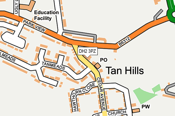
DH2 3PZ lies on Eureka Terrace in Tan Hills, Chester Le Street. DH2 3PZ is located in the Sacriston electoral ward, within the unitary authority of County Durham and the English Parliamentary constituency of North Durham. The Sub Integrated Care Board (ICB) Location is NHS North East and North Cumbria ICB - 84H and the police force is Durham. This postcode has been in use since June 1997.


GetTheData
Source: OS OpenMap – Local (Ordnance Survey)
Source: OS VectorMap District (Ordnance Survey)
Licence: Open Government Licence (requires attribution)
| Easting | 425923 |
| Northing | 547607 |
| Latitude | 54.822651 |
| Longitude | -1.598080 |
GetTheData
Source: Open Postcode Geo
Licence: Open Government Licence
| Street | Eureka Terrace |
| Locality | Tan Hills |
| Town/City | Chester Le Street |
| Country | England |
| Postcode District | DH2 |
| ➜ DH2 open data dashboard ➜ See where DH2 is on a map ➜ Where is Tan Hills? | |
GetTheData
Source: Land Registry Price Paid Data
Licence: Open Government Licence
Elevation or altitude of DH2 3PZ as distance above sea level:
| Metres | Feet | |
|---|---|---|
| Elevation | 100m | 328ft |
Elevation is measured from the approximate centre of the postcode, to the nearest point on an OS contour line from OS Terrain 50, which has contour spacing of ten vertical metres.
➜ How high above sea level am I? Find the elevation of your current position using your device's GPS.
GetTheData
Source: Open Postcode Elevation
Licence: Open Government Licence
| Ward | Sacriston |
| Constituency | North Durham |
GetTheData
Source: ONS Postcode Database
Licence: Open Government Licence
| May 2023 | Anti-social behaviour | On or near Hawthorn Close | 108m |
| May 2023 | Violence and sexual offences | On or near Hawthorn Close | 108m |
| April 2023 | Violence and sexual offences | On or near Hawthorn Close | 108m |
| ➜ Get more crime data in our Crime section | |||
GetTheData
Source: data.police.uk
Licence: Open Government Licence
| Club (B6312) | Nettlesworth | 61m |
| Club (B6312) | Nettlesworth | 102m |
| Bank (B6312) | Nettlesworth | 190m |
| Bank (B6312) | Nettlesworth | 191m |
| Cedar Avenue | Kimblesworth | 221m |
| Chester-le-Street Station | 3.8km |
| Durham Station | 4.9km |
GetTheData
Source: NaPTAN
Licence: Open Government Licence
| Percentage of properties with Next Generation Access | 100.0% |
| Percentage of properties with Superfast Broadband | 100.0% |
| Percentage of properties with Ultrafast Broadband | 0.0% |
| Percentage of properties with Full Fibre Broadband | 0.0% |
Superfast Broadband is between 30Mbps and 300Mbps
Ultrafast Broadband is > 300Mbps
| Percentage of properties unable to receive 2Mbps | 0.0% |
| Percentage of properties unable to receive 5Mbps | 0.0% |
| Percentage of properties unable to receive 10Mbps | 0.0% |
| Percentage of properties unable to receive 30Mbps | 0.0% |
GetTheData
Source: Ofcom
Licence: Ofcom Terms of Use (requires attribution)
GetTheData
Source: ONS Postcode Database
Licence: Open Government Licence


➜ Get more ratings from the Food Standards Agency
GetTheData
Source: Food Standards Agency
Licence: FSA terms & conditions
| Last Collection | |||
|---|---|---|---|
| Location | Mon-Fri | Sat | Distance |
| Tanhills Post Office | 17:00 | 11:45 | 25m |
| Viola Crescent, Sacriston | 16:50 | 09:15 | 1,403m |
| Plawsworth Road, Sacriston | 16:50 | 07:30 | 1,473m |
GetTheData
Source: Dracos
Licence: Creative Commons Attribution-ShareAlike
| Facility | Distance |
|---|---|
| Nettlesworth Playing Field Ugly Lane, Nettlesworth Grass Pitches | 449m |
| Kimblesworth Cricket Club East Parade, Kimblesworth, Chester Le Street Grass Pitches | 474m |
| Chester Le Street Town Fc Union Lane, Chester Moor, Chester Le Street Grass Pitches, Artificial Grass Pitch | 1.7km |
GetTheData
Source: Active Places
Licence: Open Government Licence
| School | Phase of Education | Distance |
|---|---|---|
| Nettlesworth Primary School Front Street, Nettlesworth, Chester le Street, DH2 3PF | Primary | 261m |
| St Bede's Catholic Primary School, Sacriston Front Street, Sacriston, Durham, DH7 6AB | Primary | 2km |
| Sacriston Academy Witton Road, Sacriston, Durham, DH7 6LQ | Primary | 2km |
GetTheData
Source: Edubase
Licence: Open Government Licence
The below table lists the International Territorial Level (ITL) codes (formerly Nomenclature of Territorial Units for Statistics (NUTS) codes) and Local Administrative Units (LAU) codes for DH2 3PZ:
| ITL 1 Code | Name |
|---|---|
| TLC | North East (England) |
| ITL 2 Code | Name |
| TLC1 | Tees Valley and Durham |
| ITL 3 Code | Name |
| TLC14 | Durham |
| LAU 1 Code | Name |
| E06000047 | County Durham |
GetTheData
Source: ONS Postcode Directory
Licence: Open Government Licence
The below table lists the Census Output Area (OA), Lower Layer Super Output Area (LSOA), and Middle Layer Super Output Area (MSOA) for DH2 3PZ:
| Code | Name | |
|---|---|---|
| OA | E00104548 | |
| LSOA | E01020607 | County Durham 019B |
| MSOA | E02004296 | County Durham 019 |
GetTheData
Source: ONS Postcode Directory
Licence: Open Government Licence
| DH2 3UE | Eureka Mews | 23m |
| DH2 3PA | 41m | |
| DH2 3RA | Acorn Way | 78m |
| DH2 3PY | Tanmeads | 110m |
| DH2 3NU | 121m | |
| DH2 3PX | Tanmeads | 122m |
| DH2 3QG | Hawthorn Close | 140m |
| DH2 3QX | Glenmeads | 158m |
| DH2 3QA | Oak Crescent | 193m |
| DH2 3QE | Church View | 194m |
GetTheData
Source: Open Postcode Geo; Land Registry Price Paid Data
Licence: Open Government Licence