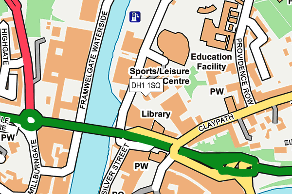
DH1 1SQ is located in the Elvet and Gilesgate electoral ward, within the unitary authority of County Durham and the English Parliamentary constituency of City of Durham. The Sub Integrated Care Board (ICB) Location is NHS North East and North Cumbria ICB - 84H and the police force is Durham. This postcode has been in use since December 1998.


GetTheData
Source: OS OpenMap – Local (Ordnance Survey)
Source: OS VectorMap District (Ordnance Survey)
Licence: Open Government Licence (requires attribution)
| Easting | 427391 |
| Northing | 542706 |
| Latitude | 54.778523 |
| Longitude | -1.575682 |
GetTheData
Source: Open Postcode Geo
Licence: Open Government Licence
| Country | England |
| Postcode District | DH1 |
| ➜ DH1 open data dashboard ➜ See where DH1 is on a map ➜ Where is Durham? | |
GetTheData
Source: Land Registry Price Paid Data
Licence: Open Government Licence
Elevation or altitude of DH1 1SQ as distance above sea level:
| Metres | Feet | |
|---|---|---|
| Elevation | 40m | 131ft |
Elevation is measured from the approximate centre of the postcode, to the nearest point on an OS contour line from OS Terrain 50, which has contour spacing of ten vertical metres.
➜ How high above sea level am I? Find the elevation of your current position using your device's GPS.
GetTheData
Source: Open Postcode Elevation
Licence: Open Government Licence
| Ward | Elvet And Gilesgate |
| Constituency | City Of Durham |
GetTheData
Source: ONS Postcode Database
Licence: Open Government Licence
| January 2024 | Shoplifting | On or near Back Silver Street | 184m |
| January 2024 | Anti-social behaviour | On or near Parking Area | 213m |
| January 2024 | Criminal damage and arson | On or near Parking Area | 213m |
| ➜ Get more crime data in our Crime section | |||
GetTheData
Source: data.police.uk
Licence: Open Government Licence
| Leazes Road - Millburngate Br (Leazes Road) | Durham | 92m |
| Freemans Place Bowling Alley (Street Not Known) | Durham | 119m |
| Claypath Millenium Place (Claypath) | Durham | 120m |
| Claypath Millenium Place (Claypath) | Durham | 121m |
| Leazes Rd - Underpass Stand A (Leazes Road) | Durham | 152m |
| Durham Station | 0.4km |
GetTheData
Source: NaPTAN
Licence: Open Government Licence
GetTheData
Source: ONS Postcode Database
Licence: Open Government Licence


➜ Get more ratings from the Food Standards Agency
GetTheData
Source: Food Standards Agency
Licence: FSA terms & conditions
| Last Collection | |||
|---|---|---|---|
| Location | Mon-Fri | Sat | Distance |
| Market Place | 18:30 | 12:00 | 165m |
| Claypath | 17:30 | 11:00 | 209m |
| Claypath | 19:00 | 12:00 | 209m |
GetTheData
Source: Dracos
Licence: Creative Commons Attribution-ShareAlike
| Facility | Distance |
|---|---|
| Meridian Health & Fitness (Closed) Walkergate, Durham Studio, Swimming Pool, Health and Fitness Gym | 68m |
| Freemans Quay Leisure Centre Freemans Place, Durham Swimming Pool, Health and Fitness Gym, Sports Hall, Studio | 73m |
| Durham Sixth Form Centre (Closed) The Sands, Durham Sports Hall, Grass Pitches, Artificial Grass Pitch, Outdoor Tennis Courts | 242m |
GetTheData
Source: Active Places
Licence: Open Government Licence
| School | Phase of Education | Distance |
|---|---|---|
| The Independent Grammar School:Durham Claypath, Durham, DH1 1RH | Not applicable | 175m |
| Durham Sixth Form Centre Providence Row, The Sands, Durham, DH1 1SG | 16 plus | 247m |
| University of Durham University Office, Old Evet, Durham, DH1 3HP | Not applicable | 553m |
GetTheData
Source: Edubase
Licence: Open Government Licence
The below table lists the International Territorial Level (ITL) codes (formerly Nomenclature of Territorial Units for Statistics (NUTS) codes) and Local Administrative Units (LAU) codes for DH1 1SQ:
| ITL 1 Code | Name |
|---|---|
| TLC | North East (England) |
| ITL 2 Code | Name |
| TLC1 | Tees Valley and Durham |
| ITL 3 Code | Name |
| TLC14 | Durham |
| LAU 1 Code | Name |
| E06000047 | County Durham |
GetTheData
Source: ONS Postcode Directory
Licence: Open Government Licence
The below table lists the Census Output Area (OA), Lower Layer Super Output Area (LSOA), and Middle Layer Super Output Area (MSOA) for DH1 1SQ:
| Code | Name | |
|---|---|---|
| OA | E00171834 | |
| LSOA | E01033164 | County Durham 030D |
| MSOA | E02004314 | County Durham 030 |
GetTheData
Source: ONS Postcode Directory
Licence: Open Government Licence
| DH1 1SW | Freemans Quay | 72m |
| DH1 3RP | Back Silver Street | 133m |
| DH1 1RG | Claypath | 149m |
| DH1 1RH | Claypath | 151m |
| DH1 1QE | Claypath Court | 196m |
| DH1 1RX | Finney Terrace | 219m |
| DH1 1TX | Blue Coat Court | 220m |
| DH1 3NP | Saddler Street | 237m |
| DH1 1XD | Belle Vue Court | 242m |
| DH1 1RS | Providence Row | 251m |
GetTheData
Source: Open Postcode Geo; Land Registry Price Paid Data
Licence: Open Government Licence