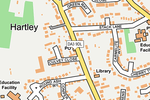
DA3 9DL is located in the Hartley and Hodsoll Street electoral ward, within the local authority district of Sevenoaks and the English Parliamentary constituency of Dartford. The Sub Integrated Care Board (ICB) Location is NHS Kent and Medway ICB - 91Q and the police force is Kent. This postcode has been in use since October 2014.


GetTheData
Source: OS OpenMap – Local (Ordnance Survey)
Source: OS VectorMap District (Ordnance Survey)
Licence: Open Government Licence (requires attribution)
| Easting | 560459 |
| Northing | 167591 |
| Latitude | 51.384686 |
| Longitude | 0.304532 |
GetTheData
Source: Open Postcode Geo
Licence: Open Government Licence
| Country | England |
| Postcode District | DA3 |
| ➜ DA3 open data dashboard ➜ See where DA3 is on a map ➜ Where is Hartley? | |
GetTheData
Source: Land Registry Price Paid Data
Licence: Open Government Licence
Elevation or altitude of DA3 9DL as distance above sea level:
| Metres | Feet | |
|---|---|---|
| Elevation | 100m | 328ft |
Elevation is measured from the approximate centre of the postcode, to the nearest point on an OS contour line from OS Terrain 50, which has contour spacing of ten vertical metres.
➜ How high above sea level am I? Find the elevation of your current position using your device's GPS.
GetTheData
Source: Open Postcode Elevation
Licence: Open Government Licence
| Ward | Hartley And Hodsoll Street |
| Constituency | Dartford |
GetTheData
Source: ONS Postcode Database
Licence: Open Government Licence
| June 2022 | Public order | On or near Cherry Trees | 342m |
| June 2022 | Anti-social behaviour | On or near Cherry Trees | 342m |
| June 2022 | Criminal damage and arson | On or near Old Downs | 356m |
| ➜ Get more crime data in our Crime section | |||
GetTheData
Source: data.police.uk
Licence: Open Government Licence
| Post Office (Ash Road) | Hartley | 9m |
| Green Way (Ash Road) | Hartley | 97m |
| Green Way (Ash Road) | Hartley | 223m |
| Church Road Shops (Church Road) | Hartley | 296m |
| Church Road Shops (Church Road) | Hartley | 321m |
| Longfield Station | 1.3km |
| Meopham Station | 3.7km |
| Farningham Road Station | 5.2km |
GetTheData
Source: NaPTAN
Licence: Open Government Licence
GetTheData
Source: ONS Postcode Database
Licence: Open Government Licence


➜ Get more ratings from the Food Standards Agency
GetTheData
Source: Food Standards Agency
Licence: FSA terms & conditions
| Last Collection | |||
|---|---|---|---|
| Location | Mon-Fri | Sat | Distance |
| Hartley Post Office | 17:00 | 12:00 | 10m |
| Stack Lane | 17:00 | 11:15 | 311m |
| Black Lion | 16:00 | 09:00 | 962m |
GetTheData
Source: Dracos
Licence: Creative Commons Attribution-ShareAlike
| Facility | Distance |
|---|---|
| Hartley Country Club Culvey Close, Hartley, Longfield Grass Pitches, Sports Hall, Squash Courts, Outdoor Tennis Courts | 152m |
| Our Lady Of Hartley Catholic Primary School Stack Lane, Hartley, Longfield Grass Pitches | 267m |
| Corinthians Sports Club Valley Road, Fawkham, Longfield Artificial Grass Pitch, Grass Pitches, Golf, Sports Hall | 682m |
GetTheData
Source: Active Places
Licence: Open Government Licence
| School | Phase of Education | Distance |
|---|---|---|
| Our Lady of Hartley Catholic Primary School, Hartley, Longfield Stack Lane, Hartley, Longfield, DA3 8BL | Primary | 267m |
| Hartley Primary Academy Round Ash Way, Hartley, Longfield, DA3 8BT | Primary | 300m |
| Steephill School Off Castle Hill, Fawkham, Longfield, DA3 7BG | Not applicable | 781m |
GetTheData
Source: Edubase
Licence: Open Government Licence
The below table lists the International Territorial Level (ITL) codes (formerly Nomenclature of Territorial Units for Statistics (NUTS) codes) and Local Administrative Units (LAU) codes for DA3 9DL:
| ITL 1 Code | Name |
|---|---|
| TLJ | South East (England) |
| ITL 2 Code | Name |
| TLJ4 | Kent |
| ITL 3 Code | Name |
| TLJ46 | West Kent |
| LAU 1 Code | Name |
| E07000111 | Sevenoaks |
GetTheData
Source: ONS Postcode Directory
Licence: Open Government Licence
The below table lists the Census Output Area (OA), Lower Layer Super Output Area (LSOA), and Middle Layer Super Output Area (MSOA) for DA3 9DL:
| Code | Name | |
|---|---|---|
| OA | E00124085 | |
| LSOA | E01024443 | Sevenoaks 004C |
| MSOA | E02005090 | Sevenoaks 004 |
GetTheData
Source: ONS Postcode Directory
Licence: Open Government Licence
| DA3 8EW | Ash Road | 50m |
| DA3 8EP | Ash Road | 75m |
| DA3 8BS | Culvey Close | 89m |
| DA3 8EH | Ash Road | 94m |
| DA3 8BW | Broomfields | 96m |
| DA3 8EN | Ash Road | 126m |
| DA3 8EL | Ash Road | 137m |
| DA3 8BJ | Green Way | 167m |
| DA3 8BL | Stack Lane | 176m |
| DA3 8BT | Round Ash Way | 177m |
GetTheData
Source: Open Postcode Geo; Land Registry Price Paid Data
Licence: Open Government Licence