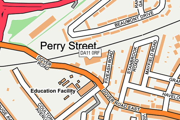
DA11 0RF is located in the Coldharbour & Perry Street electoral ward, within the local authority district of Gravesham and the English Parliamentary constituency of Gravesham. The Sub Integrated Care Board (ICB) Location is NHS Kent and Medway ICB - 91Q and the police force is Kent. This postcode has been in use since January 1980.


GetTheData
Source: OS OpenMap – Local (Ordnance Survey)
Source: OS VectorMap District (Ordnance Survey)
Licence: Open Government Licence (requires attribution)
| Easting | 563494 |
| Northing | 173575 |
| Latitude | 51.437581 |
| Longitude | 0.350865 |
GetTheData
Source: Open Postcode Geo
Licence: Open Government Licence
| Country | England |
| Postcode District | DA11 |
| ➜ DA11 open data dashboard ➜ See where DA11 is on a map ➜ Where is Northfleet? | |
GetTheData
Source: Land Registry Price Paid Data
Licence: Open Government Licence
Elevation or altitude of DA11 0RF as distance above sea level:
| Metres | Feet | |
|---|---|---|
| Elevation | 20m | 66ft |
Elevation is measured from the approximate centre of the postcode, to the nearest point on an OS contour line from OS Terrain 50, which has contour spacing of ten vertical metres.
➜ How high above sea level am I? Find the elevation of your current position using your device's GPS.
GetTheData
Source: Open Postcode Elevation
Licence: Open Government Licence
| Ward | Coldharbour & Perry Street |
| Constituency | Gravesham |
GetTheData
Source: ONS Postcode Database
Licence: Open Government Licence
| January 2024 | Criminal damage and arson | On or near Dudley Road | 393m |
| January 2024 | Violence and sexual offences | On or near Dudley Road | 393m |
| January 2024 | Anti-social behaviour | On or near Supermarket | 402m |
| ➜ Get more crime data in our Crime section | |||
GetTheData
Source: data.police.uk
Licence: Open Government Licence
| Rosherville Way (Thames Way) | Northfleet | 289m |
| Rosherville Way (Thames Way) | Northfleet | 302m |
| The Rose (Pelham Road South) | Perry Street | 411m |
| The Rose (Perry Street) | Perry Street | 424m |
| All Saints Church (Perry Steet) | Perry Street | 431m |
| Gravesend Station | 1.2km |
| Northfleet Station | 2.1km |
| Ebbsfleet International Station | 2.2km |
GetTheData
Source: NaPTAN
Licence: Open Government Licence
GetTheData
Source: ONS Postcode Database
Licence: Open Government Licence


➜ Get more ratings from the Food Standards Agency
GetTheData
Source: Food Standards Agency
Licence: FSA terms & conditions
| Last Collection | |||
|---|---|---|---|
| Location | Mon-Fri | Sat | Distance |
| Five Ash Road | 18:30 | 11:15 | 112m |
| Perry Street Post Office | 17:30 | 11:15 | 411m |
| Pelham Road | 18:30 | 11:15 | 471m |
GetTheData
Source: Dracos
Licence: Creative Commons Attribution-ShareAlike
| Facility | Distance |
|---|---|
| Copperfield Academy Dover Road East, Dover Road East, Gravesend Grass Pitches | 74m |
| Mayfield Grammar School Gravesend Pelham Road, Gravesend Health and Fitness Gym, Sports Hall, Grass Pitches, Outdoor Tennis Courts | 606m |
| Cygnet Leisure Centre Old Perry Street, Northfleet, Gravesend Sports Hall, Swimming Pool, Health and Fitness Gym, Studio, Squash Courts | 710m |
GetTheData
Source: Active Places
Licence: Open Government Licence
| School | Phase of Education | Distance |
|---|---|---|
| Copperfield Academy Dover Road East, Northfleet, Gravesend, DA11 0RB | Primary | 92m |
| St Botolph's Church of England Primary School Dover Road, Northfleet, Gravesend, DA11 9PL | Primary | 551m |
| Northfleet Nursery School 140 London Road, Northfleet, Gravesend, DA11 9JS | Nursery | 584m |
GetTheData
Source: Edubase
Licence: Open Government Licence
The below table lists the International Territorial Level (ITL) codes (formerly Nomenclature of Territorial Units for Statistics (NUTS) codes) and Local Administrative Units (LAU) codes for DA11 0RF:
| ITL 1 Code | Name |
|---|---|
| TLJ | South East (England) |
| ITL 2 Code | Name |
| TLJ4 | Kent |
| ITL 3 Code | Name |
| TLJ43 | Kent Thames Gateway |
| LAU 1 Code | Name |
| E07000109 | Gravesham |
GetTheData
Source: ONS Postcode Directory
Licence: Open Government Licence
The below table lists the Census Output Area (OA), Lower Layer Super Output Area (LSOA), and Middle Layer Super Output Area (MSOA) for DA11 0RF:
| Code | Name | |
|---|---|---|
| OA | E00123289 | |
| LSOA | E01024282 | Gravesham 004C |
| MSOA | E02005058 | Gravesham 004 |
GetTheData
Source: ONS Postcode Directory
Licence: Open Government Licence
| DA11 0RD | Dover Road East | 41m |
| DA11 0RE | Fiveash Road | 76m |
| DA11 9NS | Beaumont Drive | 95m |
| DA11 0RB | Dover Road East | 97m |
| DA11 0JW | Stanbrook Road | 121m |
| DA11 0RA | Dover Road East | 133m |
| DA11 0JN | Stanbrook Road | 146m |
| DA11 9NR | Beaumont Drive | 168m |
| DA11 8DW | Park Avenue | 176m |
| DA11 0JP | Mayfield Road | 183m |
GetTheData
Source: Open Postcode Geo; Land Registry Price Paid Data
Licence: Open Government Licence