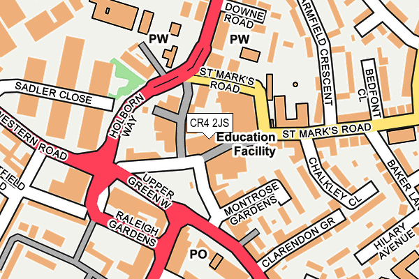
CR4 2JS is located in the Figge's Marsh electoral ward, within the London borough of Merton and the English Parliamentary constituency of Mitcham and Morden. The Sub Integrated Care Board (ICB) Location is NHS South West London ICB - 36L and the police force is Metropolitan Police. This postcode has been in use since September 1991.


GetTheData
Source: OS OpenMap – Local (Ordnance Survey)
Source: OS VectorMap District (Ordnance Survey)
Licence: Open Government Licence (requires attribution)
| Easting | 527836 |
| Northing | 169084 |
| Latitude | 51.406382 |
| Longitude | -0.163431 |
GetTheData
Source: Open Postcode Geo
Licence: Open Government Licence
| Country | England |
| Postcode District | CR4 |
➜ See where CR4 is on a map ➜ Where is London? | |
GetTheData
Source: Land Registry Price Paid Data
Licence: Open Government Licence
Elevation or altitude of CR4 2JS as distance above sea level:
| Metres | Feet | |
|---|---|---|
| Elevation | 20m | 66ft |
Elevation is measured from the approximate centre of the postcode, to the nearest point on an OS contour line from OS Terrain 50, which has contour spacing of ten vertical metres.
➜ How high above sea level am I? Find the elevation of your current position using your device's GPS.
GetTheData
Source: Open Postcode Elevation
Licence: Open Government Licence
| Ward | Figge's Marsh |
| Constituency | Mitcham And Morden |
GetTheData
Source: ONS Postcode Database
Licence: Open Government Licence
| St Mark's Road | Mitcham | 98m |
| Mitcham Fair Green (Upper Green West) | Mitcham | 116m |
| Mitcham Fair Green | Mitcham | 143m |
| Mitcham Fair Green (Upper Green East) | Mitcham | 146m |
| Downe Road Mitcham Library (London Road) | Mitcham | 147m |
| Mitcham Tram Stop (Off London Road) | Mitcham | 1,117m |
| Belgrave Walk Tram Stop (Belgrave Walk) | Morden | 1,209m |
| Phipps Bridge Tram Stop (New Close-phipps Bridge) | Morden | 1,354m |
| Mitcham Junction Tram Stop (Off Carshalton Road) | Mitcham | 1,546m |
| Colliers Wood Underground Station | Collier's Wood | 1,659m |
| Mitcham Eastfields Station | 0.6km |
| Tooting Station | 1.5km |
| Mitcham Junction Station | 1.5km |
GetTheData
Source: NaPTAN
Licence: Open Government Licence
GetTheData
Source: ONS Postcode Database
Licence: Open Government Licence


➜ Get more ratings from the Food Standards Agency
GetTheData
Source: Food Standards Agency
Licence: FSA terms & conditions
| Last Collection | |||
|---|---|---|---|
| Location | Mon-Fri | Sat | Distance |
| Upper Green East (19) | 17:00 | 12:00 | 83m |
| Mitcham Mspo | 17:15 | 12:00 | 164m |
| London Road (175) | 17:00 | 12:00 | 186m |
GetTheData
Source: Dracos
Licence: Creative Commons Attribution-ShareAlike
The below table lists the International Territorial Level (ITL) codes (formerly Nomenclature of Territorial Units for Statistics (NUTS) codes) and Local Administrative Units (LAU) codes for CR4 2JS:
| ITL 1 Code | Name |
|---|---|
| TLI | London |
| ITL 2 Code | Name |
| TLI6 | Outer London - South |
| ITL 3 Code | Name |
| TLI63 | Merton, Kingston upon Thames and Sutton |
| LAU 1 Code | Name |
| E09000024 | Merton |
GetTheData
Source: ONS Postcode Directory
Licence: Open Government Licence
The below table lists the Census Output Area (OA), Lower Layer Super Output Area (LSOA), and Middle Layer Super Output Area (MSOA) for CR4 2JS:
| Code | Name | |
|---|---|---|
| OA | E00017155 | |
| LSOA | E01003390 | Merton 018D |
| MSOA | E02000706 | Merton 018 |
GetTheData
Source: ONS Postcode Directory
Licence: Open Government Licence
| CR4 3HD | London Road | 69m |
| CR4 3NN | Sibthorp Road | 69m |
| CR4 2JD | London Road | 76m |
| CR4 2PE | Upper Green East | 78m |
| CR4 3AA | Upper Green West | 108m |
| CR4 3NA | London Road | 127m |
| CR4 2PJ | Montrose Gardens | 133m |
| CR4 2PG | Montrose Gardens | 141m |
| CR4 3FG | Holborn Way | 151m |
| CR4 2PF | Upper Green East | 159m |
GetTheData
Source: Open Postcode Geo; Land Registry Price Paid Data
Licence: Open Government Licence