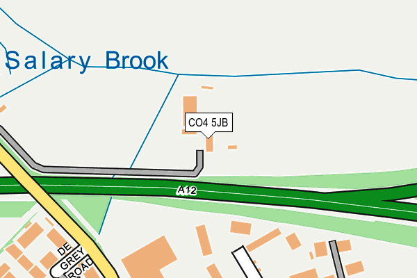
CO4 5JB is located in the Highwoods electoral ward, within the local authority district of Colchester and the English Parliamentary constituency of Colchester. The Sub Integrated Care Board (ICB) Location is NHS Suffolk and North East Essex ICB - 06T and the police force is Essex. This postcode has been in use since August 2008.


GetTheData
Source: OS OpenMap – Local (Ordnance Survey)
Source: OS VectorMap District (Ordnance Survey)
Licence: Open Government Licence (requires attribution)
| Easting | 600905 |
| Northing | 229309 |
| Latitude | 51.926032 |
| Longitude | 0.920483 |
GetTheData
Source: Open Postcode Geo
Licence: Open Government Licence
| Country | England |
| Postcode District | CO4 |
| ➜ CO4 open data dashboard ➜ See where CO4 is on a map | |
GetTheData
Source: Land Registry Price Paid Data
Licence: Open Government Licence
Elevation or altitude of CO4 5JB as distance above sea level:
| Metres | Feet | |
|---|---|---|
| Elevation | 40m | 131ft |
Elevation is measured from the approximate centre of the postcode, to the nearest point on an OS contour line from OS Terrain 50, which has contour spacing of ten vertical metres.
➜ How high above sea level am I? Find the elevation of your current position using your device's GPS.
GetTheData
Source: Open Postcode Elevation
Licence: Open Government Licence
| Ward | Highwoods |
| Constituency | Colchester |
GetTheData
Source: ONS Postcode Database
Licence: Open Government Licence
| June 2022 | Violence and sexual offences | On or near De Grey Road | 269m |
| June 2022 | Violence and sexual offences | On or near De Grey Road | 269m |
| June 2022 | Criminal damage and arson | On or near De Grey Road | 269m |
| ➜ Get more crime data in our Crime section | |||
GetTheData
Source: data.police.uk
Licence: Open Government Licence
| Cuckoo Point (Severalls Lane) | Severalls Park | 290m |
| Office Village (The Crescent) | Severalls Park | 309m |
| Cuckoo Point (Severalls Lane) | Severalls Park | 310m |
| Office Village (The Crescent) | Severalls Park | 337m |
| New Link Road East (Axial Way) | Mile End | 406m |
| Colchester Station | 3.4km |
| Hythe (Essex) Station | 4.5km |
| Colchester Town Station | 4.5km |
GetTheData
Source: NaPTAN
Licence: Open Government Licence
GetTheData
Source: ONS Postcode Database
Licence: Open Government Licence


➜ Get more ratings from the Food Standards Agency
GetTheData
Source: Food Standards Agency
Licence: FSA terms & conditions
| Last Collection | |||
|---|---|---|---|
| Location | Mon-Fri | Sat | Distance |
| Lion And Lamb | 17:00 | 10:30 | 1,186m |
| Crown Lane Ardleigh | 16:00 | 10:30 | 1,302m |
| Chinook Highwoods | 17:30 | 11:30 | 1,585m |
GetTheData
Source: Dracos
Licence: Creative Commons Attribution-ShareAlike
| Facility | Distance |
|---|---|
| Royal London Insurance Sports Ground (Closed) Mill Road, Mile End, Colchester Grass Pitches | 518m |
| Crossfit Colchester Heckworth Close, Severalls Industrial Park, Colchester Health and Fitness Gym | 748m |
| Mill Road Playing Fields Mill Road, Mile End, Colchester Grass Pitches | 906m |
GetTheData
Source: Active Places
Licence: Open Government Licence
| School | Phase of Education | Distance |
|---|---|---|
| Brinkley Grove Primary School Rawlings Crescent, Highwoods, Colchester, CO4 9GF | Primary | 1.1km |
| The Trinity School Carris Close, Colchester, CO4 6ED | Secondary | 1.1km |
| The Gilberd School Brinkley Lane, Colchester, CO4 9PU | Secondary | 1.2km |
GetTheData
Source: Edubase
Licence: Open Government Licence
The below table lists the International Territorial Level (ITL) codes (formerly Nomenclature of Territorial Units for Statistics (NUTS) codes) and Local Administrative Units (LAU) codes for CO4 5JB:
| ITL 1 Code | Name |
|---|---|
| TLH | East |
| ITL 2 Code | Name |
| TLH3 | Essex |
| ITL 3 Code | Name |
| TLH34 | Essex Haven Gateway |
| LAU 1 Code | Name |
| E07000071 | Colchester |
GetTheData
Source: ONS Postcode Directory
Licence: Open Government Licence
The below table lists the Census Output Area (OA), Lower Layer Super Output Area (LSOA), and Middle Layer Super Output Area (MSOA) for CO4 5JB:
| Code | Name | |
|---|---|---|
| OA | E00110069 | |
| LSOA | E01033720 | Colchester 002F |
| MSOA | E02004507 | Colchester 002 |
GetTheData
Source: ONS Postcode Directory
Licence: Open Government Licence
| CO4 9QB | The Crescent | 245m |
| CO4 9YQ | The Crescent | 261m |
| CO4 5YE | De Grey Road | 265m |
| CO4 5TZ | St James Place | 296m |
| CO4 5YQ | De Grey Square | 319m |
| CO4 5BD | Hale Way | 356m |
| CO4 5BE | Parker Road | 381m |
| CO4 5AN | Matchett Drive | 403m |
| CO4 5ZJ | Chapman Place | 436m |
| CO4 5ZH | Roper Close | 470m |
GetTheData
Source: Open Postcode Geo; Land Registry Price Paid Data
Licence: Open Government Licence