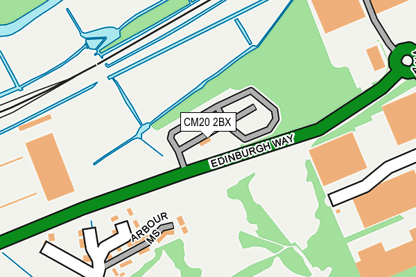
CM20 2BX is located in the Netteswell electoral ward, within the local authority district of Harlow and the English Parliamentary constituency of Harlow. The Sub Integrated Care Board (ICB) Location is NHS Hertfordshire and West Essex ICB - 07H and the police force is Essex. This postcode has been in use since March 2006.


GetTheData
Source: OS OpenMap – Local (Ordnance Survey)
Source: OS VectorMap District (Ordnance Survey)
Licence: Open Government Licence (requires attribution)
| Easting | 545184 |
| Northing | 211318 |
| Latitude | 51.781697 |
| Longitude | 0.103251 |
GetTheData
Source: Open Postcode Geo
Licence: Open Government Licence
| Country | England |
| Postcode District | CM20 |
| ➜ CM20 open data dashboard ➜ See where CM20 is on a map ➜ Where is Harlow? | |
GetTheData
Source: Land Registry Price Paid Data
Licence: Open Government Licence
Elevation or altitude of CM20 2BX as distance above sea level:
| Metres | Feet | |
|---|---|---|
| Elevation | 40m | 131ft |
Elevation is measured from the approximate centre of the postcode, to the nearest point on an OS contour line from OS Terrain 50, which has contour spacing of ten vertical metres.
➜ How high above sea level am I? Find the elevation of your current position using your device's GPS.
GetTheData
Source: Open Postcode Elevation
Licence: Open Government Licence
| Ward | Netteswell |
| Constituency | Harlow |
GetTheData
Source: ONS Postcode Database
Licence: Open Government Licence
| November 2023 | Anti-social behaviour | On or near Parking Area | 437m |
| November 2023 | Vehicle crime | On or near Parking Area | 437m |
| November 2023 | Public order | On or near Parking Area | 437m |
| ➜ Get more crime data in our Crime section | |||
GetTheData
Source: data.police.uk
Licence: Open Government Licence
| Howard Way (Edinburgh Way) | Harlow | 221m |
| Princes Gate (Howard Way) | Harlow | 402m |
| Queensgate Centre (Edinburgh Way) | Harlow | 561m |
| Queensgate Centre (Edinburgh Way) | Harlow | 580m |
| Town Railway Station (Station Approach) | Harlow | 587m |
| Harlow Town Station | 0.6km |
| Harlow Mill Station | 2.2km |
| Roydon Station | 4.7km |
GetTheData
Source: NaPTAN
Licence: Open Government Licence
GetTheData
Source: ONS Postcode Database
Licence: Open Government Licence


➜ Get more ratings from the Food Standards Agency
GetTheData
Source: Food Standards Agency
Licence: FSA terms & conditions
| Last Collection | |||
|---|---|---|---|
| Location | Mon-Fri | Sat | Distance |
| Pittmans Field | 17:45 | 12:00 | 719m |
| River Mill | 17:15 | 12:00 | 1,103m |
| Rectory Wood | 17:15 | 12:00 | 1,443m |
GetTheData
Source: Dracos
Licence: Creative Commons Attribution-ShareAlike
| Facility | Distance |
|---|---|
| Burnt Mill Academy First Avenue, Harlow Grass Pitches, Health and Fitness Gym, Sports Hall, Swimming Pool, Studio | 518m |
| Anytime Fitness (Harlow) Edinburgh Gate, Harlow Health and Fitness Gym, Studio | 537m |
| Harlow Pool And Fitness Centre (Closed) First Avenue, Harlow Studio, Swimming Pool, Health and Fitness Gym | 830m |
GetTheData
Source: Active Places
Licence: Open Government Licence
| School | Phase of Education | Distance |
|---|---|---|
| Burnt Mill Academy First Avenue, Harlow, CM20 2NR | Secondary | 630m |
| St Alban's Catholic Academy First Avenue, Harlow, CM20 2NP | Primary | 683m |
| Freshwaters Primary Academy School Lane, Harlow, CM20 3QA | Primary | 1km |
GetTheData
Source: Edubase
Licence: Open Government Licence
The below table lists the International Territorial Level (ITL) codes (formerly Nomenclature of Territorial Units for Statistics (NUTS) codes) and Local Administrative Units (LAU) codes for CM20 2BX:
| ITL 1 Code | Name |
|---|---|
| TLH | East |
| ITL 2 Code | Name |
| TLH3 | Essex |
| ITL 3 Code | Name |
| TLH35 | West Essex |
| LAU 1 Code | Name |
| E07000073 | Harlow |
GetTheData
Source: ONS Postcode Directory
Licence: Open Government Licence
The below table lists the Census Output Area (OA), Lower Layer Super Output Area (LSOA), and Middle Layer Super Output Area (MSOA) for CM20 2BX:
| Code | Name | |
|---|---|---|
| OA | E00111006 | |
| LSOA | E01021853 | Harlow 003E |
| MSOA | E02004546 | Harlow 003 |
GetTheData
Source: ONS Postcode Directory
Licence: Open Government Licence
| CM20 2FL | Arbour Mews | 168m |
| CM20 2QF | Marshgate | 173m |
| CM20 2QE | Rushmead Villas | 238m |
| CM20 2SU | Howard Way | 285m |
| CM20 2QD | School Lane | 287m |
| CM20 2PN | Altham Grove | 431m |
| CM20 2FZ | Bowlby Hill | 481m |
| CM20 2PW | Altham Grove | 486m |
| CM20 2PH | Altham Grove | 506m |
| CM20 2PL | Altham Grove | 531m |
GetTheData
Source: Open Postcode Geo; Land Registry Price Paid Data
Licence: Open Government Licence