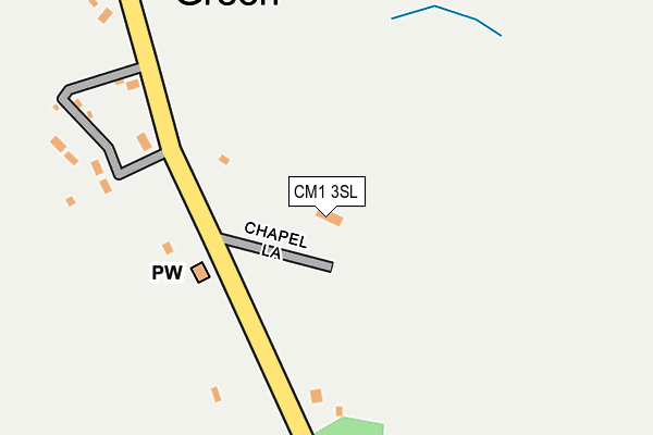
CM1 3SL lies on Chapel Lane in Cooksmill Green, Chelmsford. CM1 3SL is located in the Chelmsford Rural West electoral ward, within the local authority district of Chelmsford and the English Parliamentary constituency of Saffron Walden. The Sub Integrated Care Board (ICB) Location is NHS Mid and South Essex ICB - 06Q and the police force is Essex. This postcode has been in use since January 1980.


GetTheData
Source: OS OpenMap – Local (Ordnance Survey)
Source: OS VectorMap District (Ordnance Survey)
Licence: Open Government Licence (requires attribution)
| Easting | 563920 |
| Northing | 206290 |
| Latitude | 51.731359 |
| Longitude | 0.372250 |
GetTheData
Source: Open Postcode Geo
Licence: Open Government Licence
| Street | Chapel Lane |
| Locality | Cooksmill Green |
| Town/City | Chelmsford |
| Country | England |
| Postcode District | CM1 |
➜ See where CM1 is on a map ➜ Where is Cooksmill Green? | |
GetTheData
Source: Land Registry Price Paid Data
Licence: Open Government Licence
Elevation or altitude of CM1 3SL as distance above sea level:
| Metres | Feet | |
|---|---|---|
| Elevation | 70m | 230ft |
Elevation is measured from the approximate centre of the postcode, to the nearest point on an OS contour line from OS Terrain 50, which has contour spacing of ten vertical metres.
➜ How high above sea level am I? Find the elevation of your current position using your device's GPS.
GetTheData
Source: Open Postcode Elevation
Licence: Open Government Licence
| Ward | Chelmsford Rural West |
| Constituency | Saffron Walden |
GetTheData
Source: ONS Postcode Database
Licence: Open Government Licence
| Wyse's Road (Ongar Road) | Highwood | 1,002m |
| Wyse's Road (Ongar Road) | Highwood | 1,047m |
GetTheData
Source: NaPTAN
Licence: Open Government Licence
| Percentage of properties with Next Generation Access | 100.0% |
| Percentage of properties with Superfast Broadband | 100.0% |
| Percentage of properties with Ultrafast Broadband | 0.0% |
| Percentage of properties with Full Fibre Broadband | 0.0% |
Superfast Broadband is between 30Mbps and 300Mbps
Ultrafast Broadband is > 300Mbps
| Percentage of properties unable to receive 2Mbps | 0.0% |
| Percentage of properties unable to receive 5Mbps | 0.0% |
| Percentage of properties unable to receive 10Mbps | 0.0% |
| Percentage of properties unable to receive 30Mbps | 0.0% |
GetTheData
Source: Ofcom
Licence: Ofcom Terms of Use (requires attribution)
GetTheData
Source: ONS Postcode Database
Licence: Open Government Licence


➜ Get more ratings from the Food Standards Agency
GetTheData
Source: Food Standards Agency
Licence: FSA terms & conditions
| Last Collection | |||
|---|---|---|---|
| Location | Mon-Fri | Sat | Distance |
| Long Brandocks | 16:50 | 08:45 | 3,455m |
| Writtle P.o. | 17:30 | 12:00 | 3,897m |
| Lodge Road | 16:45 | 09:00 | 3,906m |
GetTheData
Source: Dracos
Licence: Creative Commons Attribution-ShareAlike
The below table lists the International Territorial Level (ITL) codes (formerly Nomenclature of Territorial Units for Statistics (NUTS) codes) and Local Administrative Units (LAU) codes for CM1 3SL:
| ITL 1 Code | Name |
|---|---|
| TLH | East |
| ITL 2 Code | Name |
| TLH3 | Essex |
| ITL 3 Code | Name |
| TLH36 | Heart of Essex |
| LAU 1 Code | Name |
| E07000070 | Chelmsford |
GetTheData
Source: ONS Postcode Directory
Licence: Open Government Licence
The below table lists the Census Output Area (OA), Lower Layer Super Output Area (LSOA), and Middle Layer Super Output Area (MSOA) for CM1 3SL:
| Code | Name | |
|---|---|---|
| OA | E00109478 | |
| LSOA | E01021551 | Chelmsford 011A |
| MSOA | E02004495 | Chelmsford 011 |
GetTheData
Source: ONS Postcode Directory
Licence: Open Government Licence
| CM1 3SH | 127m | |
| CM1 3SJ | 592m | |
| CM1 3SP | Ongar Road | 1010m |
| CM1 4NP | Stonehill Road | 1015m |
| CM1 3SN | Wyses Road | 1078m |
| CM1 3SF | 1354m | |
| CM1 3SG | Gravelly Lane | 1408m |
| CM1 3SE | Moor Hall Cottages | 1435m |
| CM4 0LU | 1729m | |
| CM1 4NS | Stonehill Road | 1838m |
GetTheData
Source: Open Postcode Geo; Land Registry Price Paid Data
Licence: Open Government Licence