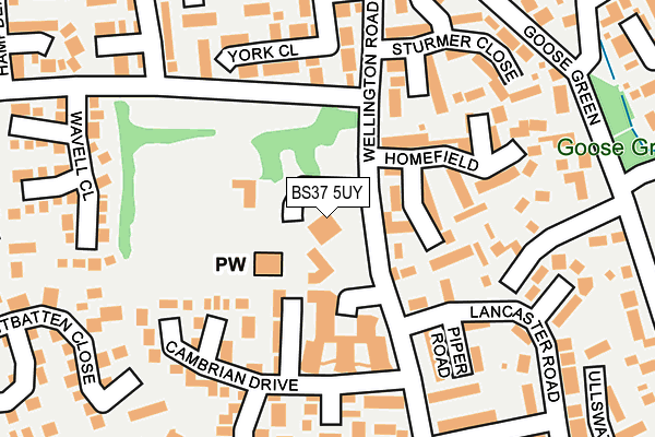
BS37 5UY is located in the Yate North electoral ward, within the unitary authority of South Gloucestershire and the English Parliamentary constituency of Thornbury and Yate. The Sub Integrated Care Board (ICB) Location is NHS Bristol, North Somerset and South Gloucestershire ICB - 15C and the police force is Avon and Somerset. This postcode has been in use since December 1997.


GetTheData
Source: OS OpenMap – Local (Ordnance Survey)
Source: OS VectorMap District (Ordnance Survey)
Licence: Open Government Licence (requires attribution)
| Easting | 371129 |
| Northing | 183418 |
| Latitude | 51.548908 |
| Longitude | -2.417761 |
GetTheData
Source: Open Postcode Geo
Licence: Open Government Licence
| Country | England |
| Postcode District | BS37 |
| ➜ BS37 open data dashboard ➜ See where BS37 is on a map ➜ Where is Yate? | |
GetTheData
Source: Land Registry Price Paid Data
Licence: Open Government Licence
Elevation or altitude of BS37 5UY as distance above sea level:
| Metres | Feet | |
|---|---|---|
| Elevation | 80m | 262ft |
Elevation is measured from the approximate centre of the postcode, to the nearest point on an OS contour line from OS Terrain 50, which has contour spacing of ten vertical metres.
➜ How high above sea level am I? Find the elevation of your current position using your device's GPS.
GetTheData
Source: Open Postcode Elevation
Licence: Open Government Licence
| Ward | Yate North |
| Constituency | Thornbury And Yate |
GetTheData
Source: ONS Postcode Database
Licence: Open Government Licence
| April 2023 | Bicycle theft | On or near Crowthers Avenue | 396m |
| February 2023 | Violence and sexual offences | On or near Cheshire Close | 265m |
| November 2022 | Violence and sexual offences | On or near Cheshire Close | 265m |
| ➜ Get more crime data in our Crime section | |||
GetTheData
Source: data.police.uk
Licence: Open Government Licence
| The Farmhouse (Wellington Road) | Yate | 48m |
| The Farmhouse (Wellington Road) | Yate | 67m |
| Sturmer Close (Wellington Road) | Yate | 159m |
| Sturmer Close (Wellington Road) | Yate | 210m |
| Lancaster Road (Wellington Road) | Yate | 226m |
| Yate Station | 1.4km |
GetTheData
Source: NaPTAN
Licence: Open Government Licence
GetTheData
Source: ONS Postcode Database
Licence: Open Government Licence


➜ Get more ratings from the Food Standards Agency
GetTheData
Source: Food Standards Agency
Licence: FSA terms & conditions
| Last Collection | |||
|---|---|---|---|
| Location | Mon-Fri | Sat | Distance |
| Goose Green | 17:15 | 08:00 | 264m |
| Greenways Road | 17:00 | 09:00 | 325m |
| Brinmsham Park | 16:30 | 09:30 | 394m |
GetTheData
Source: Dracos
Licence: Creative Commons Attribution-ShareAlike
| Facility | Distance |
|---|---|
| Brimsham Green School Broad Lane, Yate, Bristol Grass Pitches, Sports Hall, Studio | 590m |
| Yate Outdoor Sports Complex Broad Lane, Yate, Bristol Athletics, Grass Pitches, Artificial Grass Pitch, Sports Hall | 673m |
| Yate Active Lifestyle Centre Kennedy Way, Yate, Bristol Sports Hall, Indoor Bowls, Swimming Pool, Health and Fitness Gym, Studio, Squash Courts | 946m |
GetTheData
Source: Active Places
Licence: Open Government Licence
| School | Phase of Education | Distance |
|---|---|---|
| Tyndale Primary School Tyndale Avenue, Yate, BS37 5EX | Primary | 496m |
| Brimsham Green School Broad Lane, Yate, Bristol, BS37 7LB | Secondary | 648m |
| St Mary's Church of England Primary School, Yate Church Road, Yate, Bristol, BS37 5BG | Primary | 724m |
GetTheData
Source: Edubase
Licence: Open Government Licence
The below table lists the International Territorial Level (ITL) codes (formerly Nomenclature of Territorial Units for Statistics (NUTS) codes) and Local Administrative Units (LAU) codes for BS37 5UY:
| ITL 1 Code | Name |
|---|---|
| TLK | South West (England) |
| ITL 2 Code | Name |
| TLK1 | Gloucestershire, Wiltshire and Bath/Bristol area |
| ITL 3 Code | Name |
| TLK12 | Bath and North East Somerset, North Somerset and South Gloucestershire |
| LAU 1 Code | Name |
| E06000025 | South Gloucestershire |
GetTheData
Source: ONS Postcode Directory
Licence: Open Government Licence
The below table lists the Census Output Area (OA), Lower Layer Super Output Area (LSOA), and Middle Layer Super Output Area (MSOA) for BS37 5UY:
| Code | Name | |
|---|---|---|
| OA | E00075877 | |
| LSOA | E01015021 | South Gloucestershire 007C |
| MSOA | E02003096 | South Gloucestershire 007 |
GetTheData
Source: ONS Postcode Directory
Licence: Open Government Licence
| BS37 5US | Homefield | 123m |
| BS37 5TT | Cambrian Drive | 127m |
| BS37 5XA | York Close | 145m |
| BS37 5SY | Piper Road | 168m |
| BS37 5TR | Cambrian Drive | 187m |
| BS37 5UR | Sturmer Close | 188m |
| BS37 5TS | Cambrian Drive | 192m |
| BS37 5SX | Lancaster Road | 196m |
| BS37 5XB | York Close | 199m |
| BS37 5UL | Wavell Close | 209m |
GetTheData
Source: Open Postcode Geo; Land Registry Price Paid Data
Licence: Open Government Licence