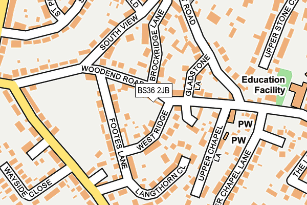
BS36 2JB lies on Woodend Road in Frampton Cotterell, Bristol. BS36 2JB is located in the Frampton Cotterell electoral ward, within the unitary authority of South Gloucestershire and the English Parliamentary constituency of Thornbury and Yate. The Sub Integrated Care Board (ICB) Location is NHS Bristol, North Somerset and South Gloucestershire ICB - 15C and the police force is Avon and Somerset. This postcode has been in use since December 1997.


GetTheData
Source: OS OpenMap – Local (Ordnance Survey)
Source: OS VectorMap District (Ordnance Survey)
Licence: Open Government Licence (requires attribution)
| Easting | 367029 |
| Northing | 181306 |
| Latitude | 51.529693 |
| Longitude | -2.476689 |
GetTheData
Source: Open Postcode Geo
Licence: Open Government Licence
| Street | Woodend Road |
| Locality | Frampton Cotterell |
| Town/City | Bristol |
| Country | England |
| Postcode District | BS36 |
➜ See where BS36 is on a map ➜ Where is Frampton Cotterell? | |
GetTheData
Source: Land Registry Price Paid Data
Licence: Open Government Licence
Elevation or altitude of BS36 2JB as distance above sea level:
| Metres | Feet | |
|---|---|---|
| Elevation | 70m | 230ft |
Elevation is measured from the approximate centre of the postcode, to the nearest point on an OS contour line from OS Terrain 50, which has contour spacing of ten vertical metres.
➜ How high above sea level am I? Find the elevation of your current position using your device's GPS.
GetTheData
Source: Open Postcode Elevation
Licence: Open Government Licence
| Ward | Frampton Cotterell |
| Constituency | Thornbury And Yate |
GetTheData
Source: ONS Postcode Database
Licence: Open Government Licence
| Hillside Close (Lower Chapel Lane) | Frampton Cotterell | 216m |
| Lower Stone Close | Frampton Cotterell | 231m |
| The Golden Lion (Woodend Road) | Frampton Cotterell | 316m |
| Sunnyside (Park Lane) | Frampton Cotterell | 325m |
| The Rising Sun (Ryecroft Road) | Frampton Cotterell | 343m |
| Yate Station | 3.3km |
| Bristol Parkway Station | 4.9km |
GetTheData
Source: NaPTAN
Licence: Open Government Licence
| Percentage of properties with Next Generation Access | 100.0% |
| Percentage of properties with Superfast Broadband | 100.0% |
| Percentage of properties with Ultrafast Broadband | 100.0% |
| Percentage of properties with Full Fibre Broadband | 0.0% |
Superfast Broadband is between 30Mbps and 300Mbps
Ultrafast Broadband is > 300Mbps
| Percentage of properties unable to receive 2Mbps | 0.0% |
| Percentage of properties unable to receive 5Mbps | 0.0% |
| Percentage of properties unable to receive 10Mbps | 0.0% |
| Percentage of properties unable to receive 30Mbps | 0.0% |
GetTheData
Source: Ofcom
Licence: Ofcom Terms of Use (requires attribution)
GetTheData
Source: ONS Postcode Database
Licence: Open Government Licence

➜ Get more ratings from the Food Standards Agency
GetTheData
Source: Food Standards Agency
Licence: FSA terms & conditions
| Last Collection | |||
|---|---|---|---|
| Location | Mon-Fri | Sat | Distance |
| Brockeridge | 16:00 | 07:00 | 165m |
| Woodend Road | 16:00 | 09:00 | 322m |
| Frampton Cotterell Post Office | 17:30 | 12:00 | 446m |
GetTheData
Source: Dracos
Licence: Creative Commons Attribution-ShareAlike
The below table lists the International Territorial Level (ITL) codes (formerly Nomenclature of Territorial Units for Statistics (NUTS) codes) and Local Administrative Units (LAU) codes for BS36 2JB:
| ITL 1 Code | Name |
|---|---|
| TLK | South West (England) |
| ITL 2 Code | Name |
| TLK1 | Gloucestershire, Wiltshire and Bath/Bristol area |
| ITL 3 Code | Name |
| TLK12 | Bath and North East Somerset, North Somerset and South Gloucestershire |
| LAU 1 Code | Name |
| E06000025 | South Gloucestershire |
GetTheData
Source: ONS Postcode Directory
Licence: Open Government Licence
The below table lists the Census Output Area (OA), Lower Layer Super Output Area (LSOA), and Middle Layer Super Output Area (MSOA) for BS36 2JB:
| Code | Name | |
|---|---|---|
| OA | E00075349 | |
| LSOA | E01014913 | South Gloucestershire 013C |
| MSOA | E02003102 | South Gloucestershire 013 |
GetTheData
Source: ONS Postcode Directory
Licence: Open Government Licence
| BS36 2JA | West Ridge | 77m |
| BS36 2HZ | Hillside Lane | 83m |
| BS36 2HX | Woodend Road | 93m |
| BS36 2JD | Woodend Road | 97m |
| BS36 2HR | Gladstone Lane | 101m |
| BS36 2JG | Footes Lane | 106m |
| BS36 2HY | Upper Chapel Lane | 122m |
| BS36 2HU | Brockridge Lane | 127m |
| BS36 2JQ | Footes Lane | 135m |
| BS36 2JH | Langthorn Close | 141m |
GetTheData
Source: Open Postcode Geo; Land Registry Price Paid Data
Licence: Open Government Licence