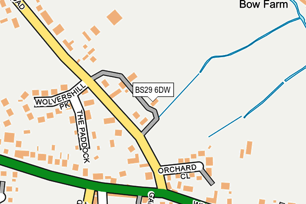
BS29 6DW is located in the Banwell & Winscombe electoral ward, within the unitary authority of North Somerset and the English Parliamentary constituency of Weston-Super-Mare. The Sub Integrated Care Board (ICB) Location is NHS Bristol, North Somerset and South Gloucestershire ICB - 15C and the police force is Avon and Somerset. This postcode has been in use since December 1997.


GetTheData
Source: OS OpenMap – Local (Ordnance Survey)
Source: OS VectorMap District (Ordnance Survey)
Licence: Open Government Licence (requires attribution)
| Easting | 339542 |
| Northing | 159409 |
| Latitude | 51.330548 |
| Longitude | -2.869146 |
GetTheData
Source: Open Postcode Geo
Licence: Open Government Licence
| Country | England |
| Postcode District | BS29 |
| ➜ BS29 open data dashboard ➜ See where BS29 is on a map ➜ Where is Banwell? | |
GetTheData
Source: Land Registry Price Paid Data
Licence: Open Government Licence
Elevation or altitude of BS29 6DW as distance above sea level:
| Metres | Feet | |
|---|---|---|
| Elevation | 10m | 33ft |
Elevation is measured from the approximate centre of the postcode, to the nearest point on an OS contour line from OS Terrain 50, which has contour spacing of ten vertical metres.
➜ How high above sea level am I? Find the elevation of your current position using your device's GPS.
GetTheData
Source: Open Postcode Elevation
Licence: Open Government Licence
| Ward | Banwell & Winscombe |
| Constituency | Weston-super-mare |
GetTheData
Source: ONS Postcode Database
Licence: Open Government Licence
COUNTRY VIEW, GODING LANE, BANWELL, BS29 6DW 2022 29 JUL £645,000 |
GetTheData
Source: HM Land Registry Price Paid Data
Licence: Contains HM Land Registry data © Crown copyright and database right 2024. This data is licensed under the Open Government Licence v3.0.
| June 2022 | Public order | On or near Orchard Close | 138m |
| June 2022 | Other theft | On or near Orchard Close | 138m |
| June 2022 | Public order | On or near West Street | 307m |
| ➜ Get more crime data in our Crime section | |||
GetTheData
Source: data.police.uk
Licence: Open Government Licence
| Wolvershill Park | Banwell | 107m |
| Orchard Close | Banwell | 132m |
| Orchard Close | Banwell | 156m |
| The Orchard | Banwell | 227m |
| Westfield Crescent (A371) | Banwell | 240m |
| Worle Station | 4.2km |
GetTheData
Source: NaPTAN
Licence: Open Government Licence
| Percentage of properties with Next Generation Access | 100.0% |
| Percentage of properties with Superfast Broadband | 100.0% |
| Percentage of properties with Ultrafast Broadband | 0.0% |
| Percentage of properties with Full Fibre Broadband | 0.0% |
Superfast Broadband is between 30Mbps and 300Mbps
Ultrafast Broadband is > 300Mbps
| Percentage of properties unable to receive 2Mbps | 0.0% |
| Percentage of properties unable to receive 5Mbps | 0.0% |
| Percentage of properties unable to receive 10Mbps | 0.0% |
| Percentage of properties unable to receive 30Mbps | 0.0% |
GetTheData
Source: Ofcom
Licence: Ofcom Terms of Use (requires attribution)
GetTheData
Source: ONS Postcode Database
Licence: Open Government Licence


➜ Get more ratings from the Food Standards Agency
GetTheData
Source: Food Standards Agency
Licence: FSA terms & conditions
| Last Collection | |||
|---|---|---|---|
| Location | Mon-Fri | Sat | Distance |
| Banwell Post Office | 17:00 | 12:30 | 364m |
| High Street | 16:15 | 07:45 | 548m |
| Castle Hill | 17:30 | 08:45 | 955m |
GetTheData
Source: Dracos
Licence: Creative Commons Attribution-ShareAlike
| Facility | Distance |
|---|---|
| Banwell Primary School West Street, Banwell Sports Hall, Grass Pitches | 330m |
| Banwell Football Club (1 Of 3) Riverside, Banwell Grass Pitches | 490m |
| Banwell Football Club (2 Of 3) Riverside, Banwell Grass Pitches | 657m |
GetTheData
Source: Active Places
Licence: Open Government Licence
| School | Phase of Education | Distance |
|---|---|---|
| Banwell Primary School West Street, Banwell, BS29 6DB | Primary | 319m |
| Parklands Educate Together Primary 1 Russell Road, Locking, Weston-Super-Mare, BS24 7NH | Primary | 2.8km |
| Locking Primary School Meadow Drive, Locking, Weston-Super-Mare, BS24 8BB | Primary | 2.9km |
GetTheData
Source: Edubase
Licence: Open Government Licence
The below table lists the International Territorial Level (ITL) codes (formerly Nomenclature of Territorial Units for Statistics (NUTS) codes) and Local Administrative Units (LAU) codes for BS29 6DW:
| ITL 1 Code | Name |
|---|---|
| TLK | South West (England) |
| ITL 2 Code | Name |
| TLK1 | Gloucestershire, Wiltshire and Bath/Bristol area |
| ITL 3 Code | Name |
| TLK12 | Bath and North East Somerset, North Somerset and South Gloucestershire |
| LAU 1 Code | Name |
| E06000024 | North Somerset |
GetTheData
Source: ONS Postcode Directory
Licence: Open Government Licence
The below table lists the Census Output Area (OA), Lower Layer Super Output Area (LSOA), and Middle Layer Super Output Area (MSOA) for BS29 6DW:
| Code | Name | |
|---|---|---|
| OA | E00074466 | |
| LSOA | E01032666 | North Somerset 026B |
| MSOA | E02006845 | North Somerset 026 |
GetTheData
Source: ONS Postcode Directory
Licence: Open Government Licence
| BS29 6DG | Wolvershill Road | 95m |
| BS29 6DF | Orchard Close | 160m |
| BS29 6DH | The Paddock | 163m |
| BS29 6DE | West Street | 193m |
| BS29 6DQ | Wolvershill Park | 211m |
| BS29 6BT | Emmerson Terrace | 220m |
| BS29 6DD | Gables Close | 259m |
| BS29 6DB | West Street | 285m |
| BS29 6DJ | Wolvershill Road | 292m |
| BS29 6HA | Knightcott Road | 305m |
GetTheData
Source: Open Postcode Geo; Land Registry Price Paid Data
Licence: Open Government Licence