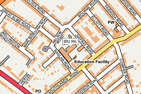
BR2 9NL is located in the Bromley Common & Holwood electoral ward, within the London borough of Bromley and the English Parliamentary constituency of Bromley and Chislehurst. The Sub Integrated Care Board (ICB) Location is NHS South East London ICB - 72Q and the police force is Metropolitan Police. This postcode has been in use since January 1980.


GetTheData
Source: OS OpenMap – Local (Ordnance Survey)
Source: OS VectorMap District (Ordnance Survey)
Licence: Open Government Licence (requires attribution)
| Easting | 541518 |
| Northing | 168161 |
| Latitude | 51.394843 |
| Longitude | 0.032758 |
GetTheData
Source: Open Postcode Geo
Licence: Open Government Licence
| Country | England |
| Postcode District | BR2 |
| ➜ BR2 open data dashboard ➜ See where BR2 is on a map ➜ Where is London? | |
GetTheData
Source: Land Registry Price Paid Data
Licence: Open Government Licence
Elevation or altitude of BR2 9NL as distance above sea level:
| Metres | Feet | |
|---|---|---|
| Elevation | 60m | 197ft |
Elevation is measured from the approximate centre of the postcode, to the nearest point on an OS contour line from OS Terrain 50, which has contour spacing of ten vertical metres.
➜ How high above sea level am I? Find the elevation of your current position using your device's GPS.
GetTheData
Source: Open Postcode Elevation
Licence: Open Government Licence
| Ward | Bromley Common & Holwood |
| Constituency | Bromley And Chislehurst |
GetTheData
Source: ONS Postcode Database
Licence: Open Government Licence
| June 2022 | Violence and sexual offences | On or near Jaffray Road | 55m |
| June 2022 | Violence and sexual offences | On or near Jaffray Road | 55m |
| June 2022 | Anti-social behaviour | On or near Raglan Road | 93m |
| ➜ Get more crime data in our Crime section | |||
GetTheData
Source: data.police.uk
Licence: Open Government Licence
| Southlands Road | Widmore | 266m |
| Southlands Road | Widmore | 273m |
| Old Homesdale Road | Widmore | 320m |
| Old Homesdale Road | Widmore | 394m |
| Great Elms Road (Homesdale Road) | Widmore | 396m |
| Bickley Station | 1km |
| Bromley South Station | 1.2km |
| Bromley North Station | 1.9km |
GetTheData
Source: NaPTAN
Licence: Open Government Licence
GetTheData
Source: ONS Postcode Database
Licence: Open Government Licence


➜ Get more ratings from the Food Standards Agency
GetTheData
Source: Food Standards Agency
Licence: FSA terms & conditions
| Last Collection | |||
|---|---|---|---|
| Location | Mon-Fri | Sat | Distance |
| Shooting Common | 18:30 | 12:00 | 252m |
| Southands Road (133) | 18:30 | 12:00 | 260m |
| Chatterton Road (40) | 18:30 | 12:00 | 366m |
GetTheData
Source: Dracos
Licence: Creative Commons Attribution-ShareAlike
| Facility | Distance |
|---|---|
| Whitehall Recreation Ground (Bromley) Southlands Road, Bromley Grass Pitches | 354m |
| Virgin Active (Bromley) Baths Road, Bromley Swimming Pool, Health and Fitness Gym, Studio | 472m |
| Bromley Wendover Lawn Tennis Club Glanville Road, Bromley Outdoor Tennis Courts | 726m |
GetTheData
Source: Active Places
Licence: Open Government Licence
| School | Phase of Education | Distance |
|---|---|---|
| Raglan Primary School Raglan Road, Bromley, BR2 9NL | Primary | 37m |
| Bromley Trust Alternative Provision Academy Hayes Lane, Bromley, BR2 9EA | Not applicable | 673m |
| Bickley Primary School Nightingale Lane, Bromley, BR1 2SQ | Primary | 844m |
GetTheData
Source: Edubase
Licence: Open Government Licence
The below table lists the International Territorial Level (ITL) codes (formerly Nomenclature of Territorial Units for Statistics (NUTS) codes) and Local Administrative Units (LAU) codes for BR2 9NL:
| ITL 1 Code | Name |
|---|---|
| TLI | London |
| ITL 2 Code | Name |
| TLI6 | Outer London - South |
| ITL 3 Code | Name |
| TLI61 | Bromley |
| LAU 1 Code | Name |
| E09000006 | Bromley |
GetTheData
Source: ONS Postcode Directory
Licence: Open Government Licence
The below table lists the Census Output Area (OA), Lower Layer Super Output Area (LSOA), and Middle Layer Super Output Area (MSOA) for BR2 9NL:
| Code | Name | |
|---|---|---|
| OA | E00003277 | |
| LSOA | E01000679 | Bromley 020E |
| MSOA | E02000146 | Bromley 020 |
GetTheData
Source: ONS Postcode Directory
Licence: Open Government Licence
| BR2 9NP | Nelson Road | 59m |
| BR2 9NR | Jaffray Road | 68m |
| BR2 9NN | Raglan Road | 85m |
| BR2 9NW | Raglan Road | 90m |
| BR2 9QR | Southlands Road | 114m |
| BR2 9NJ | Carisbrooke Road | 117m |
| BR2 9QS | Southlands Road | 126m |
| BR2 9NA | Drake Mews | 131m |
| BR2 9NT | Elliott Road | 142m |
| BR2 9QP | Southlands Road | 145m |
GetTheData
Source: Open Postcode Geo; Land Registry Price Paid Data
Licence: Open Government Licence