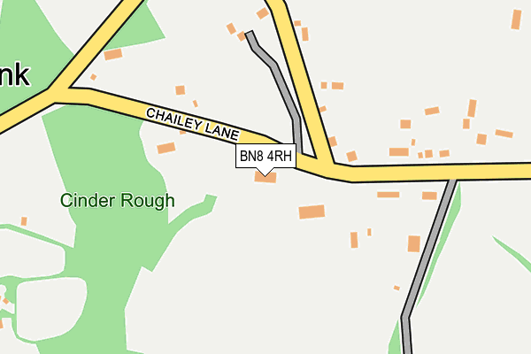
BN8 4RH lies on Cornwells Bank in North Chailey, Lewes. BN8 4RH is located in the Chailey, Barcombe & Hamsey electoral ward, within the local authority district of Lewes and the English Parliamentary constituency of Lewes. The Sub Integrated Care Board (ICB) Location is NHS Sussex ICB - 97R and the police force is Sussex. This postcode has been in use since January 1980.


GetTheData
Source: OS OpenMap – Local (Ordnance Survey)
Source: OS VectorMap District (Ordnance Survey)
Licence: Open Government Licence (requires attribution)
| Easting | 540903 |
| Northing | 120085 |
| Latitude | 50.962966 |
| Longitude | 0.005091 |
GetTheData
Source: Open Postcode Geo
Licence: Open Government Licence
| Street | Cornwells Bank |
| Locality | North Chailey |
| Town/City | Lewes |
| Country | England |
| Postcode District | BN8 |
| ➜ BN8 open data dashboard ➜ See where BN8 is on a map ➜ Where is Cornwell's Bank? | |
GetTheData
Source: Land Registry Price Paid Data
Licence: Open Government Licence
Elevation or altitude of BN8 4RH as distance above sea level:
| Metres | Feet | |
|---|---|---|
| Elevation | 50m | 164ft |
Elevation is measured from the approximate centre of the postcode, to the nearest point on an OS contour line from OS Terrain 50, which has contour spacing of ten vertical metres.
➜ How high above sea level am I? Find the elevation of your current position using your device's GPS.
GetTheData
Source: Open Postcode Elevation
Licence: Open Government Licence
| Ward | Chailey, Barcombe & Hamsey |
| Constituency | Lewes |
GetTheData
Source: ONS Postcode Database
Licence: Open Government Licence
| June 2022 | Burglary | On or near Chailey Lane | 65m |
| December 2021 | Other theft | On or near Chailey Lane | 65m |
| August 2021 | Vehicle crime | On or near Chailey Lane | 108m |
| ➜ Get more crime data in our Crime section | |||
GetTheData
Source: data.police.uk
Licence: Open Government Licence
| Allington Road (Station Road) | Newick | 905m |
| Allington Road (Station Road) | Newick | 925m |
| South Rough | Newick | 985m |
| Jackies Lane (Station Road) | North Chailey | 986m |
| Jackies Lane (Station Road) | North Chailey | 995m |
| Plumpton Station | 6km |
GetTheData
Source: NaPTAN
Licence: Open Government Licence
| Percentage of properties with Next Generation Access | 100.0% |
| Percentage of properties with Superfast Broadband | 0.0% |
| Percentage of properties with Ultrafast Broadband | 0.0% |
| Percentage of properties with Full Fibre Broadband | 0.0% |
Superfast Broadband is between 30Mbps and 300Mbps
Ultrafast Broadband is > 300Mbps
| Percentage of properties unable to receive 2Mbps | 0.0% |
| Percentage of properties unable to receive 5Mbps | 0.0% |
| Percentage of properties unable to receive 10Mbps | 0.0% |
| Percentage of properties unable to receive 30Mbps | 100.0% |
GetTheData
Source: Ofcom
Licence: Ofcom Terms of Use (requires attribution)
GetTheData
Source: ONS Postcode Database
Licence: Open Government Licence

➜ Get more ratings from the Food Standards Agency
GetTheData
Source: Food Standards Agency
Licence: FSA terms & conditions
| Last Collection | |||
|---|---|---|---|
| Location | Mon-Fri | Sat | Distance |
| Cornwells Bank | 15:00 | 07:45 | 83m |
| Newick Station | 16:30 | 09:30 | 1,171m |
| Fount Hill | 15:00 | 10:00 | 1,175m |
GetTheData
Source: Dracos
Licence: Creative Commons Attribution-ShareAlike
| Facility | Distance |
|---|---|
| King George V Playing Field (Newick) Allington Road, Newick Grass Pitches | 1.3km |
| Newick Lawn Tennis Club Blind Lane, Newick Outdoor Tennis Courts | 1.5km |
| Chailey Sports Ground Lewes Road, North Chailey, Lewes Grass Pitches | 2.2km |
GetTheData
Source: Active Places
Licence: Open Government Licence
| School | Phase of Education | Distance |
|---|---|---|
| Newick Church of England Primary School 63 Allington Road, Newick, Lewes, BN8 4NB | Primary | 972m |
| Chailey St Peter's Church of England Primary School Chailey St Peter's Ce Primary School, East Grinstead Road, North Chailey, Lewes, BN8 4DB | Primary | 1.8km |
| Chailey Heritage School Haywards Heath Road, North Chailey, Lewes, BN8 4EF | Not applicable | 2.7km |
GetTheData
Source: Edubase
Licence: Open Government Licence
The below table lists the International Territorial Level (ITL) codes (formerly Nomenclature of Territorial Units for Statistics (NUTS) codes) and Local Administrative Units (LAU) codes for BN8 4RH:
| ITL 1 Code | Name |
|---|---|
| TLJ | South East (England) |
| ITL 2 Code | Name |
| TLJ2 | Surrey, East and West Sussex |
| ITL 3 Code | Name |
| TLJ22 | East Sussex CC |
| LAU 1 Code | Name |
| E07000063 | Lewes |
GetTheData
Source: ONS Postcode Directory
Licence: Open Government Licence
The below table lists the Census Output Area (OA), Lower Layer Super Output Area (LSOA), and Middle Layer Super Output Area (MSOA) for BN8 4RH:
| Code | Name | |
|---|---|---|
| OA | E00106773 | |
| LSOA | E01021025 | Lewes 001C |
| MSOA | E02004379 | Lewes 001 |
GetTheData
Source: ONS Postcode Directory
Licence: Open Government Licence
| BN8 4RJ | Cornwells Bank | 161m |
| BN8 4RD | Cornwells Bank | 168m |
| BN8 4RL | Cornwells Bank | 276m |
| BN8 4RP | Cockfield Lane | 420m |
| BN8 4RB | Oxbottom | 461m |
| BN8 4RX | Cornwells Bank | 688m |
| BN8 4HR | Cinder Hill | 732m |
| BN8 4RA | 752m | |
| BN8 4NQ | Oxbottom Close | 854m |
| BN8 4HT | Lower Station Road | 855m |
GetTheData
Source: Open Postcode Geo; Land Registry Price Paid Data
Licence: Open Government Licence