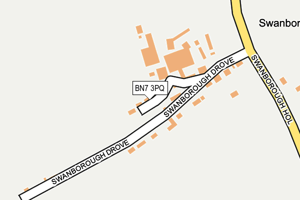
BN7 3PQ is in Swanborough, Lewes. BN7 3PQ is located in the Kingston electoral ward, within the local authority district of Lewes and the English Parliamentary constituency of Lewes. The Sub Integrated Care Board (ICB) Location is NHS Sussex ICB - 97R and the police force is Sussex. This postcode has been in use since January 1980.


GetTheData
Source: OS OpenMap – Local (Ordnance Survey)
Source: OS VectorMap District (Ordnance Survey)
Licence: Open Government Licence (requires attribution)
| Easting | 539986 |
| Northing | 107678 |
| Latitude | 50.851688 |
| Longitude | -0.012713 |
GetTheData
Source: Open Postcode Geo
Licence: Open Government Licence
| Locality | Swanborough |
| Town/City | Lewes |
| Country | England |
| Postcode District | BN7 |
| ➜ BN7 open data dashboard ➜ See where BN7 is on a map | |
GetTheData
Source: Land Registry Price Paid Data
Licence: Open Government Licence
Elevation or altitude of BN7 3PQ as distance above sea level:
| Metres | Feet | |
|---|---|---|
| Elevation | 40m | 131ft |
Elevation is measured from the approximate centre of the postcode, to the nearest point on an OS contour line from OS Terrain 50, which has contour spacing of ten vertical metres.
➜ How high above sea level am I? Find the elevation of your current position using your device's GPS.
GetTheData
Source: Open Postcode Elevation
Licence: Open Government Licence
| Ward | Kingston |
| Constituency | Lewes |
GetTheData
Source: ONS Postcode Database
Licence: Open Government Licence
| May 2022 | Vehicle crime | On or near Swanborough Hollow | 245m |
| March 2021 | Anti-social behaviour | On or near Swanborough Drove | 68m |
| ➜ Get more crime data in our Crime section | |||
GetTheData
Source: data.police.uk
Licence: Open Government Licence
| Swanborough Hollow | Swanborough Manor | 213m |
| Swanborough Hollow | Swanborough Manor | 234m |
| The Holdings (Wellgreen Lane) | Kingston | 657m |
| The Old Vicarage (Swanborough Hollow) | Iford | 677m |
| The Old Vicarage (Swanborough Hollow) | Iford | 693m |
| Lewes Station | 2.7km |
| Southease Station | 3.8km |
GetTheData
Source: NaPTAN
Licence: Open Government Licence
| Percentage of properties with Next Generation Access | 100.0% |
| Percentage of properties with Superfast Broadband | 100.0% |
| Percentage of properties with Ultrafast Broadband | 0.0% |
| Percentage of properties with Full Fibre Broadband | 0.0% |
Superfast Broadband is between 30Mbps and 300Mbps
Ultrafast Broadband is > 300Mbps
| Percentage of properties unable to receive 2Mbps | 0.0% |
| Percentage of properties unable to receive 5Mbps | 0.0% |
| Percentage of properties unable to receive 10Mbps | 0.0% |
| Percentage of properties unable to receive 30Mbps | 0.0% |
GetTheData
Source: Ofcom
Licence: Ofcom Terms of Use (requires attribution)
GetTheData
Source: ONS Postcode Database
Licence: Open Government Licence


➜ Get more ratings from the Food Standards Agency
GetTheData
Source: Food Standards Agency
Licence: FSA terms & conditions
| Last Collection | |||
|---|---|---|---|
| Location | Mon-Fri | Sat | Distance |
| Kingston Post Office | 16:45 | 09:15 | 886m |
| Kingston Ridge | 16:45 | 07:00 | 1,415m |
| Saint Annes Crescent | 17:30 | 11:30 | 2,391m |
GetTheData
Source: Dracos
Licence: Creative Commons Attribution-ShareAlike
| Facility | Distance |
|---|---|
| Owlswick School (Closed) Newhaven Road, Kingston, Lewes Health and Fitness Gym | 477m |
| Iford And Kingston Primary School Wellgreen Lane, Kingston, Lewes Grass Pitches | 788m |
| Kingston Community Pavilion Church Lane, Kingston, Lewes Outdoor Tennis Courts, Grass Pitches | 1.1km |
GetTheData
Source: Active Places
Licence: Open Government Licence
| School | Phase of Education | Distance |
|---|---|---|
| Owlswick School Newhaven Road, Lewes, Lewes, BN7 3NF | Not applicable | 671m |
| Iford and Kingston Church of England Primary School Wellgreen Lane, Kingston, Lewes, BN7 3NR | Primary | 793m |
| Northease Manor School Rodmell, Lewes, BN7 3EY | Not applicable | 1.7km |
GetTheData
Source: Edubase
Licence: Open Government Licence
The below table lists the International Territorial Level (ITL) codes (formerly Nomenclature of Territorial Units for Statistics (NUTS) codes) and Local Administrative Units (LAU) codes for BN7 3PQ:
| ITL 1 Code | Name |
|---|---|
| TLJ | South East (England) |
| ITL 2 Code | Name |
| TLJ2 | Surrey, East and West Sussex |
| ITL 3 Code | Name |
| TLJ22 | East Sussex CC |
| LAU 1 Code | Name |
| E07000063 | Lewes |
GetTheData
Source: ONS Postcode Directory
Licence: Open Government Licence
The below table lists the Census Output Area (OA), Lower Layer Super Output Area (LSOA), and Middle Layer Super Output Area (MSOA) for BN7 3PQ:
| Code | Name | |
|---|---|---|
| OA | E00106817 | |
| LSOA | E01021032 | Lewes 002C |
| MSOA | E02004380 | Lewes 002 |
GetTheData
Source: ONS Postcode Directory
Licence: Open Government Licence
| BN7 3PG | Manor Cottages | 59m |
| BN7 3PE | 106m | |
| BN7 3PJ | Newhaven Road | 298m |
| BN7 3PL | Newhaven Road | 506m |
| BN7 3NP | Wellgreen Lane | 624m |
| BN7 3NF | Newhaven Road | 646m |
| BN7 3NS | Wellgreen Lane | 663m |
| BN7 3NH | Wellgreen Lane | 673m |
| BN7 3NL | Snednore | 702m |
| BN7 3NE | Newhaven Road | 736m |
GetTheData
Source: Open Postcode Geo; Land Registry Price Paid Data
Licence: Open Government Licence