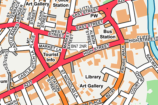
BN7 2NR is located in the Lewes Bridge electoral ward, within the local authority district of Lewes and the English Parliamentary constituency of Lewes. The Sub Integrated Care Board (ICB) Location is NHS Sussex ICB - 97R and the police force is Sussex. This postcode has been in use since January 1980.


GetTheData
Source: OS OpenMap – Local (Ordnance Survey)
Source: OS VectorMap District (Ordnance Survey)
Licence: Open Government Licence (requires attribution)
| Easting | 541665 |
| Northing | 110177 |
| Latitude | 50.873738 |
| Longitude | 0.012090 |
GetTheData
Source: Open Postcode Geo
Licence: Open Government Licence
| Country | England |
| Postcode District | BN7 |
| ➜ BN7 open data dashboard ➜ See where BN7 is on a map ➜ Where is Lewes? | |
GetTheData
Source: Land Registry Price Paid Data
Licence: Open Government Licence
Elevation or altitude of BN7 2NR as distance above sea level:
| Metres | Feet | |
|---|---|---|
| Elevation | 20m | 66ft |
Elevation is measured from the approximate centre of the postcode, to the nearest point on an OS contour line from OS Terrain 50, which has contour spacing of ten vertical metres.
➜ How high above sea level am I? Find the elevation of your current position using your device's GPS.
GetTheData
Source: Open Postcode Elevation
Licence: Open Government Licence
| Ward | Lewes Bridge |
| Constituency | Lewes |
GetTheData
Source: ONS Postcode Database
Licence: Open Government Licence
| January 2024 | Burglary | On or near White Hill | 287m |
| December 2023 | Other crime | On or near Castle Ditch Lane | 204m |
| December 2023 | Criminal damage and arson | On or near Castle Ditch Lane | 204m |
| ➜ Get more crime data in our Crime section | |||
GetTheData
Source: data.police.uk
Licence: Open Government Licence
| Market Street (High Street) | Lewes | 40m |
| West Street | Lewes | 125m |
| Fisher Street | Lewes | 156m |
| Friars' Walk (Friar's Walk) | Lewes | 174m |
| Law Courts (High Street) | Lewes | 178m |
| Lewes Station | 0.3km |
| Cooksbridge Station | 3.7km |
| Glynde Station | 4.4km |
GetTheData
Source: NaPTAN
Licence: Open Government Licence
GetTheData
Source: ONS Postcode Database
Licence: Open Government Licence


➜ Get more ratings from the Food Standards Agency
GetTheData
Source: Food Standards Agency
Licence: FSA terms & conditions
| Last Collection | |||
|---|---|---|---|
| Location | Mon-Fri | Sat | Distance |
| Abinger Place | 17:30 | 11:30 | 302m |
| Paddock Road | 17:30 | 11:30 | 319m |
| Lewes Station Outer | 17:30 | 11:30 | 386m |
GetTheData
Source: Dracos
Licence: Creative Commons Attribution-ShareAlike
| Facility | Distance |
|---|---|
| Harts Leisure Club High Street, Lewes Swimming Pool, Health and Fitness Gym, Studio | 176m |
| Ymca (Lewes) (Closed) Westgate Street, Lewes Sports Hall | 447m |
| The Pells Outdoor Swimming Pool Brook Street, Lewes Swimming Pool | 485m |
GetTheData
Source: Active Places
Licence: Open Government Licence
| School | Phase of Education | Distance |
|---|---|---|
| Lewes Old Grammar School 140 High Street, Lewes, East Sussex, BN7 1XS | Not applicable | 542m |
| Priory School Mountfield Road, Lewes, BN7 2XN | Secondary | 596m |
| Southover CofE Primary School Potters Lane, Lewes, BN7 1JP | Primary | 699m |
GetTheData
Source: Edubase
Licence: Open Government Licence
The below table lists the International Territorial Level (ITL) codes (formerly Nomenclature of Territorial Units for Statistics (NUTS) codes) and Local Administrative Units (LAU) codes for BN7 2NR:
| ITL 1 Code | Name |
|---|---|
| TLJ | South East (England) |
| ITL 2 Code | Name |
| TLJ2 | Surrey, East and West Sussex |
| ITL 3 Code | Name |
| TLJ22 | East Sussex CC |
| LAU 1 Code | Name |
| E07000063 | Lewes |
GetTheData
Source: ONS Postcode Directory
Licence: Open Government Licence
The below table lists the Census Output Area (OA), Lower Layer Super Output Area (LSOA), and Middle Layer Super Output Area (MSOA) for BN7 2NR:
| Code | Name | |
|---|---|---|
| OA | E00106836 | |
| LSOA | E01021035 | Lewes 003C |
| MSOA | E02004381 | Lewes 003 |
GetTheData
Source: ONS Postcode Directory
Licence: Open Government Licence
| BN7 2NS | High Street | 16m |
| BN7 2LU | High Street | 30m |
| BN7 2NB | Market Street | 51m |
| BN7 2LT | Broomans Lane | 57m |
| BN7 2BH | Broomans Terrace | 68m |
| BN7 2GG | Walwers Lane | 72m |
| BN7 2ND | Albion Street | 73m |
| BN7 2LN | High Street | 97m |
| BN7 2PA | North Street | 103m |
| BN7 2NT | Market Lane | 108m |
GetTheData
Source: Open Postcode Geo; Land Registry Price Paid Data
Licence: Open Government Licence