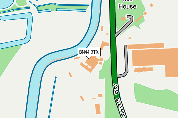
BN44 3TX is located in the Bramber, Upper Beeding & Woodmancote electoral ward, within the local authority district of Horsham and the English Parliamentary constituency of Arundel and South Downs. The Sub Integrated Care Board (ICB) Location is NHS Sussex ICB - 70F and the police force is Sussex. This postcode has been in use since May 2006.


GetTheData
Source: OS OpenMap – Local (Ordnance Survey)
Source: OS VectorMap District (Ordnance Survey)
Licence: Open Government Licence (requires attribution)
| Easting | 519829 |
| Northing | 108589 |
| Latitude | 50.864393 |
| Longitude | -0.298595 |
GetTheData
Source: Open Postcode Geo
Licence: Open Government Licence
| Country | England |
| Postcode District | BN44 |
| ➜ BN44 open data dashboard ➜ See where BN44 is on a map | |
GetTheData
Source: Land Registry Price Paid Data
Licence: Open Government Licence
Elevation or altitude of BN44 3TX as distance above sea level:
| Metres | Feet | |
|---|---|---|
| Elevation | 10m | 33ft |
Elevation is measured from the approximate centre of the postcode, to the nearest point on an OS contour line from OS Terrain 50, which has contour spacing of ten vertical metres.
➜ How high above sea level am I? Find the elevation of your current position using your device's GPS.
GetTheData
Source: Open Postcode Elevation
Licence: Open Government Licence
| Ward | Bramber, Upper Beeding & Woodmancote |
| Constituency | Arundel And South Downs |
GetTheData
Source: ONS Postcode Database
Licence: Open Government Licence
| April 2022 | Violence and sexual offences | On or near Dacre Gardens | 435m |
| March 2022 | Violence and sexual offences | On or near Dacre Gardens | 435m |
| January 2022 | Criminal damage and arson | On or near Dacre Gardens | 435m |
| ➜ Get more crime data in our Crime section | |||
GetTheData
Source: data.police.uk
Licence: Open Government Licence
| Old Cement Works (Steyning Road) | Upper Beeding | 62m |
| Old Cement Works (Steyning Road) | Upper Beeding | 72m |
| Dacre Gardens (Steyning Road) | Upper Beeding | 462m |
| Dacre Gardens (Shoreham Road) | Upper Beeding | 519m |
| Erringham Farm (Steyning Road A283) | Shoreham-by-sea | 586m |
| Shoreham-by-Sea (Sussex) Station | 3.8km |
| Lancing Station | 4.5km |
| Southwick Station | 5.7km |
GetTheData
Source: NaPTAN
Licence: Open Government Licence
GetTheData
Source: ONS Postcode Database
Licence: Open Government Licence


➜ Get more ratings from the Food Standards Agency
GetTheData
Source: Food Standards Agency
Licence: FSA terms & conditions
| Last Collection | |||
|---|---|---|---|
| Location | Mon-Fri | Sat | Distance |
| Coombes | 15:45 | 11:45 | 745m |
| Bramber | 17:30 | 11:45 | 2,272m |
| Mill Hill | 18:00 | 11:45 | 2,515m |
GetTheData
Source: Dracos
Licence: Creative Commons Attribution-ShareAlike
| Facility | Distance |
|---|---|
| Steyning Grammar School (The Towers) Henfield Road, Upper Beeding, Steyning Swimming Pool, Sports Hall, Grass Pitches, Outdoor Tennis Courts | 1.7km |
| Upper Beeding Recreation Ground High Street, Upper Beeding, Steyning Grass Pitches, Outdoor Tennis Courts, Sports Hall | 2km |
| Upper Beeding Primary School School Road, Upper Beeding, Steyning Grass Pitches | 2.1km |
GetTheData
Source: Active Places
Licence: Open Government Licence
| School | Phase of Education | Distance |
|---|---|---|
| Lancing College Lancing, BN15 0RW | Not applicable | 2.1km |
| Upper Beeding Primary School School Road, Upper Beeding, Steyning, BN44 3HY | Primary | 2.3km |
| North Lancing Primary School Mill Road, Adur, Lancing, BN15 0PT | Primary | 3.2km |
GetTheData
Source: Edubase
Licence: Open Government Licence
The below table lists the International Territorial Level (ITL) codes (formerly Nomenclature of Territorial Units for Statistics (NUTS) codes) and Local Administrative Units (LAU) codes for BN44 3TX:
| ITL 1 Code | Name |
|---|---|
| TLJ | South East (England) |
| ITL 2 Code | Name |
| TLJ2 | Surrey, East and West Sussex |
| ITL 3 Code | Name |
| TLJ28 | West Sussex (North East) |
| LAU 1 Code | Name |
| E07000227 | Horsham |
GetTheData
Source: ONS Postcode Directory
Licence: Open Government Licence
The below table lists the Census Output Area (OA), Lower Layer Super Output Area (LSOA), and Middle Layer Super Output Area (MSOA) for BN44 3TX:
| Code | Name | |
|---|---|---|
| OA | E00161241 | |
| LSOA | E01031617 | Horsham 016B |
| MSOA | E02006603 | Horsham 016 |
GetTheData
Source: ONS Postcode Directory
Licence: Open Government Licence
| BN44 3TE | Dacre Villas | 300m |
| BN44 3TD | Dacre Gardens | 443m |
| BN44 3TU | Shoreham Road | 630m |
| BN44 3WS | Botolphs Road | 764m |
| BN15 0RR | Coombes Road | 938m |
| BN43 5FD | Steyning Road | 1197m |
| BN44 3WB | Botolphs Road | 1213m |
| BN44 3WT | Botolphs Road | 1391m |
| BN15 0RP | 1432m | |
| BN44 3TN | Shoreham Road | 1485m |
GetTheData
Source: Open Postcode Geo; Land Registry Price Paid Data
Licence: Open Government Licence