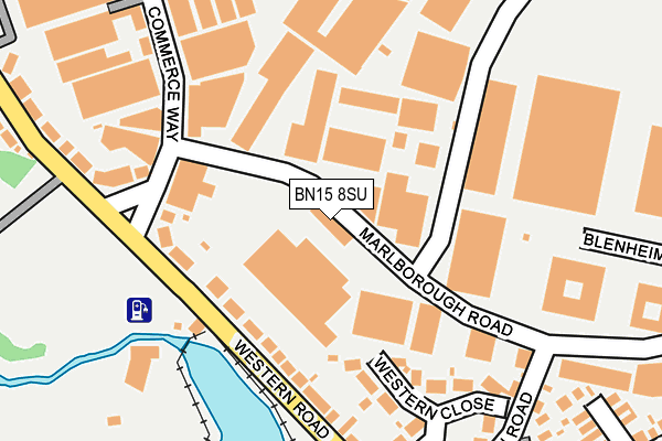
BN15 8SU is located in the Churchill electoral ward, within the local authority district of Adur and the English Parliamentary constituency of East Worthing and Shoreham. The Sub Integrated Care Board (ICB) Location is NHS Sussex ICB - 70F and the police force is Sussex. This postcode has been in use since July 1983.


GetTheData
Source: OS OpenMap – Local (Ordnance Survey)
Source: OS VectorMap District (Ordnance Survey)
Licence: Open Government Licence (requires attribution)
| Easting | 517326 |
| Northing | 103702 |
| Latitude | 50.820978 |
| Longitude | -0.335710 |
GetTheData
Source: Open Postcode Geo
Licence: Open Government Licence
| Country | England |
| Postcode District | BN15 |
| ➜ BN15 open data dashboard ➜ See where BN15 is on a map ➜ Where is Lancing? | |
GetTheData
Source: Land Registry Price Paid Data
Licence: Open Government Licence
Elevation or altitude of BN15 8SU as distance above sea level:
| Metres | Feet | |
|---|---|---|
| Elevation | 10m | 33ft |
Elevation is measured from the approximate centre of the postcode, to the nearest point on an OS contour line from OS Terrain 50, which has contour spacing of ten vertical metres.
➜ How high above sea level am I? Find the elevation of your current position using your device's GPS.
GetTheData
Source: Open Postcode Elevation
Licence: Open Government Licence
| Ward | Churchill |
| Constituency | East Worthing And Shoreham |
GetTheData
Source: ONS Postcode Database
Licence: Open Government Licence
| June 2022 | Other theft | On or near Western Road | 110m |
| June 2022 | Public order | On or near Marlborough Road | 201m |
| June 2022 | Violence and sexual offences | On or near St Mark'S Crescent | 440m |
| ➜ Get more crime data in our Crime section | |||
GetTheData
Source: data.police.uk
Licence: Open Government Licence
| Brooklands (Western Road) | Lancing | 91m |
| Business Park (Western Road) | Lancing | 103m |
| Water Treatment Works (Western Road) | Lancing | 263m |
| Winston Road (Western Road) | Lancing | 291m |
| Winston Road (Western Road) | Lancing | 292m |
| Lancing Station | 1.1km |
| East Worthing Station | 1.4km |
| Worthing Station | 2.9km |
GetTheData
Source: NaPTAN
Licence: Open Government Licence
GetTheData
Source: ONS Postcode Database
Licence: Open Government Licence


➜ Get more ratings from the Food Standards Agency
GetTheData
Source: Food Standards Agency
Licence: FSA terms & conditions
| Last Collection | |||
|---|---|---|---|
| Location | Mon-Fri | Sat | Distance |
| Bowness Avenue Post Office | 17:15 | 12:00 | 707m |
| Cokeham Lane | 17:15 | 10:30 | 967m |
| Station Parade | 18:00 | 11:45 | 1,140m |
GetTheData
Source: Dracos
Licence: Creative Commons Attribution-ShareAlike
| Facility | Distance |
|---|---|
| Brooklands Golf Club (Closed) Brighton Road, Worthing Golf | 476m |
| South Coast Gym Chartwell Road, Lancing Business Park, Lancing Health and Fitness Gym | 494m |
| Croshaw Recreation Ground Grafton Drive, Sompting, Lancing Grass Pitches | 801m |
GetTheData
Source: Active Places
Licence: Open Government Licence
| School | Phase of Education | Distance |
|---|---|---|
| Springboard Education 55 South Street, Lancing, West Sussex, Lancing, BN15 8AN | Not applicable | 1km |
| Boundstone Nursery School Upper Boundstone Lane, Boundstone Nursery School, Lancing, BN15 9QX | Nursery | 1.4km |
| Sompting Village Primary School White Styles Road, Sompting, Lancing, BN15 0BU | Primary | 1.4km |
GetTheData
Source: Edubase
Licence: Open Government Licence
The below table lists the International Territorial Level (ITL) codes (formerly Nomenclature of Territorial Units for Statistics (NUTS) codes) and Local Administrative Units (LAU) codes for BN15 8SU:
| ITL 1 Code | Name |
|---|---|
| TLJ | South East (England) |
| ITL 2 Code | Name |
| TLJ2 | Surrey, East and West Sussex |
| ITL 3 Code | Name |
| TLJ27 | West Sussex (South West) |
| LAU 1 Code | Name |
| E07000223 | Adur |
GetTheData
Source: ONS Postcode Directory
Licence: Open Government Licence
The below table lists the Census Output Area (OA), Lower Layer Super Output Area (LSOA), and Middle Layer Super Output Area (MSOA) for BN15 8SU:
| Code | Name | |
|---|---|---|
| OA | E00159803 | |
| LSOA | E01031342 | Adur 008B |
| MSOA | E02006541 | Adur 008 |
GetTheData
Source: ONS Postcode Directory
Licence: Open Government Licence
| BN15 8RX | Western Road | 78m |
| BN15 8UP | Commerce Way | 133m |
| BN15 8SP | Chartwell Road | 170m |
| BN15 8RU | Western Close | 173m |
| BN15 8RY | The Triangle | 180m |
| BN15 8TA | Commerce Way | 239m |
| BN15 8SL | Winston Road | 262m |
| BN15 8RZ | Western Road | 264m |
| BN15 8RT | Western Road | 272m |
| BN15 8TU | Chartwell Road | 289m |
GetTheData
Source: Open Postcode Geo; Land Registry Price Paid Data
Licence: Open Government Licence