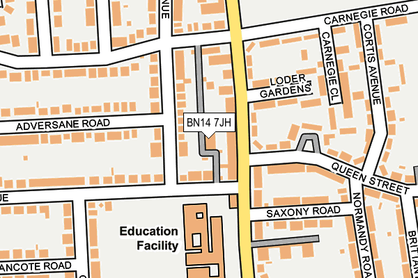
BN14 7JH lies on St Lawrence Lane in Worthing. BN14 7JH is located in the Gaisford electoral ward, within the local authority district of Worthing and the English Parliamentary constituency of East Worthing and Shoreham. The Sub Integrated Care Board (ICB) Location is NHS Sussex ICB - 70F and the police force is Sussex. This postcode has been in use since January 1980.


GetTheData
Source: OS OpenMap – Local (Ordnance Survey)
Source: OS VectorMap District (Ordnance Survey)
Licence: Open Government Licence (requires attribution)
| Easting | 514171 |
| Northing | 104030 |
| Latitude | 50.824563 |
| Longitude | -0.380405 |
GetTheData
Source: Open Postcode Geo
Licence: Open Government Licence
| Street | St Lawrence Lane |
| Town/City | Worthing |
| Country | England |
| Postcode District | BN14 |
| ➜ BN14 open data dashboard ➜ See where BN14 is on a map ➜ Where is Worthing? | |
GetTheData
Source: Land Registry Price Paid Data
Licence: Open Government Licence
Elevation or altitude of BN14 7JH as distance above sea level:
| Metres | Feet | |
|---|---|---|
| Elevation | 10m | 33ft |
Elevation is measured from the approximate centre of the postcode, to the nearest point on an OS contour line from OS Terrain 50, which has contour spacing of ten vertical metres.
➜ How high above sea level am I? Find the elevation of your current position using your device's GPS.
GetTheData
Source: Open Postcode Elevation
Licence: Open Government Licence
| Ward | Gaisford |
| Constituency | East Worthing And Shoreham |
GetTheData
Source: ONS Postcode Database
Licence: Open Government Licence
| June 2022 | Drugs | On or near South Farm Road | 86m |
| June 2022 | Violence and sexual offences | On or near South Farm Road | 86m |
| June 2022 | Violence and sexual offences | On or near South Farm Road | 86m |
| ➜ Get more crime data in our Crime section | |||
GetTheData
Source: data.police.uk
Licence: Open Government Licence
| Queen Street (South Farm Road) | Broadwater | 41m |
| Balcombe Avenue (St Lawrence Avenue) | Tarring | 133m |
| South Farm Road (Wiston Avenue) | Broadwater | 142m |
| Cranleigh Road (Wiston Avenue) | Tarring | 167m |
| Worthing High School (South Farm Road) | Worthing | 171m |
| Worthing Station | 0.7km |
| West Worthing Station | 1.1km |
| East Worthing Station | 1.8km |
GetTheData
Source: NaPTAN
Licence: Open Government Licence
GetTheData
Source: ONS Postcode Database
Licence: Open Government Licence


➜ Get more ratings from the Food Standards Agency
GetTheData
Source: Food Standards Agency
Licence: FSA terms & conditions
| Last Collection | |||
|---|---|---|---|
| Location | Mon-Fri | Sat | Distance |
| South Farm Road Post Office | 17:15 | 12:15 | 38m |
| Loxwood Avenue | 17:30 | 12:30 | 402m |
| Broomfield Avenue | 17:30 | 12:30 | 509m |
GetTheData
Source: Dracos
Licence: Creative Commons Attribution-ShareAlike
| Facility | Distance |
|---|---|
| Worthing High School South Farm Road, Worthing Health and Fitness Gym, Artificial Grass Pitch, Grass Pitches, Sports Hall, Outdoor Tennis Courts | 144m |
| Northbrook Fitness Centre (Nuffield Health) (Closed) Broadwater Road, Worthing Health and Fitness Gym, Studio | 351m |
| Broadwater Primary School Rectory Gardens, Worthing Grass Pitches | 492m |
GetTheData
Source: Active Places
Licence: Open Government Licence
| School | Phase of Education | Distance |
|---|---|---|
| Worthing High School South Farm Road, Worthing, BN14 7AR | Secondary | 144m |
| Bohunt School Worthing 65a Broadwater Road, Worthing, BN14 8AH | Secondary | 452m |
| Broadwater CofE Primary School Rectory Gardens, Worthing, BN14 7TQ | Primary | 493m |
GetTheData
Source: Edubase
Licence: Open Government Licence
The below table lists the International Territorial Level (ITL) codes (formerly Nomenclature of Territorial Units for Statistics (NUTS) codes) and Local Administrative Units (LAU) codes for BN14 7JH:
| ITL 1 Code | Name |
|---|---|
| TLJ | South East (England) |
| ITL 2 Code | Name |
| TLJ2 | Surrey, East and West Sussex |
| ITL 3 Code | Name |
| TLJ27 | West Sussex (South West) |
| LAU 1 Code | Name |
| E07000229 | Worthing |
GetTheData
Source: ONS Postcode Directory
Licence: Open Government Licence
The below table lists the Census Output Area (OA), Lower Layer Super Output Area (LSOA), and Middle Layer Super Output Area (MSOA) for BN14 7JH:
| Code | Name | |
|---|---|---|
| OA | E00162155 | |
| LSOA | E01031799 | Worthing 008C |
| MSOA | E02006628 | Worthing 008 |
GetTheData
Source: ONS Postcode Directory
Licence: Open Government Licence
| BN14 7AX | South Farm Road | 35m |
| BN14 7JE | St Lawrence Avenue | 57m |
| BN14 7BA | South Farm Road | 74m |
| BN14 7RU | Balcombe Avenue | 75m |
| BN14 7AU | South Farm Road | 98m |
| BN14 7BB | South Farm Road | 100m |
| BN14 7AY | South Farm Road | 106m |
| BN14 7AZ | Loder Gardens | 134m |
| BN14 7JF | St Lawrence Avenue | 138m |
| BN14 7BE | Queen Street | 152m |
GetTheData
Source: Open Postcode Geo; Land Registry Price Paid Data
Licence: Open Government Licence