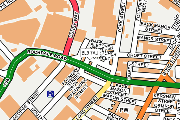
BL9 7AU is located in the Bury East electoral ward, within the metropolitan district of Bury and the English Parliamentary constituency of Bury North. The Sub Integrated Care Board (ICB) Location is NHS Greater Manchester ICB - 00V and the police force is Greater Manchester. This postcode has been in use since January 1980.


GetTheData
Source: OS OpenMap – Local (Ordnance Survey)
Source: OS VectorMap District (Ordnance Survey)
Licence: Open Government Licence (requires attribution)
| Easting | 381024 |
| Northing | 410822 |
| Latitude | 53.593626 |
| Longitude | -2.288171 |
GetTheData
Source: Open Postcode Geo
Licence: Open Government Licence
| Country | England |
| Postcode District | BL9 |
| ➜ BL9 open data dashboard ➜ See where BL9 is on a map ➜ Where is Bury? | |
GetTheData
Source: Land Registry Price Paid Data
Licence: Open Government Licence
Elevation or altitude of BL9 7AU as distance above sea level:
| Metres | Feet | |
|---|---|---|
| Elevation | 100m | 328ft |
Elevation is measured from the approximate centre of the postcode, to the nearest point on an OS contour line from OS Terrain 50, which has contour spacing of ten vertical metres.
➜ How high above sea level am I? Find the elevation of your current position using your device's GPS.
GetTheData
Source: Open Postcode Elevation
Licence: Open Government Licence
| Ward | Bury East |
| Constituency | Bury North |
GetTheData
Source: ONS Postcode Database
Licence: Open Government Licence
| November 2021 | Other theft | On or near Back Ingham Street | 446m |
| August 2021 | Violence and sexual offences | On or near Parking Area | 256m |
| August 2021 | Violence and sexual offences | On or near Back Heywood Street East | 299m |
| ➜ Get more crime data in our Crime section | |||
GetTheData
Source: data.police.uk
Licence: Open Government Licence
| First Bus Depot (Rochdale Rd) | Bury | 34m |
| Rochdale Rd/Robin Hood (Rochdale Rd) | Bury | 42m |
| Rochdale Rd/Iceland (Rochdale Rd) | Bury | 161m |
| Rochdale Rd/Iceland (Rochdale Rd) | Bury | 211m |
| Heywood St/Rochdale Rd (Heywood St) | Bury | 229m |
| Bury (Manchester Metrolink) (The Haymarket) | Bury | 662m |
| Bury Bolton Street (East Lancashire Railway) | Bury | 764m |
GetTheData
Source: NaPTAN
Licence: Open Government Licence
| Percentage of properties with Next Generation Access | 100.0% |
| Percentage of properties with Superfast Broadband | 100.0% |
| Percentage of properties with Ultrafast Broadband | 100.0% |
| Percentage of properties with Full Fibre Broadband | 0.0% |
Superfast Broadband is between 30Mbps and 300Mbps
Ultrafast Broadband is > 300Mbps
| Percentage of properties unable to receive 2Mbps | 0.0% |
| Percentage of properties unable to receive 5Mbps | 0.0% |
| Percentage of properties unable to receive 10Mbps | 0.0% |
| Percentage of properties unable to receive 30Mbps | 0.0% |
GetTheData
Source: Ofcom
Licence: Ofcom Terms of Use (requires attribution)
GetTheData
Source: ONS Postcode Database
Licence: Open Government Licence

➜ Get more ratings from the Food Standards Agency
GetTheData
Source: Food Standards Agency
Licence: FSA terms & conditions
| Last Collection | |||
|---|---|---|---|
| Location | Mon-Fri | Sat | Distance |
| Hornby Buildings | 18:30 | 11:00 | 408m |
| Houghton Street | 17:40 | 11:10 | 736m |
| Bolton Street Station | 18:40 | 11:20 | 793m |
GetTheData
Source: Dracos
Licence: Creative Commons Attribution-ShareAlike
| Facility | Distance |
|---|---|
| Derbys Fitness Centre (Closed) Derby Street, Bury Health and Fitness Gym | 137m |
| Jd Gyms (Bury) George Street, Bury Health and Fitness Gym | 141m |
| Puregym (Bury) The Rock, Rochdale Road, Bury Health and Fitness Gym | 182m |
GetTheData
Source: Active Places
Licence: Open Government Licence
| School | Phase of Education | Distance |
|---|---|---|
| St Thomas Church of England Primary School Pimhole Road, Bury, BL9 7EY | Primary | 496m |
| St Marie's Roman Catholic Primary School, Bury Edward Street, The Mosses, Bury, BL9 0RZ | Primary | 520m |
| Holy Trinity Primary School Cecil Street, Bury, BL9 0SB | Primary | 564m |
GetTheData
Source: Edubase
Licence: Open Government Licence
The below table lists the International Territorial Level (ITL) codes (formerly Nomenclature of Territorial Units for Statistics (NUTS) codes) and Local Administrative Units (LAU) codes for BL9 7AU:
| ITL 1 Code | Name |
|---|---|
| TLD | North West (England) |
| ITL 2 Code | Name |
| TLD3 | Greater Manchester |
| ITL 3 Code | Name |
| TLD37 | Greater Manchester North East |
| LAU 1 Code | Name |
| E08000002 | Bury |
GetTheData
Source: ONS Postcode Directory
Licence: Open Government Licence
The below table lists the Census Output Area (OA), Lower Layer Super Output Area (LSOA), and Middle Layer Super Output Area (MSOA) for BL9 7AU:
| Code | Name | |
|---|---|---|
| OA | E00025425 | |
| LSOA | E01005024 | Bury 008E |
| MSOA | E02001026 | Bury 008 |
GetTheData
Source: ONS Postcode Directory
Licence: Open Government Licence
| BL9 7AT | Fletcher Street | 54m |
| BL9 7AY | Rochdale Road | 133m |
| BL9 7BA | Rochdale Road | 162m |
| BL9 0JQ | South Street | 188m |
| BL9 7BG | Croft Street | 215m |
| BL9 7DY | Heywood Street | 269m |
| BL9 0QY | St Johns Gardens | 277m |
| BL9 0NP | St Johns Gardens | 295m |
| BL9 7HH | Kershaw Street | 307m |
| BL9 7BD | Rochdale Road | 309m |
GetTheData
Source: Open Postcode Geo; Land Registry Price Paid Data
Licence: Open Government Licence