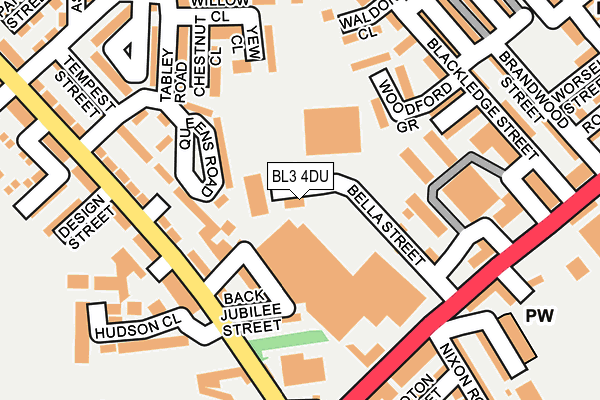
BL3 4DU is located in the Rumworth electoral ward, within the metropolitan district of Bolton and the English Parliamentary constituency of Bolton South East. The Sub Integrated Care Board (ICB) Location is NHS Greater Manchester ICB - 00T and the police force is Greater Manchester. This postcode has been in use since January 1980.


GetTheData
Source: OS OpenMap – Local (Ordnance Survey)
Source: OS VectorMap District (Ordnance Survey)
Licence: Open Government Licence (requires attribution)
| Easting | 370019 |
| Northing | 407569 |
| Latitude | 53.563872 |
| Longitude | -2.454121 |
GetTheData
Source: Open Postcode Geo
Licence: Open Government Licence
| Country | England |
| Postcode District | BL3 |
| ➜ BL3 open data dashboard ➜ See where BL3 is on a map ➜ Where is Bolton? | |
GetTheData
Source: Land Registry Price Paid Data
Licence: Open Government Licence
Elevation or altitude of BL3 4DU as distance above sea level:
| Metres | Feet | |
|---|---|---|
| Elevation | 140m | 459ft |
Elevation is measured from the approximate centre of the postcode, to the nearest point on an OS contour line from OS Terrain 50, which has contour spacing of ten vertical metres.
➜ How high above sea level am I? Find the elevation of your current position using your device's GPS.
GetTheData
Source: Open Postcode Elevation
Licence: Open Government Licence
| Ward | Rumworth |
| Constituency | Bolton South East |
GetTheData
Source: ONS Postcode Database
Licence: Open Government Licence
| August 2021 | Violence and sexual offences | On or near Back Rosamond Street | 369m |
| ➜ Get more crime data in our Crime section | |||
GetTheData
Source: data.police.uk
Licence: Open Government Licence
| Deane Church Lane/Hudson Road (Deane Church La) | Daubhill | 154m |
| Deane Church Lane/St. Helens Road (Deane Church La) | Daubhill | 164m |
| St Helens Road/Nixon Road (St Helens Road) | Daubhill | 186m |
| St Helens Road/Deane Church Lane (St Helens Road) | Daubhill | 199m |
| St Helens Road/Nixon Road (St Helens Road) | Daubhill | 201m |
| Bolton Station | 2.2km |
| Lostock Station | 2.8km |
| Moses Gate Station | 3.6km |
GetTheData
Source: NaPTAN
Licence: Open Government Licence
GetTheData
Source: ONS Postcode Database
Licence: Open Government Licence


➜ Get more ratings from the Food Standards Agency
GetTheData
Source: Food Standards Agency
Licence: FSA terms & conditions
| Last Collection | |||
|---|---|---|---|
| Location | Mon-Fri | Sat | Distance |
| Lever Street Little Lever | 17:30 | 11:05 | 781m |
| Higher Swan Lane | 17:30 | 11:30 | 809m |
| Blackshaw Lane | 16:45 | 11:25 | 838m |
GetTheData
Source: Dracos
Licence: Creative Commons Attribution-ShareAlike
| Facility | Distance |
|---|---|
| Brandwood Primary School Brandwood Street, Bolton Grass Pitches | 297m |
| Busybodies Ladies Only Gym Morris Green Lane, Bolton Health and Fitness Gym | 306m |
| Hulton Lane Playing Fields Edge Hill Road, Bolton Grass Pitches | 501m |
GetTheData
Source: Active Places
Licence: Open Government Licence
| School | Phase of Education | Distance |
|---|---|---|
| Brandwood Primary School Brandwood Street, Bolton, BL3 4BG | Primary | 267m |
| Al Jamiah Al Islamiyyah Willows Lane, Bolton, BL3 4HE | Not applicable | 447m |
| The Olive Tree Primary School Bolton Adelaide Street, Daubhill, Bolton, BL3 3NY | Primary | 475m |
GetTheData
Source: Edubase
Licence: Open Government Licence
The below table lists the International Territorial Level (ITL) codes (formerly Nomenclature of Territorial Units for Statistics (NUTS) codes) and Local Administrative Units (LAU) codes for BL3 4DU:
| ITL 1 Code | Name |
|---|---|
| TLD | North West (England) |
| ITL 2 Code | Name |
| TLD3 | Greater Manchester |
| ITL 3 Code | Name |
| TLD36 | Greater Manchester North West |
| LAU 1 Code | Name |
| E08000001 | Bolton |
GetTheData
Source: ONS Postcode Directory
Licence: Open Government Licence
The below table lists the Census Output Area (OA), Lower Layer Super Output Area (LSOA), and Middle Layer Super Output Area (MSOA) for BL3 4DU:
| Code | Name | |
|---|---|---|
| OA | E00024458 | |
| LSOA | E01004828 | Bolton 023A |
| MSOA | E02001006 | Bolton 023 |
GetTheData
Source: ONS Postcode Directory
Licence: Open Government Licence
| BL3 4EF | Minnie Street | 99m |
| BL3 4EE | Jubilee Street | 122m |
| BL3 4EG | Deane Church Lane | 131m |
| BL3 4ER | Queens Road | 148m |
| BL3 4DP | Yew Close | 153m |
| BL3 4HU | Milton Avenue | 154m |
| BL3 4DR | Chestnut Close | 155m |
| BL3 4DJ | Woodford Grove | 155m |
| BL3 4DL | Oakford Walk | 164m |
| BL3 4EQ | Deane Church Lane | 166m |
GetTheData
Source: Open Postcode Geo; Land Registry Price Paid Data
Licence: Open Government Licence