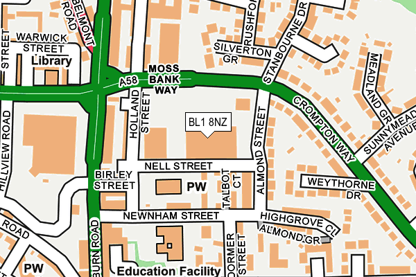
BL1 8NZ is located in the Astley Bridge electoral ward, within the metropolitan district of Bolton and the English Parliamentary constituency of Bolton North East. The Sub Integrated Care Board (ICB) Location is NHS Greater Manchester ICB - 00T and the police force is Greater Manchester. This postcode has been in use since January 1980.


GetTheData
Source: OS OpenMap – Local (Ordnance Survey)
Source: OS VectorMap District (Ordnance Survey)
Licence: Open Government Licence (requires attribution)
| Easting | 371615 |
| Northing | 411611 |
| Latitude | 53.600290 |
| Longitude | -2.430394 |
GetTheData
Source: Open Postcode Geo
Licence: Open Government Licence
| Country | England |
| Postcode District | BL1 |
| ➜ BL1 open data dashboard ➜ See where BL1 is on a map ➜ Where is Bolton? | |
GetTheData
Source: Land Registry Price Paid Data
Licence: Open Government Licence
Elevation or altitude of BL1 8NZ as distance above sea level:
| Metres | Feet | |
|---|---|---|
| Elevation | 120m | 394ft |
Elevation is measured from the approximate centre of the postcode, to the nearest point on an OS contour line from OS Terrain 50, which has contour spacing of ten vertical metres.
➜ How high above sea level am I? Find the elevation of your current position using your device's GPS.
GetTheData
Source: Open Postcode Elevation
Licence: Open Government Licence
| Ward | Astley Bridge |
| Constituency | Bolton North East |
GetTheData
Source: ONS Postcode Database
Licence: Open Government Licence
| Crompton Way/The Pineapple (Crompton Way) | Astley Bridge | 76m |
| Crompton Way/The Pineapple (Crompton Way) | Astley Bridge | 107m |
| Crompton Way/Sunnymead Avenue (Crompton Way) | Astley Bridge | 171m |
| Blackburn Rd/Asda (Blackburn Road) | Astley Bridge | 178m |
| Blackburn Rd/Asda (Blackburn Road) | Astley Bridge | 183m |
| Hall i' th' Wood Station | 1.2km |
| Bromley Cross Station | 2km |
| Bolton Station | 2.9km |
GetTheData
Source: NaPTAN
Licence: Open Government Licence
GetTheData
Source: ONS Postcode Database
Licence: Open Government Licence


➜ Get more ratings from the Food Standards Agency
GetTheData
Source: Food Standards Agency
Licence: FSA terms & conditions
| Last Collection | |||
|---|---|---|---|
| Location | Mon-Fri | Sat | Distance |
| Broad'oth Lane | 17:00 | 11:00 | 591m |
| Higher Blackburn Road P O | 17:10 | 12:00 | 605m |
| Sharples Avenue P O | 17:15 | 12:05 | 1,023m |
GetTheData
Source: Dracos
Licence: Creative Commons Attribution-ShareAlike
| Facility | Distance |
|---|---|
| Nuffield Health (Bolton) Eagley Brook Way, Bolton Swimming Pool, Health and Fitness Gym, Studio | 549m |
| Lancashire Tubes Crompton Way, Bolton Grass Pitches | 550m |
| Astley Bridge Cricket Club Moss Bank Way, Bolton Grass Pitches | 775m |
GetTheData
Source: Active Places
Licence: Open Government Licence
| School | Phase of Education | Distance |
|---|---|---|
| St Paul's CofE Primary School, Astley Bridge Newnham Street, Astley Bridge, Bolton, BL1 8QA | Primary | 153m |
| Holy Infant and St Anthony RC Primary School Mitre Street, Astley Bridge, Bolton, BL1 6QJ | Primary | 470m |
| Madrasatul Imam Muhammad Zakariya Keswick Street, Bolton, BL1 8LX | Not applicable | 748m |
GetTheData
Source: Edubase
Licence: Open Government Licence
The below table lists the International Territorial Level (ITL) codes (formerly Nomenclature of Territorial Units for Statistics (NUTS) codes) and Local Administrative Units (LAU) codes for BL1 8NZ:
| ITL 1 Code | Name |
|---|---|
| TLD | North West (England) |
| ITL 2 Code | Name |
| TLD3 | Greater Manchester |
| ITL 3 Code | Name |
| TLD36 | Greater Manchester North West |
| LAU 1 Code | Name |
| E08000001 | Bolton |
GetTheData
Source: ONS Postcode Directory
Licence: Open Government Licence
The below table lists the Census Output Area (OA), Lower Layer Super Output Area (LSOA), and Middle Layer Super Output Area (MSOA) for BL1 8NZ:
| Code | Name | |
|---|---|---|
| OA | E00024168 | |
| LSOA | E01004767 | Bolton 005B |
| MSOA | E02000988 | Bolton 005 |
GetTheData
Source: ONS Postcode Directory
Licence: Open Government Licence
| BL1 8QF | Brindley Street | 73m |
| BL1 8QD | Almond Street | 101m |
| BL1 8PA | Holland Street | 120m |
| BL1 8PD | Nell Street | 126m |
| BL1 8QH | Dormer Street | 138m |
| BL1 8NW | Blackburn Road | 141m |
| BL1 8TB | Silverton Grove | 152m |
| BL1 8PH | Birley Street | 153m |
| BL1 8TP | Weythorne Drive | 164m |
| BL1 8QB | Almond Grove | 166m |
GetTheData
Source: Open Postcode Geo; Land Registry Price Paid Data
Licence: Open Government Licence