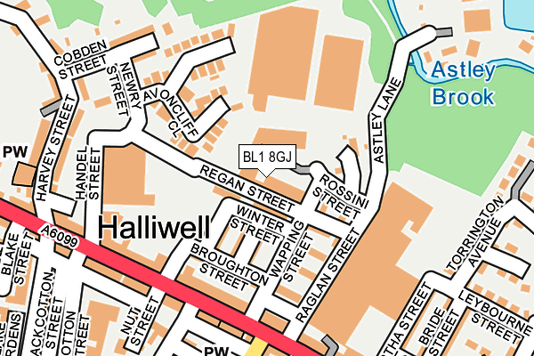
BL1 8GJ is located in the Halliwell electoral ward, within the metropolitan district of Bolton and the English Parliamentary constituency of Bolton North East. The Sub Integrated Care Board (ICB) Location is NHS Greater Manchester ICB - 00T and the police force is Greater Manchester. This postcode has been in use since September 2016.


GetTheData
Source: OS OpenMap – Local (Ordnance Survey)
Source: OS VectorMap District (Ordnance Survey)
Licence: Open Government Licence (requires attribution)
| Easting | 370822 |
| Northing | 411082 |
| Latitude | 53.595508 |
| Longitude | -2.442325 |
GetTheData
Source: Open Postcode Geo
Licence: Open Government Licence
| Country | England |
| Postcode District | BL1 |
| ➜ BL1 open data dashboard ➜ See where BL1 is on a map ➜ Where is Bolton? | |
GetTheData
Source: Land Registry Price Paid Data
Licence: Open Government Licence
Elevation or altitude of BL1 8GJ as distance above sea level:
| Metres | Feet | |
|---|---|---|
| Elevation | 120m | 394ft |
Elevation is measured from the approximate centre of the postcode, to the nearest point on an OS contour line from OS Terrain 50, which has contour spacing of ten vertical metres.
➜ How high above sea level am I? Find the elevation of your current position using your device's GPS.
GetTheData
Source: Open Postcode Elevation
Licence: Open Government Licence
| Ward | Halliwell |
| Constituency | Bolton North East |
GetTheData
Source: ONS Postcode Database
Licence: Open Government Licence
| May 2021 | Violence and sexual offences | On or near Back Collings Street | 310m |
| ➜ Get more crime data in our Crime section | |||
GetTheData
Source: data.police.uk
Licence: Open Government Licence
| Halliwell Road/Post Office (Halliwell Road) | Halliwell | 175m |
| Halliwell Road/Eskrick Street (Halliwell Road) | Halliwell | 190m |
| Halliwell Road/Robin Hood Inn (Halliwell Road) | Halliwell | 214m |
| Halliwell Road/Rushey Fold Lane (Halliwell Road) | Halliwell | 229m |
| Halliwell Road/Horace Street (Halliwell Road) | Halliwell | 341m |
| Hall i' th' Wood Station | 1.9km |
| Bolton Station | 2.6km |
| Bromley Cross Station | 2.9km |
GetTheData
Source: NaPTAN
Licence: Open Government Licence
GetTheData
Source: ONS Postcode Database
Licence: Open Government Licence


➜ Get more ratings from the Food Standards Agency
GetTheData
Source: Food Standards Agency
Licence: FSA terms & conditions
| Last Collection | |||
|---|---|---|---|
| Location | Mon-Fri | Sat | Distance |
| Bolton North Delivery Office | 18:45 | 12:25 | 599m |
| Tennyson Street | 17:10 | 11:10 | 609m |
| Bolton North Delivery Office | 18:45 | 682m | |
GetTheData
Source: Dracos
Licence: Creative Commons Attribution-ShareAlike
| Facility | Distance |
|---|---|
| Astley Bridge Cricket Club Moss Bank Way, Bolton Grass Pitches | 505m |
| Eden Boys School (Bolton) Wolfenden Street, Bolton Sports Hall, Artificial Grass Pitch, Health and Fitness Gym | 534m |
| Thornleigh Salesian College Sharples Park, Bolton Grass Pitches, Sports Hall, Artificial Grass Pitch | 658m |
GetTheData
Source: Active Places
Licence: Open Government Licence
| School | Phase of Education | Distance |
|---|---|---|
| St Thomas C of E Primary School, Halliwell Eskrick Street, Bolton, BL1 3JB | Primary | 376m |
| Eden Boys' School Bolton Wolfenden Street, Bolton, BL1 3QE | Secondary | 514m |
| Thornleigh Salesian College Sharples Park, Astley Bridge, Bolton, BL1 6PQ | Secondary | 658m |
GetTheData
Source: Edubase
Licence: Open Government Licence
The below table lists the International Territorial Level (ITL) codes (formerly Nomenclature of Territorial Units for Statistics (NUTS) codes) and Local Administrative Units (LAU) codes for BL1 8GJ:
| ITL 1 Code | Name |
|---|---|
| TLD | North West (England) |
| ITL 2 Code | Name |
| TLD3 | Greater Manchester |
| ITL 3 Code | Name |
| TLD36 | Greater Manchester North West |
| LAU 1 Code | Name |
| E08000001 | Bolton |
GetTheData
Source: ONS Postcode Directory
Licence: Open Government Licence
The below table lists the Census Output Area (OA), Lower Layer Super Output Area (LSOA), and Middle Layer Super Output Area (MSOA) for BL1 8GJ:
| Code | Name | |
|---|---|---|
| OA | E00024636 | |
| LSOA | E01004865 | Bolton 011D |
| MSOA | E02000994 | Bolton 011 |
GetTheData
Source: ONS Postcode Directory
Licence: Open Government Licence
| BL1 8AZ | Winter Street | 44m |
| BL1 8BA | Tennis Street | 84m |
| BL1 8AY | Duxbury Street | 84m |
| BL1 8BD | Avoncliff Close | 111m |
| BL1 8AR | Regan Street | 111m |
| BL1 8AX | Broughton Street | 125m |
| BL1 8AN | Halliwell Road | 157m |
| BL1 8DE | Halliwell Road | 190m |
| BL1 8BE | Cobden Street | 202m |
| BL1 3JR | Nut Street | 215m |
GetTheData
Source: Open Postcode Geo; Land Registry Price Paid Data
Licence: Open Government Licence