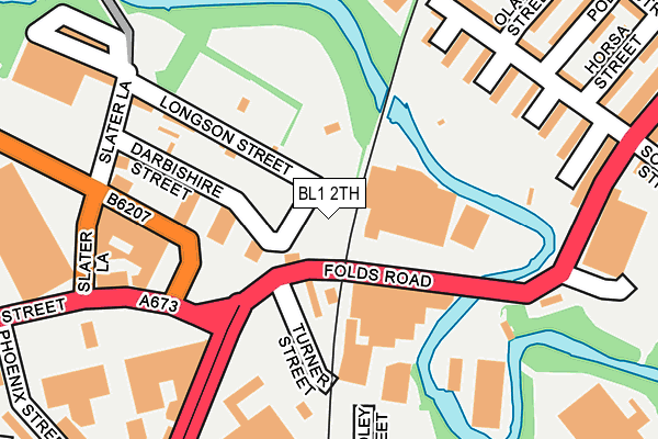
BL1 2TH is located in the Halliwell electoral ward, within the metropolitan district of Bolton and the English Parliamentary constituency of Bolton North East. The Sub Integrated Care Board (ICB) Location is NHS Greater Manchester ICB - 00T and the police force is Greater Manchester. This postcode has been in use since January 1992.


GetTheData
Source: OS OpenMap – Local (Ordnance Survey)
Source: OS VectorMap District (Ordnance Survey)
Licence: Open Government Licence (requires attribution)
| Easting | 372357 |
| Northing | 410004 |
| Latitude | 53.585902 |
| Longitude | -2.419037 |
GetTheData
Source: Open Postcode Geo
Licence: Open Government Licence
| Country | England |
| Postcode District | BL1 |
➜ See where BL1 is on a map ➜ Where is Bolton? | |
GetTheData
Source: Land Registry Price Paid Data
Licence: Open Government Licence
Elevation or altitude of BL1 2TH as distance above sea level:
| Metres | Feet | |
|---|---|---|
| Elevation | 90m | 295ft |
Elevation is measured from the approximate centre of the postcode, to the nearest point on an OS contour line from OS Terrain 50, which has contour spacing of ten vertical metres.
➜ How high above sea level am I? Find the elevation of your current position using your device's GPS.
GetTheData
Source: Open Postcode Elevation
Licence: Open Government Licence
| Ward | Halliwell |
| Constituency | Bolton North East |
GetTheData
Source: ONS Postcode Database
Licence: Open Government Licence
| Folds Rd/Turner St. (Folds Road) | Mill Hill | 47m |
| Folds Rd/Turner St. (Folds Road) | Mill Hill | 59m |
| Folds Rd/Waterloo St. (Folds Road) | Mill Hill | 185m |
| Tonge Moor Rd/Scowcroft St (Tonge Moor Rd) | Tonge Moor | 243m |
| Folds Rd/Turton St. (Folds Road) | Mill Hill | 256m |
| Hall i' th' Wood Station | 1.3km |
| Bolton Station | 1.4km |
| Bromley Cross Station | 3.2km |
GetTheData
Source: NaPTAN
Licence: Open Government Licence
GetTheData
Source: ONS Postcode Database
Licence: Open Government Licence


➜ Get more ratings from the Food Standards Agency
GetTheData
Source: Food Standards Agency
Licence: FSA terms & conditions
| Last Collection | |||
|---|---|---|---|
| Location | Mon-Fri | Sat | Distance |
| Waterloo Street | 17:45 | 12:25 | 203m |
| Cable Street | 17:40 | 12:25 | 407m |
| Ainsworth Lane P O | 17:20 | 12:00 | 723m |
GetTheData
Source: Dracos
Licence: Creative Commons Attribution-ShareAlike
The below table lists the International Territorial Level (ITL) codes (formerly Nomenclature of Territorial Units for Statistics (NUTS) codes) and Local Administrative Units (LAU) codes for BL1 2TH:
| ITL 1 Code | Name |
|---|---|
| TLD | North West (England) |
| ITL 2 Code | Name |
| TLD3 | Greater Manchester |
| ITL 3 Code | Name |
| TLD36 | Greater Manchester North West |
| LAU 1 Code | Name |
| E08000001 | Bolton |
GetTheData
Source: ONS Postcode Directory
Licence: Open Government Licence
The below table lists the Census Output Area (OA), Lower Layer Super Output Area (LSOA), and Middle Layer Super Output Area (MSOA) for BL1 2TH:
| Code | Name | |
|---|---|---|
| OA | E00024415 | |
| LSOA | E01033220 | Bolton 016F |
| MSOA | E02000999 | Bolton 016 |
GetTheData
Source: ONS Postcode Directory
Licence: Open Government Licence
| BL1 2TL | Longson Street | 81m |
| BL1 2TN | Darbishire Street | 102m |
| BL2 2DJ | Tonge Moor Road | 203m |
| BL2 2DR | Union Road | 237m |
| BL2 2DH | Tonge Moor Road | 244m |
| BL1 2TJ | Ryefield Street | 280m |
| BL2 2DY | Pole Street | 286m |
| BL2 2EB | Olaf Street | 296m |
| BL2 2UB | Grassington Place | 301m |
| BL2 2DW | Horsa Street | 304m |
GetTheData
Source: Open Postcode Geo; Land Registry Price Paid Data
Licence: Open Government Licence