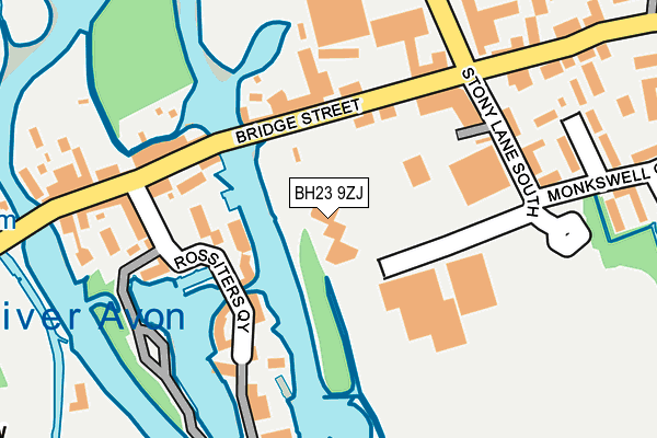
BH23 9ZJ is located in the Christchurch Town electoral ward, within the unitary authority of Bournemouth, Christchurch and Poole and the English Parliamentary constituency of Christchurch. The Sub Integrated Care Board (ICB) Location is NHS Dorset ICB - 11J and the police force is Dorset. This postcode has been in use since May 2017.


GetTheData
Source: OS OpenMap – Local (Ordnance Survey)
Source: OS VectorMap District (Ordnance Survey)
Licence: Open Government Licence (requires attribution)
| Easting | 416345 |
| Northing | 92758 |
| Latitude | 50.734199 |
| Longitude | -1.769750 |
GetTheData
Source: Open Postcode Geo
Licence: Open Government Licence
| Country | England |
| Postcode District | BH23 |
| ➜ BH23 open data dashboard ➜ See where BH23 is on a map ➜ Where is Christchurch? | |
GetTheData
Source: Land Registry Price Paid Data
Licence: Open Government Licence
| Ward | Christchurch Town |
| Constituency | Christchurch |
GetTheData
Source: ONS Postcode Database
Licence: Open Government Licence
| June 2022 | Bicycle theft | On or near Bridge Street | 105m |
| June 2022 | Vehicle crime | On or near Bridge Street | 105m |
| June 2022 | Other theft | On or near Stony Lane South | 176m |
| ➜ Get more crime data in our Crime section | |||
GetTheData
Source: data.police.uk
Licence: Open Government Licence
| Civic Offices | Purewell | 84m |
| Stony Lane (Bridge Street) | Purewell | 119m |
| Stony Lane (Bridge Street) | Purewell | 125m |
| Two Rivers Meet Leisure Centre | Purewell | 206m |
| Stony Lane | Purewell | 262m |
| Christchurch Station | 1.1km |
| Pokesdown Station | 3.9km |
| Hinton Admiral Station | 4.4km |
GetTheData
Source: NaPTAN
Licence: Open Government Licence
GetTheData
Source: ONS Postcode Database
Licence: Open Government Licence


➜ Get more ratings from the Food Standards Agency
GetTheData
Source: Food Standards Agency
Licence: FSA terms & conditions
| Last Collection | |||
|---|---|---|---|
| Location | Mon-Fri | Sat | Distance |
| Bridge Street | 16:45 | 12:45 | 122m |
| Salisbury Arms | 17:30 | 12:30 | 439m |
| High Street | 17:45 | 12:45 | 450m |
GetTheData
Source: Dracos
Licence: Creative Commons Attribution-ShareAlike
| Facility | Distance |
|---|---|
| Two Riversmeet Leisure Centre Stony Lane South, Christchurch Sports Hall, Swimming Pool, Health and Fitness Gym, Golf, Squash Courts, Artificial Grass Pitch | 123m |
| East Dorset Indoor Bowls Club Stony Lane South, Christchurch Indoor Bowls | 144m |
| Urban Health & Fitness (Christchurch) High Street, Christchurch Health and Fitness Gym, Studio | 473m |
GetTheData
Source: Active Places
Licence: Open Government Licence
| School | Phase of Education | Distance |
|---|---|---|
| Connie Rothman Learning Centre Christchurch Christian Centre, Millhams Street, Christchurch, BH23 1DN | Not applicable | 495m |
| The Priory Church of England Primary School Wick Lane, Christchurch, BH23 1HX | Primary | 604m |
| Mudeford Community Infants' School Queen's Road, Mudeford, Christchurch, BH23 3HH | Primary | 912m |
GetTheData
Source: Edubase
Licence: Open Government Licence
| Risk of BH23 9ZJ flooding from rivers and sea | Low |
| ➜ BH23 9ZJ flood map | |
GetTheData
Source: Open Flood Risk by Postcode
Licence: Open Government Licence
The below table lists the International Territorial Level (ITL) codes (formerly Nomenclature of Territorial Units for Statistics (NUTS) codes) and Local Administrative Units (LAU) codes for BH23 9ZJ:
| ITL 1 Code | Name |
|---|---|
| TLK | South West (England) |
| ITL 2 Code | Name |
| TLK2 | Dorset and Somerset |
| ITL 3 Code | Name |
| TLK24 | Bournemouth, Christchurch and Poole |
| LAU 1 Code | Name |
| E06000058 | Bournemouth, Christchurch and Poole |
GetTheData
Source: ONS Postcode Directory
Licence: Open Government Licence
The below table lists the Census Output Area (OA), Lower Layer Super Output Area (LSOA), and Middle Layer Super Output Area (MSOA) for BH23 9ZJ:
| Code | Name | |
|---|---|---|
| OA | E00103177 | |
| LSOA | E01020364 | Christchurch 006C |
| MSOA | E02004241 | Christchurch 006 |
GetTheData
Source: ONS Postcode Directory
Licence: Open Government Licence
| BH23 1EB | Bridge Street | 114m |
| BH23 1DJ | Avon Wharf | 116m |
| BH23 1DZ | Rossiters Quay | 133m |
| BH23 1DY | Bridge Street | 155m |
| BH23 1FA | Stony Lane South | 155m |
| BH23 1BL | Bridge Street | 182m |
| BH23 1HW | Stony Lane South | 193m |
| BH23 1AR | Purewell Gate | 224m |
| BH23 1FD | Tamlyns Farm Mews | 274m |
| BH23 1ED | Bridge Street | 276m |
GetTheData
Source: Open Postcode Geo; Land Registry Price Paid Data
Licence: Open Government Licence