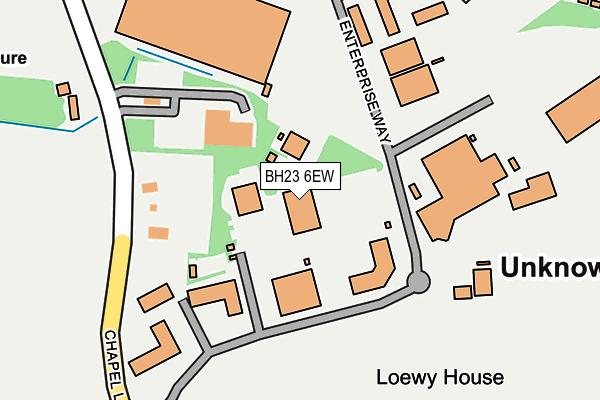
BH23 6EW is located in the Commons electoral ward, within the unitary authority of Bournemouth, Christchurch and Poole and the English Parliamentary constituency of Christchurch. The Sub Integrated Care Board (ICB) Location is NHS Dorset ICB - 11J and the police force is Dorset. This postcode has been in use since June 1999.


GetTheData
Source: OS OpenMap – Local (Ordnance Survey)
Source: OS VectorMap District (Ordnance Survey)
Licence: Open Government Licence (requires attribution)
| Easting | 410475 |
| Northing | 98023 |
| Latitude | 50.781690 |
| Longitude | -1.852786 |
GetTheData
Source: Open Postcode Geo
Licence: Open Government Licence
| Country | England |
| Postcode District | BH23 |
| ➜ BH23 open data dashboard ➜ See where BH23 is on a map | |
GetTheData
Source: Land Registry Price Paid Data
Licence: Open Government Licence
Elevation or altitude of BH23 6EW as distance above sea level:
| Metres | Feet | |
|---|---|---|
| Elevation | 10m | 33ft |
Elevation is measured from the approximate centre of the postcode, to the nearest point on an OS contour line from OS Terrain 50, which has contour spacing of ten vertical metres.
➜ How high above sea level am I? Find the elevation of your current position using your device's GPS.
GetTheData
Source: Open Postcode Elevation
Licence: Open Government Licence
| Ward | Commons |
| Constituency | Christchurch |
GetTheData
Source: ONS Postcode Database
Licence: Open Government Licence
| June 2022 | Violence and sexual offences | On or near Sports/Recreation Area | 473m |
| June 2022 | Violence and sexual offences | On or near Sports/Recreation Area | 473m |
| June 2022 | Drugs | On or near Sports/Recreation Area | 473m |
| ➜ Get more crime data in our Crime section | |||
GetTheData
Source: data.police.uk
Licence: Open Government Licence
| Enterprise Way | East Parley | 116m |
| Aviation Business Park | East Parley | 254m |
| Chapel Gate | East Parley | 496m |
| Chapel Gate | East Parley | 510m |
| Parley Court Farm (Hurn Lane) | Parley Green | 654m |
| Christchurch Station | 6.8km |
GetTheData
Source: NaPTAN
Licence: Open Government Licence
GetTheData
Source: ONS Postcode Database
Licence: Open Government Licence


➜ Get more ratings from the Food Standards Agency
GetTheData
Source: Food Standards Agency
Licence: FSA terms & conditions
| Last Collection | |||
|---|---|---|---|
| Location | Mon-Fri | Sat | Distance |
| Hurn Airport | 113m | ||
| Hurn Airport West | 17:00 | 12:00 | 113m |
| Parley Green | 16:00 | 12:00 | 703m |
GetTheData
Source: Dracos
Licence: Creative Commons Attribution-ShareAlike
| Facility | Distance |
|---|---|
| Chapel Gate Chapel Gate, Parley, Christchurch Artificial Grass Pitch, Health and Fitness Gym, Grass Pitches, Squash Courts | 456m |
| Parley Golf Centre Parley Green Lane, Parley, Christchurch Golf | 654m |
| Parkfield School Hurn, Christchurch Sports Hall | 1.5km |
GetTheData
Source: Active Places
Licence: Open Government Licence
| School | Phase of Education | Distance |
|---|---|---|
| Portfield School Parley Lane, Christchurch, BH23 6BP | Not applicable | 800m |
| Parkfield School Hurn, Christchurch, BH23 6DF | All-through | 1.5km |
| The Epiphany School Shillingstone Drive, Muscliff, Bournemouth, BH9 3PE | Primary | 2.2km |
GetTheData
Source: Edubase
Licence: Open Government Licence
The below table lists the International Territorial Level (ITL) codes (formerly Nomenclature of Territorial Units for Statistics (NUTS) codes) and Local Administrative Units (LAU) codes for BH23 6EW:
| ITL 1 Code | Name |
|---|---|
| TLK | South West (England) |
| ITL 2 Code | Name |
| TLK2 | Dorset and Somerset |
| ITL 3 Code | Name |
| TLK24 | Bournemouth, Christchurch and Poole |
| LAU 1 Code | Name |
| E06000058 | Bournemouth, Christchurch and Poole |
GetTheData
Source: ONS Postcode Directory
Licence: Open Government Licence
The below table lists the Census Output Area (OA), Lower Layer Super Output Area (LSOA), and Middle Layer Super Output Area (MSOA) for BH23 6EW:
| Code | Name | |
|---|---|---|
| OA | E00103199 | |
| LSOA | E01020365 | Christchurch 001D |
| MSOA | E02004236 | Christchurch 001 |
GetTheData
Source: ONS Postcode Directory
Licence: Open Government Licence
| BH23 6HG | Enterprise Way | 56m |
| BH23 6BB | Parley Green Lane | 894m |
| BH22 8SJ | Christchurch Road | 964m |
| BH23 6NE | North East Sector | 1231m |
| BH22 8UB | Barrack Road | 1280m |
| BH22 8SW | Christchurch Road | 1337m |
| BH23 6AZ | 1386m | |
| BH22 8SN | Christchurch Road | 1459m |
| BH23 6AY | Hurn Court Lane | 1652m |
| BH22 8TS | Church Lane | 1680m |
GetTheData
Source: Open Postcode Geo; Land Registry Price Paid Data
Licence: Open Government Licence