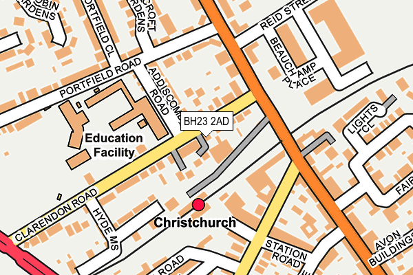
BH23 2AD is located in the Christchurch Town electoral ward, within the unitary authority of Bournemouth, Christchurch and Poole and the English Parliamentary constituency of Christchurch. The Sub Integrated Care Board (ICB) Location is NHS Dorset ICB - 11J and the police force is Dorset. This postcode has been in use since December 1999.


GetTheData
Source: OS OpenMap – Local (Ordnance Survey)
Source: OS VectorMap District (Ordnance Survey)
Licence: Open Government Licence (requires attribution)
| Easting | 415310 |
| Northing | 93322 |
| Latitude | 50.739309 |
| Longitude | -1.784399 |
GetTheData
Source: Open Postcode Geo
Licence: Open Government Licence
| Country | England |
| Postcode District | BH23 |
| ➜ BH23 open data dashboard ➜ See where BH23 is on a map ➜ Where is Christchurch? | |
GetTheData
Source: Land Registry Price Paid Data
Licence: Open Government Licence
Elevation or altitude of BH23 2AD as distance above sea level:
| Metres | Feet | |
|---|---|---|
| Elevation | 10m | 33ft |
Elevation is measured from the approximate centre of the postcode, to the nearest point on an OS contour line from OS Terrain 50, which has contour spacing of ten vertical metres.
➜ How high above sea level am I? Find the elevation of your current position using your device's GPS.
GetTheData
Source: Open Postcode Elevation
Licence: Open Government Licence
| Ward | Christchurch Town |
| Constituency | Christchurch |
GetTheData
Source: ONS Postcode Database
Licence: Open Government Licence
| June 2022 | Violence and sexual offences | On or near Clarendon Road | 118m |
| June 2022 | Violence and sexual offences | On or near Fairmile Road | 125m |
| June 2022 | Violence and sexual offences | On or near Fairmile Road | 125m |
| ➜ Get more crime data in our Crime section | |||
GetTheData
Source: data.police.uk
Licence: Open Government Licence
| Junior And Infant Schools (Clarendon Road) | Jumpers Common | 124m |
| Junior And Infant Schools (Clarendon Road) | Jumpers Common | 129m |
| Christchurch Railway Station (Stour Road) | Christchurch | 160m |
| Christchurch Railway Station (Stour Road) | Christchurch | 170m |
| Fairfield (Bargates) | Christchurch | 185m |
| Christchurch Station | 0.1km |
| Pokesdown Station | 3km |
| Hinton Admiral Station | 5.2km |
GetTheData
Source: NaPTAN
Licence: Open Government Licence
GetTheData
Source: ONS Postcode Database
Licence: Open Government Licence


➜ Get more ratings from the Food Standards Agency
GetTheData
Source: Food Standards Agency
Licence: FSA terms & conditions
| Last Collection | |||
|---|---|---|---|
| Location | Mon-Fri | Sat | Distance |
| Railway Station | 17:00 | 12:30 | 115m |
| Bargates P.o. | 17:00 | 12:45 | 253m |
| Barrack Road East | 17:15 | 12:30 | 327m |
GetTheData
Source: Dracos
Licence: Creative Commons Attribution-ShareAlike
| Facility | Distance |
|---|---|
| Christchurch Junior School Clarendon Road, Christchurch Grass Pitches | 202m |
| Christchurch Recreation Ground Magdalen Lane, Christchurch Grass Pitches | 516m |
| Twynham School Sopers Lane, Christchurch Sports Hall, Swimming Pool, Grass Pitches, Studio | 664m |
GetTheData
Source: Active Places
Licence: Open Government Licence
| School | Phase of Education | Distance |
|---|---|---|
| Christchurch Infant School Addiscombe Road, Christchurch, BH23 2AE | Primary | 164m |
| Christchurch Junior School Clarendon Road, Christchurch, BH23 2AA | Primary | 207m |
| Christchurch Learning Centre 29 Stour Road, Christchurch, BH23 1PJ | Not applicable | 219m |
GetTheData
Source: Edubase
Licence: Open Government Licence
The below table lists the International Territorial Level (ITL) codes (formerly Nomenclature of Territorial Units for Statistics (NUTS) codes) and Local Administrative Units (LAU) codes for BH23 2AD:
| ITL 1 Code | Name |
|---|---|
| TLK | South West (England) |
| ITL 2 Code | Name |
| TLK2 | Dorset and Somerset |
| ITL 3 Code | Name |
| TLK24 | Bournemouth, Christchurch and Poole |
| LAU 1 Code | Name |
| E06000058 | Bournemouth, Christchurch and Poole |
GetTheData
Source: ONS Postcode Directory
Licence: Open Government Licence
The below table lists the Census Output Area (OA), Lower Layer Super Output Area (LSOA), and Middle Layer Super Output Area (MSOA) for BH23 2AD:
| Code | Name | |
|---|---|---|
| OA | E00103162 | |
| LSOA | E01020360 | Christchurch 006A |
| MSOA | E02004241 | Christchurch 006 |
GetTheData
Source: ONS Postcode Directory
Licence: Open Government Licence
| BH23 2AA | Clarendon Road | 40m |
| BH23 2LJ | Fairmile Road | 86m |
| BH23 2AE | Addiscombe Road | 94m |
| BH23 2AB | Clarendon Road | 109m |
| BH23 1PL | Stour Road | 140m |
| BH23 1QH | Bargates | 157m |
| BH23 2AQ | Portfield Road | 158m |
| BH23 2FF | Hyde Mews | 183m |
| BH23 2LA | Fairmile Road | 184m |
| BH23 1QY | Station Road | 192m |
GetTheData
Source: Open Postcode Geo; Land Registry Price Paid Data
Licence: Open Government Licence