
BH10 4FH maps, stats, and open data
BH10 4FH lies on Orchard Gardens in Bournemouth. BH10 4FH is located in the Wallisdown & Winton West electoral ward, within the unitary authority of Bournemouth, Christchurch and Poole and the English Parliamentary constituency of Bournemouth West. The Sub Integrated Care Board (ICB) Location is NHS Dorset ICB - 11J and the police force is Dorset. This postcode has been in use since June 2010.
BH10 4FH maps

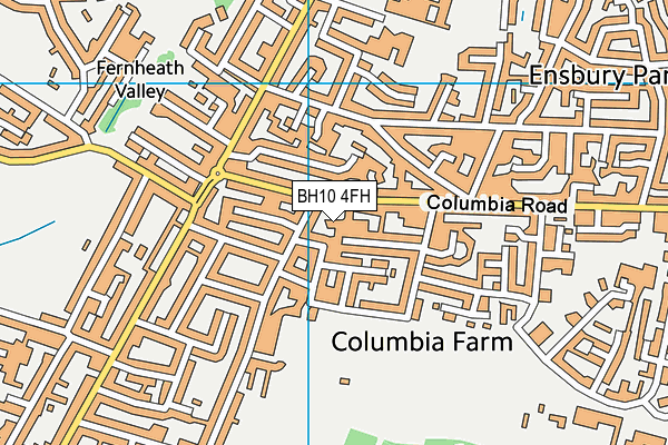
Source: OS VectorMap District (Ordnance Survey)
Licence: Open Government Licence (requires attribution)
BH10 4FH geodata
| Easting | 407061 |
| Northing | 94686 |
| Latitude | 50.751732 |
| Longitude | -1.901274 |
Where is BH10 4FH?
| Street | Orchard Gardens |
| Town/City | Bournemouth |
| Country | England |
| Postcode District | BH10 |
BH10 4FH Elevation
Elevation or altitude of BH10 4FH as distance above sea level:
| Metres | Feet | |
|---|---|---|
| Elevation | 40m | 131ft |
Elevation is measured from the approximate centre of the postcode, to the nearest point on an OS contour line from OS Terrain 50, which has contour spacing of ten vertical metres.
➜ How high above sea level am I? Find the elevation of your current position using your device's GPS.
Politics
| Ward | Wallisdown & Winton West |
|---|---|
| Constituency | Bournemouth West |
House Prices
Sales of detached houses in BH10 4FH
1, ORCHARD GARDENS, BOURNEMOUTH, BH10 4FH 2010 29 OCT £190,000 |
Licence: Contains HM Land Registry data © Crown copyright and database right 2026. This data is licensed under the Open Government Licence v3.0.
Transport
Nearest bus stops to BH10 4FH
| Priestley Road (Columbia Road) | East Howe | 50m |
| Priestley Road (Columbia Road) | East Howe | 73m |
| Columbia Road | East Howe | 235m |
| Howeth Road (Columbia Road) | Ensbury Park | 264m |
| Cherford Road (Kinson Road) | East Howe | 308m |
Nearest railway stations to BH10 4FH
| Branksome Station | 3km |
| Bournemouth Station | 3.8km |
| Parkstone (Dorset) Station | 4.6km |
Broadband
Broadband access in BH10 4FH (2020 data)
| Percentage of properties with Next Generation Access | 100.0% |
| Percentage of properties with Superfast Broadband | 100.0% |
| Percentage of properties with Ultrafast Broadband | 100.0% |
| Percentage of properties with Full Fibre Broadband | 0.0% |
Superfast Broadband is between 30Mbps and 300Mbps
Ultrafast Broadband is > 300Mbps
Broadband speed in BH10 4FH (2019 data)
Download
| Median download speed | 65.0Mbps |
| Average download speed | 65.3Mbps |
| Maximum download speed | 150.00Mbps |
Upload
| Median upload speed | 10.5Mbps |
| Average upload speed | 10.4Mbps |
| Maximum upload speed | 20.00Mbps |
Broadband limitations in BH10 4FH (2020 data)
| Percentage of properties unable to receive 2Mbps | 0.0% |
| Percentage of properties unable to receive 5Mbps | 0.0% |
| Percentage of properties unable to receive 10Mbps | 0.0% |
| Percentage of properties unable to receive 30Mbps | 0.0% |
BH10 4FH gas and electricity consumption
Estimated total energy consumption in BH10 4FH by fuel type, 2015.
Electricity
| Consumption (kWh) | 25,869 |
|---|---|
| Meter count | 9 |
| Mean (kWh/meter) | 2,874 |
| Median (kWh/meter) | 2,358 |
- Consumption: The estimated total energy consumption, in kWh, across all meters in BH10 4FH, for 2015.
- Meter count: The total number of meters in BH10 4FH.
- Mean: The mean average consumption per meter, in kWh.
- Median: The median average consumption per meter, in kWh.
Source: Postcode level electricity estimates: 2015 (experimental)
Licence: Open Government Licence
Deprivation
76.2% of English postcodes are less deprived than BH10 4FH:Food Standards Agency
Three nearest food hygiene ratings to BH10 4FH (metres)
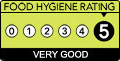
➜ Get more ratings from the Food Standards Agency
Nearest post box to BH10 4FH
| Last Collection | |||
|---|---|---|---|
| Location | Mon-Fri | Sat | Distance |
| 204 Columbia Road | 17:30 | 11:30 | 131m |
| Gwyne Road | 17:30 | 12:15 | 226m |
| 9 Kingsbere Ave | 17:30 | 11:30 | 248m |
BH10 4FH ITL and BH10 4FH LAU
The below table lists the International Territorial Level (ITL) codes (formerly Nomenclature of Territorial Units for Statistics (NUTS) codes) and Local Administrative Units (LAU) codes for BH10 4FH:
| ITL 1 Code | Name |
|---|---|
| TLK | South West (England) |
| ITL 2 Code | Name |
| TLK2 | Dorset and Somerset |
| ITL 3 Code | Name |
| TLK24 | Bournemouth, Christchurch and Poole |
| LAU 1 Code | Name |
| E06000058 | Bournemouth, Christchurch and Poole |
BH10 4FH census areas
The below table lists the Census Output Area (OA), Lower Layer Super Output Area (LSOA), and Middle Layer Super Output Area (MSOA) for BH10 4FH:
| Code | Name | |
|---|---|---|
| OA | E00077632 | |
| LSOA | E01015357 | Bournemouth 007D |
| MSOA | E02003178 | Bournemouth 007 |
Nearest postcodes to BH10 4FH
| BH10 4FD | Orchard Walk | 48m |
| BH10 4AX | Priestley Road | 49m |
| BH10 4BD | St Margarets Road | 51m |
| BH10 4GE | Columbia Road | 59m |
| BH10 4BE | St Margarets Road | 91m |
| BH10 4DS | Columbia Road | 98m |
| BH10 4JB | Furze Bank Lane | 108m |
| BH10 4BN | Cove Road | 112m |
| BH10 4AR | Priestley Road | 113m |
| BH10 4BB | Parham Road | 122m |


- Contains OS data © Crown copyright and database right (2026)
- Contains Royal Mail data © Royal Mail copyright and Database right (2026)
- Contains National Statistics data © Crown copyright and database right (2026)
- Data produced by Land Registry © Crown copyright (2026)
- Contains Environment Agency data licensed under the Open Government Licence v3.0
- Everything else © GetTheData Publishing Limited (2026)
GetTheData.com is owned and operated by GetTheData Publishing Limited.
Company Number: 11075184 · Registered in England and Wales.
Registered Office: 3rd Floor, 86-90 Paul Street, London, England, EC2A 4NE
By accessing our site you agree to us using cookies, and sharing information about your use of our site, in accordance with our privacy policy.