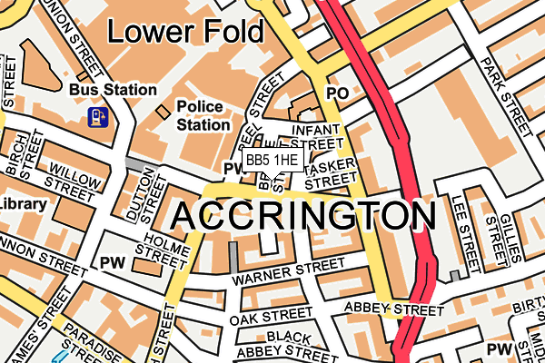
BB5 1HE is located in the Barnfield electoral ward, within the local authority district of Hyndburn and the English Parliamentary constituency of Hyndburn. The Sub Integrated Care Board (ICB) Location is NHS Lancashire and South Cumbria ICB - 01A and the police force is Lancashire. This postcode has been in use since January 1980.


GetTheData
Source: OS OpenMap – Local (Ordnance Survey)
Source: OS VectorMap District (Ordnance Survey)
Licence: Open Government Licence (requires attribution)
| Easting | 376149 |
| Northing | 428558 |
| Latitude | 53.752836 |
| Longitude | -2.363192 |
GetTheData
Source: Open Postcode Geo
Licence: Open Government Licence
| Country | England |
| Postcode District | BB5 |
| ➜ BB5 open data dashboard ➜ See where BB5 is on a map ➜ Where is Accrington? | |
GetTheData
Source: Land Registry Price Paid Data
Licence: Open Government Licence
Elevation or altitude of BB5 1HE as distance above sea level:
| Metres | Feet | |
|---|---|---|
| Elevation | 140m | 459ft |
Elevation is measured from the approximate centre of the postcode, to the nearest point on an OS contour line from OS Terrain 50, which has contour spacing of ten vertical metres.
➜ How high above sea level am I? Find the elevation of your current position using your device's GPS.
GetTheData
Source: Open Postcode Elevation
Licence: Open Government Licence
| Ward | Barnfield |
| Constituency | Hyndburn |
GetTheData
Source: ONS Postcode Database
Licence: Open Government Licence
| January 2024 | Anti-social behaviour | On or near Gillies Street | 261m |
| January 2024 | Criminal damage and arson | On or near Gillies Street | 261m |
| January 2024 | Violence and sexual offences | On or near Gillies Street | 261m |
| ➜ Get more crime data in our Crime section | |||
GetTheData
Source: data.police.uk
Licence: Open Government Licence
| Market (Blackburn Road) | Accrington | 21m |
| Infant Street (Abbey St) | Accrington | 94m |
| Warner Street (Abbey Street) | Accrington | 151m |
| Eastgate (Avenue Parade) | Accrington | 202m |
| Church Street | Accrington | 229m |
| Accrington Station | 0.4km |
| Church & Oswaldtwistle Station | 1.9km |
| Huncoat Station | 2.3km |
GetTheData
Source: NaPTAN
Licence: Open Government Licence
GetTheData
Source: ONS Postcode Database
Licence: Open Government Licence


➜ Get more ratings from the Food Standards Agency
GetTheData
Source: Food Standards Agency
Licence: FSA terms & conditions
| Last Collection | |||
|---|---|---|---|
| Location | Mon-Fri | Sat | Distance |
| 52 Lancaster Avenue | 16:15 | 11:15 | 1,393m |
| Oswaldtwistle P.o. | 16:30 | 12:00 | 2,470m |
| Clayton Le Moors Post Office | 16:45 | 12:15 | 2,608m |
GetTheData
Source: Dracos
Licence: Creative Commons Attribution-ShareAlike
| Facility | Distance |
|---|---|
| The Zone Hyndburn New Era Complex Paradise Street, Accrington Health and Fitness Gym, Sports Hall | 244m |
| The Gym Group (Accrington) Eastgate, Accrington Health and Fitness Gym | 252m |
| Central Fitness Centre Blackburn Road, Accrington Health and Fitness Gym | 387m |
GetTheData
Source: Active Places
Licence: Open Government Licence
| School | Phase of Education | Distance |
|---|---|---|
| Accrington Benjamin Hargreaves Voluntary Aided Church of England Primary School Barnfield Street, Accrington, BB5 2AQ | Primary | 497m |
| Accrington St John with St Augustine Church of England Primary School Maudsley Street, Accrington, BB5 6AD | Primary | 595m |
| Accrington St Mary Magdalen's Church of England Primary School Devonshire Street, Accrington, BB5 1DW | Primary | 684m |
GetTheData
Source: Edubase
Licence: Open Government Licence
The below table lists the International Territorial Level (ITL) codes (formerly Nomenclature of Territorial Units for Statistics (NUTS) codes) and Local Administrative Units (LAU) codes for BB5 1HE:
| ITL 1 Code | Name |
|---|---|
| TLD | North West (England) |
| ITL 2 Code | Name |
| TLD4 | Lancashire |
| ITL 3 Code | Name |
| TLD46 | East Lancashire |
| LAU 1 Code | Name |
| E07000120 | Hyndburn |
GetTheData
Source: ONS Postcode Directory
Licence: Open Government Licence
The below table lists the Census Output Area (OA), Lower Layer Super Output Area (LSOA), and Middle Layer Super Output Area (MSOA) for BB5 1HE:
| Code | Name | |
|---|---|---|
| OA | E00127065 | |
| LSOA | E01025036 | Hyndburn 008B |
| MSOA | E02005219 | Hyndburn 008 |
GetTheData
Source: ONS Postcode Directory
Licence: Open Government Licence
| BB5 1HD | Blackburn Road | 14m |
| BB5 1HL | Bridge Street | 20m |
| BB5 1HF | Blackburn Road | 41m |
| BB5 1HP | Bank Street | 71m |
| BB5 1EB | Abbey Street | 75m |
| BB5 1DZ | Infant Street | 77m |
| BB5 1EA | Peel Street | 87m |
| BB5 1HN | Warner Street | 91m |
| BB5 1EN | Abbey Street | 102m |
| BB5 2EH | Church Street | 103m |
GetTheData
Source: Open Postcode Geo; Land Registry Price Paid Data
Licence: Open Government Licence