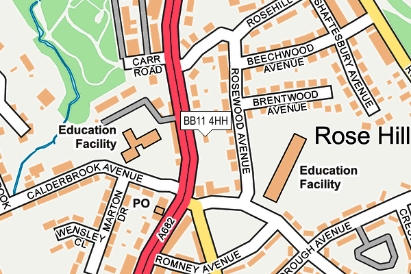
BB11 4HH is located in the Rosehill with Burnley Wood electoral ward, within the local authority district of Burnley and the English Parliamentary constituency of Burnley. The Sub Integrated Care Board (ICB) Location is NHS Lancashire and South Cumbria ICB - 01A and the police force is Lancashire. This postcode has been in use since January 1980.


GetTheData
Source: OS OpenMap – Local (Ordnance Survey)
Source: OS VectorMap District (Ordnance Survey)
Licence: Open Government Licence (requires attribution)
| Easting | 383374 |
| Northing | 431273 |
| Latitude | 53.777535 |
| Longitude | -2.253770 |
GetTheData
Source: Open Postcode Geo
Licence: Open Government Licence
| Country | England |
| Postcode District | BB11 |
| ➜ BB11 open data dashboard ➜ See where BB11 is on a map ➜ Where is Burnley? | |
GetTheData
Source: Land Registry Price Paid Data
Licence: Open Government Licence
Elevation or altitude of BB11 4HH as distance above sea level:
| Metres | Feet | |
|---|---|---|
| Elevation | 210m | 689ft |
Elevation is measured from the approximate centre of the postcode, to the nearest point on an OS contour line from OS Terrain 50, which has contour spacing of ten vertical metres.
➜ How high above sea level am I? Find the elevation of your current position using your device's GPS.
GetTheData
Source: Open Postcode Elevation
Licence: Open Government Licence
| Ward | Rosehill With Burnley Wood |
| Constituency | Burnley |
GetTheData
Source: ONS Postcode Database
Licence: Open Government Licence
| June 2022 | Violence and sexual offences | On or near Romney Avenue | 116m |
| June 2022 | Anti-social behaviour | On or near Gainsborough Avenue | 190m |
| June 2022 | Violence and sexual offences | On or near Gainsborough Avenue | 190m |
| ➜ Get more crime data in our Crime section | |||
GetTheData
Source: data.police.uk
Licence: Open Government Licence
| Rose And Crown (Manchester Road) | Rosehill | 10m |
| Rose And Crown (Manchester Road) | Rosehill | 71m |
| Rosewood Avenue (Moorland Road) | Rosehill | 78m |
| Rose Hill Avenue (Manchester Road) | Rosehill | 169m |
| Gainsborough Avenue (Manchester Road) | Rosehill | 177m |
| Burnley Manchester Road Station | 0.9km |
| Burnley Barracks Station | 1.5km |
| Burnley Central Station | 1.9km |
GetTheData
Source: NaPTAN
Licence: Open Government Licence
GetTheData
Source: ONS Postcode Database
Licence: Open Government Licence


➜ Get more ratings from the Food Standards Agency
GetTheData
Source: Food Standards Agency
Licence: FSA terms & conditions
| Last Collection | |||
|---|---|---|---|
| Location | Mon-Fri | Sat | Distance |
| Burnley Post Office | 18:30 | 11:00 | 1,386m |
| Burnley Post Office | 18:30 | 11:00 | 1,387m |
| Burnley Delivery Office | 19:00 | 13:00 | 1,410m |
GetTheData
Source: Dracos
Licence: Creative Commons Attribution-ShareAlike
| Facility | Distance |
|---|---|
| Christ The King Rc Primary School Calderbrook Avenue, Burnley Grass Pitches | 111m |
| Scott Park Western Avenue, Burnley Outdoor Tennis Courts | 564m |
| Burnley Golf Club Glen View Road, Burnley Golf | 661m |
GetTheData
Source: Active Places
Licence: Open Government Licence
| School | Phase of Education | Distance |
|---|---|---|
| Christ The King Roman Catholic Primary School, a Voluntary Academy Calderbrook Avenue, Burnley, BB11 4RB | Primary | 111m |
| Rosewood Primary School Rosewood Avenue, Rosewood Primary School, Burnley, BB11 2PH | Primary | 280m |
| The Rose School Greenock Street, Burnley, BB11 4DT | Not applicable | 801m |
GetTheData
Source: Edubase
Licence: Open Government Licence
The below table lists the International Territorial Level (ITL) codes (formerly Nomenclature of Territorial Units for Statistics (NUTS) codes) and Local Administrative Units (LAU) codes for BB11 4HH:
| ITL 1 Code | Name |
|---|---|
| TLD | North West (England) |
| ITL 2 Code | Name |
| TLD4 | Lancashire |
| ITL 3 Code | Name |
| TLD46 | East Lancashire |
| LAU 1 Code | Name |
| E07000117 | Burnley |
GetTheData
Source: ONS Postcode Directory
Licence: Open Government Licence
The below table lists the Census Output Area (OA), Lower Layer Super Output Area (LSOA), and Middle Layer Super Output Area (MSOA) for BB11 4HH:
| Code | Name | |
|---|---|---|
| OA | E00126413 | |
| LSOA | E01024905 | Burnley 014G |
| MSOA | E02006881 | Burnley 014 |
GetTheData
Source: ONS Postcode Directory
Licence: Open Government Licence
| BB11 2PQ | Moorland Road | 29m |
| BB11 4HL | Manchester Road | 103m |
| BB11 2NJ | Reynolds Street | 112m |
| BB11 4HD | Manchester Road | 118m |
| BB11 2PH | Rosewood Avenue | 123m |
| BB11 4HQ | Rosehill Mount | 124m |
| BB11 4HG | Manchester Road | 131m |
| BB11 2PG | Romney Avenue | 133m |
| BB11 2PF | Romney Avenue | 134m |
| BB11 4RE | Marton Drive | 147m |
GetTheData
Source: Open Postcode Geo; Land Registry Price Paid Data
Licence: Open Government Licence