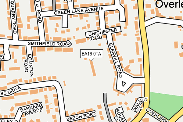
BA16 0TA is located in the Street electoral ward, within the unitary authority of Somerset and the English Parliamentary constituency of Wells. The Sub Integrated Care Board (ICB) Location is NHS Somerset ICB - 11X and the police force is Avon and Somerset. This postcode has been in use since February 1990.


GetTheData
Source: OS OpenMap – Local (Ordnance Survey)
Source: OS VectorMap District (Ordnance Survey)
Licence: Open Government Licence (requires attribution)
| Easting | 348078 |
| Northing | 135503 |
| Latitude | 51.116451 |
| Longitude | -2.743169 |
GetTheData
Source: Open Postcode Geo
Licence: Open Government Licence
| Country | England |
| Postcode District | BA16 |
| ➜ BA16 open data dashboard ➜ See where BA16 is on a map ➜ Where is Street? | |
GetTheData
Source: Land Registry Price Paid Data
Licence: Open Government Licence
Elevation or altitude of BA16 0TA as distance above sea level:
| Metres | Feet | |
|---|---|---|
| Elevation | 40m | 131ft |
Elevation is measured from the approximate centre of the postcode, to the nearest point on an OS contour line from OS Terrain 50, which has contour spacing of ten vertical metres.
➜ How high above sea level am I? Find the elevation of your current position using your device's GPS.
GetTheData
Source: Open Postcode Elevation
Licence: Open Government Licence
| Ward | Street |
| Constituency | Wells |
GetTheData
Source: ONS Postcode Database
Licence: Open Government Licence
| November 2023 | Violence and sexual offences | On or near Goss Drive | 290m |
| September 2023 | Violence and sexual offences | On or near Goss Drive | 290m |
| April 2023 | Violence and sexual offences | On or near Goss Drive | 290m |
| ➜ Get more crime data in our Crime section | |||
GetTheData
Source: data.police.uk
Licence: Open Government Licence
| Green Lane Avenue (Oakfield Road) | Street | 220m |
| Streets Glass | Street | 222m |
| Green Lane Avenue (Oakfield Road) | Street | 238m |
| Overleigh | Street | 239m |
| Green Lane (Ivythorn Road) | Street | 300m |
GetTheData
Source: NaPTAN
Licence: Open Government Licence
GetTheData
Source: ONS Postcode Database
Licence: Open Government Licence


➜ Get more ratings from the Food Standards Agency
GetTheData
Source: Food Standards Agency
Licence: FSA terms & conditions
| Last Collection | |||
|---|---|---|---|
| Location | Mon-Fri | Sat | Distance |
| Goss Drive | 17:30 | 12:00 | 281m |
| Cranhill Road | 16:00 | 11:30 | 1,113m |
| Street Post Office | 18:00 | 12:00 | 1,126m |
GetTheData
Source: Dracos
Licence: Creative Commons Attribution-ShareAlike
| Facility | Distance |
|---|---|
| The Tannery Ground (Street Fc) Middle Brooks, Street Grass Pitches | 24m |
| Avalon School Brooks Road, Street Sports Hall | 425m |
| Brookside Academy Brooks Road, Street Grass Pitches | 438m |
GetTheData
Source: Active Places
Licence: Open Government Licence
| School | Phase of Education | Distance |
|---|---|---|
| Avalon School Brooks Road, Street, BA16 0PS | Not applicable | 425m |
| Brookside Community Primary School Brooks Road, Street, BA16 0PR | Primary | 438m |
| Hindhayes Infant School Leigh Road, Street, BA16 0HB | Primary | 925m |
GetTheData
Source: Edubase
Licence: Open Government Licence
The below table lists the International Territorial Level (ITL) codes (formerly Nomenclature of Territorial Units for Statistics (NUTS) codes) and Local Administrative Units (LAU) codes for BA16 0TA:
| ITL 1 Code | Name |
|---|---|
| TLK | South West (England) |
| ITL 2 Code | Name |
| TLK2 | Dorset and Somerset |
| ITL 3 Code | Name |
| TLK23 | Somerset CC |
| LAU 1 Code | Name |
| E07000187 | Mendip |
GetTheData
Source: ONS Postcode Directory
Licence: Open Government Licence
The below table lists the Census Output Area (OA), Lower Layer Super Output Area (LSOA), and Middle Layer Super Output Area (MSOA) for BA16 0TA:
| Code | Name | |
|---|---|---|
| OA | E00148082 | |
| LSOA | E01029076 | Mendip 012E |
| MSOA | E02006058 | Mendip 012 |
GetTheData
Source: ONS Postcode Directory
Licence: Open Government Licence
| BA16 0TN | Glanvill Road | 101m |
| BA16 0QX | Chichester Road | 111m |
| BA16 0RG | Smithfield Road | 151m |
| BA16 0TL | Overleigh | 157m |
| BA16 0UH | Aquara Close | 174m |
| BA16 0QT | Green Lane Avenue | 182m |
| BA16 0QS | Green Lane Avenue | 182m |
| BA16 0RR | Goss Drive | 183m |
| BA16 0QU | Green Lane Avenue | 186m |
| BA16 0RY | Beech Road | 193m |
GetTheData
Source: Open Postcode Geo; Land Registry Price Paid Data
Licence: Open Government Licence