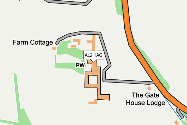
AL2 1AG is located in the London Colney electoral ward, within the local authority district of St Albans and the English Parliamentary constituency of St Albans. The Sub Integrated Care Board (ICB) Location is NHS Hertfordshire and West Essex ICB - 06N and the police force is Hertfordshire. This postcode has been in use since January 1980.


GetTheData
Source: OS OpenMap – Local (Ordnance Survey)
Source: OS VectorMap District (Ordnance Survey)
Licence: Open Government Licence (requires attribution)
| Easting | 517498 |
| Northing | 202817 |
| Latitude | 51.711796 |
| Longitude | -0.300731 |
GetTheData
Source: Open Postcode Geo
Licence: Open Government Licence
| Country | England |
| Postcode District | AL2 |
| ➜ AL2 open data dashboard ➜ See where AL2 is on a map | |
GetTheData
Source: Land Registry Price Paid Data
Licence: Open Government Licence
Elevation or altitude of AL2 1AG as distance above sea level:
| Metres | Feet | |
|---|---|---|
| Elevation | 70m | 230ft |
Elevation is measured from the approximate centre of the postcode, to the nearest point on an OS contour line from OS Terrain 50, which has contour spacing of ten vertical metres.
➜ How high above sea level am I? Find the elevation of your current position using your device's GPS.
GetTheData
Source: Open Postcode Elevation
Licence: Open Government Licence
| Ward | London Colney |
| Constituency | St Albans |
GetTheData
Source: ONS Postcode Database
Licence: Open Government Licence
| May 2022 | Vehicle crime | On or near B5378 | 496m |
| January 2022 | Violence and sexual offences | On or near Hadleigh Close | 348m |
| January 2022 | Robbery | On or near Hadleigh Close | 348m |
| ➜ Get more crime data in our Crime section | |||
GetTheData
Source: data.police.uk
Licence: Open Government Licence
| Shenleybury Lane (Bell Lane) | London Colney | 570m |
| Shenleybury Lane (Shenleybury) | London Colney | 635m |
| Walsingham Way (Shenley Lane) | London Colney | 694m |
| Walsingham Way (Shenley Lane) | London Colney | 881m |
| Caledon Road (St Annes Road) | London Colney | 924m |
| How Wood (Herts) Station | 3.1km |
| Park Street Station | 3.1km |
| Radlett Station | 3.2km |
GetTheData
Source: NaPTAN
Licence: Open Government Licence
GetTheData
Source: ONS Postcode Database
Licence: Open Government Licence


➜ Get more ratings from the Food Standards Agency
GetTheData
Source: Food Standards Agency
Licence: FSA terms & conditions
| Last Collection | |||
|---|---|---|---|
| Location | Mon-Fri | Sat | Distance |
| Napsbury P.o | 17:30 | 12:00 | 1,282m |
| Haseldine Road | 18:40 | 12:00 | 1,313m |
| Thamesdale London Colney | 17:30 | 12:00 | 1,363m |
GetTheData
Source: Dracos
Licence: Creative Commons Attribution-ShareAlike
| Facility | Distance |
|---|---|
| Harperbury Park Harper Lane, Shenley, Radlett Grass Pitches | 373m |
| Harperbury Hospital (Closed) Harper Lane, Shenley , Radlett Grass Pitches | 679m |
| St Bernadette Catholic Primary School Walsingham Way, London Colney, St. Albans Grass Pitches | 842m |
GetTheData
Source: Active Places
Licence: Open Government Licence
| School | Phase of Education | Distance |
|---|---|---|
| Saint Bernadette Catholic Primary School Walsingham Way, London Colney, St Albans, AL2 1NL | Primary | 842m |
| Bowmansgreen Primary School Telford Road, London Colney, St Albans, AL2 1PH | Primary | 1.1km |
| Clore Shalom School Hugo Gryn Way, Shenley, WD7 9BL | Primary | 1.1km |
GetTheData
Source: Edubase
Licence: Open Government Licence
The below table lists the International Territorial Level (ITL) codes (formerly Nomenclature of Territorial Units for Statistics (NUTS) codes) and Local Administrative Units (LAU) codes for AL2 1AG:
| ITL 1 Code | Name |
|---|---|
| TLH | East |
| ITL 2 Code | Name |
| TLH2 | Bedfordshire and Hertfordshire |
| ITL 3 Code | Name |
| TLH23 | Hertfordshire CC |
| LAU 1 Code | Name |
| E07000240 | St Albans |
GetTheData
Source: ONS Postcode Directory
Licence: Open Government Licence
The below table lists the Census Output Area (OA), Lower Layer Super Output Area (LSOA), and Middle Layer Super Output Area (MSOA) for AL2 1AG:
| Code | Name | |
|---|---|---|
| OA | E00120376 | |
| LSOA | E01023708 | St Albans 018E |
| MSOA | E02004941 | St Albans 018 |
GetTheData
Source: ONS Postcode Directory
Licence: Open Government Licence
| WD7 9HE | Harper Lane | 322m |
| WD7 9HF | Harper Lane | 344m |
| WD7 9LT | Hadleigh Close | 356m |
| WD7 9HL | Harper Lane | 460m |
| WD7 9HA | Harper Lane | 482m |
| AL2 1AD | South Farm Cottages | 539m |
| WD7 9HG | Harper Lane | 547m |
| AL2 1LG | Shenley Lane | 616m |
| AL2 1LL | Shenley Lane | 739m |
| AL2 1LJ | St Annes Road | 778m |
GetTheData
Source: Open Postcode Geo; Land Registry Price Paid Data
Licence: Open Government Licence