
9, MIDDLE MEADOW, LISS, GU33 7EP - £617,500
The information on this page is based on a number of underlying datasets, most of which are updated monthly. We maintain an update schedule which explains which version of each dataset we are currently relying on.
9 MIDDLE MEADOW is a midsized detached house of 114m², built sometime between 1976 and 1982. It was last sold for £617,500 in July 2026, which was around 13% below the average July 2026 detached price in the East Hampshire local authority area. The most recent EPC inspection was February 2023, where the current energy rating was D, and the potential energy rating was C.
9 MIDDLE MEADOW Sold Prices
Land registry data shows three sales for 9 MIDDLE MEADOW since 1st January 1995. The below table shows the price paid for the three sales, along with the average detached price in the East Hampshire local authority area for the corresponding sale date. All of the three 9 MIDDLE MEADOW sales were for below the average price. The average price is sourced from the Office for National Statistics' House Price Index (HPI).
| Date | Price | HPI Price | Variation from HPI |
|---|---|---|---|
2026 21 JUL | £617,500 | £706,108 |  13% below HPI |
2023 6 JUL | £615,000 | £702,099 | 12% below HPI |
2003 5 NOV | £250,000 | £337,992 | 26% below HPI |
9 MIDDLE MEADOW Price Paid vs. HPI Average
The below graph shows the average detached house price in the East Hampshire local authority area over time, sourced from the HPI. The three 9 MIDDLE MEADOW sales between November 2003 and July 2026 have been plotted on the graph. A line has been extrapolated to show what the value of the property might have been over time, following each sale, had it maintained the same margin above or below the HPI (as a percentage). For example, the July 2023 sale was for 12% below the HPI. So the extrapolation line tracks at 12% below the HPI over time, until the July 2026 sale, where it falls to 13% below the HPI. The line then continues to track at 13% below the HPI.

How Large is 9 MIDDLE MEADOW?
9 MIDDLE MEADOW is 114m² according to the EPC inspection conducted in February 2023. This puts it in the smallest 50% of detached houses houses in Liss, based on EPC data. The below chart shows the distribution of detached houses houses by size in Liss, and where 9 MIDDLE MEADOW lies on this distribution: 41% of detached houses houses are smaller than 9 MIDDLE MEADOW, and 57% of houses are larger. Note that EPC data is not available for all properties in Liss.

9 MIDDLE MEADOW: Plot and Title Map
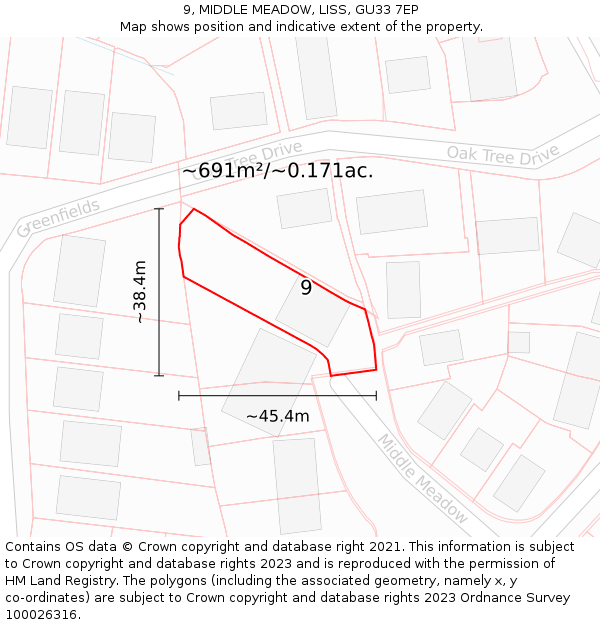
9 MIDDLE MEADOW sits on a plot of roughly 0.171 of an acre, or 691m². The below map shows the location of 9 MIDDLE MEADOW, an approximate outline of the building(s), and the indicative extent of the property. The plot extent is a Land Registry INSPIRE Index Polygon, and it is important to note that a title may include more than one polygon, whereas only one polygon is shown on the map (the polygon which intersects with the position of 9 MIDDLE MEADOW). The full extent of the land contained in any registered title can only be identified from the individual title plan. The maps on this page should not be relied upon to establish the extent of a title.
Where is 9 MIDDLE MEADOW?
9 MIDDLE MEADOW is located in LISS, in the GU33 postcode district. The below map shows the position of No. 9 on MIDDLE MEADOW.

All property sales on MIDDLE MEADOW
Most recent sales first:


- Contains OS data © Crown copyright and database right (2026)
- Contains Royal Mail data © Royal Mail copyright and Database right (2026)
- Contains National Statistics data © Crown copyright and database right (2026)
- Data produced by Land Registry © Crown copyright (2026)
- Contains Environment Agency data licensed under the Open Government Licence v3.0
- Everything else © GetTheData Publishing Limited (2026)
GetTheData.com is owned and operated by GetTheData Publishing Limited.
Company Number: 11075184 · Registered in England and Wales.
Registered Office: 3rd Floor, 86-90 Paul Street, London, England, EC2A 4NE
By accessing our site you agree to us using cookies, and sharing information about your use of our site, in accordance with our privacy policy.