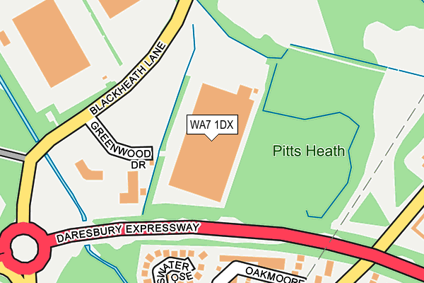
WA7 1DX is located in the Halton Castle electoral ward, within the unitary authority of Halton and the English Parliamentary constituency of Halton. The Sub Integrated Care Board (ICB) Location is NHS Cheshire and Merseyside ICB - 01F and the police force is Cheshire. This postcode has been in use since May 2017.


GetTheData
Source: OS OpenMap – Local (Ordnance Survey)
Source: OS VectorMap District (Ordnance Survey)
Licence: Open Government Licence (requires attribution)
| Easting | 353179 |
| Northing | 383267 |
| Latitude | 53.344230 |
| Longitude | -2.704725 |
GetTheData
Source: Open Postcode Geo
Licence: Open Government Licence
| Country | England |
| Postcode District | WA7 |
| ➜ WA7 open data dashboard ➜ See where WA7 is on a map ➜ Where is Runcorn? | |
GetTheData
Source: Land Registry Price Paid Data
Licence: Open Government Licence
| Ward | Halton Castle |
| Constituency | Halton |
GetTheData
Source: ONS Postcode Database
Licence: Open Government Licence
| May 2022 | Anti-social behaviour | On or near Henley Court | 467m |
| April 2022 | Vehicle crime | On or near Bridgewater Interchange | 349m |
| April 2022 | Other theft | On or near Henley Court | 467m |
| ➜ Get more crime data in our Crime section | |||
GetTheData
Source: data.police.uk
Licence: Open Government Licence
| Davy Road (Busway (Astmoor)) | Astmoor | 180m |
| Davy Road (Busway (Astmoor)) | Astmoor | 193m |
| Chadwick Road (Buusway (Astmoor)) | Astmoor | 210m |
| Chadwick Road (Busway (Astmoor)) | Astmoor | 219m |
| Brindley Road (Busway (Astmoor)) | Astmoor | 411m |
| Runcorn Station | 2.4km |
| Runcorn East Station | 3.2km |
| Widnes Station | 4.3km |
GetTheData
Source: NaPTAN
Licence: Open Government Licence
GetTheData
Source: ONS Postcode Database
Licence: Open Government Licence


➜ Get more ratings from the Food Standards Agency
GetTheData
Source: Food Standards Agency
Licence: FSA terms & conditions
| Last Collection | |||
|---|---|---|---|
| Location | Mon-Fri | Sat | Distance |
| Astmoor Ind Estate | 18:15 | 12:00 | 657m |
| Halton Road | 17:30 | 11:00 | 721m |
| Halton Road | 17:30 | 11:30 | 899m |
GetTheData
Source: Dracos
Licence: Creative Commons Attribution-ShareAlike
| Facility | Distance |
|---|---|
| The Brow Community Primary School The Clough, Halton, Runcorn Grass Pitches | 1.1km |
| Runcorn Boys Club Boston Avenue, Runcorn Grass Pitches | 1.1km |
| Grange Comprehensive School (Closed) Latham Avenue, Runcorn Health and Fitness Gym, Grass Pitches, Sports Hall, Studio, Outdoor Tennis Courts | 1.3km |
GetTheData
Source: Active Places
Licence: Open Government Licence
| School | Phase of Education | Distance |
|---|---|---|
| The Bridge School Chadwick Road, Astmoor, Runcorn, WA7 1PW | Not applicable | 452m |
| Astmoor Primary School Kingshead Close, Castlefields, Runcorn, WA7 2JE | Primary | 974m |
| St Augustine's Catholic Primary School, A Voluntary Academy Conwy Court, Castlefields, Runcorn, WA7 2JJ | Primary | 1.1km |
GetTheData
Source: Edubase
Licence: Open Government Licence
| Risk of WA7 1DX flooding from rivers and sea | Medium |
| ➜ WA7 1DX flood map | |
GetTheData
Source: Open Flood Risk by Postcode
Licence: Open Government Licence
The below table lists the International Territorial Level (ITL) codes (formerly Nomenclature of Territorial Units for Statistics (NUTS) codes) and Local Administrative Units (LAU) codes for WA7 1DX:
| ITL 1 Code | Name |
|---|---|
| TLD | North West (England) |
| ITL 2 Code | Name |
| TLD7 | Merseyside |
| ITL 3 Code | Name |
| TLD71 | East Merseyside |
| LAU 1 Code | Name |
| E06000006 | Halton |
GetTheData
Source: ONS Postcode Directory
Licence: Open Government Licence
The below table lists the Census Output Area (OA), Lower Layer Super Output Area (LSOA), and Middle Layer Super Output Area (MSOA) for WA7 1DX:
| Code | Name | |
|---|---|---|
| OA | E00170540 | |
| LSOA | E01012382 | Halton 010B |
| MSOA | E02002583 | Halton 010 |
GetTheData
Source: ONS Postcode Directory
Licence: Open Government Licence
| WA7 1QF | Goddard Road | 95m |
| WA7 1PU | Dalton Court | 137m |
| WA7 1PZ | Davy Road | 225m |
| WA7 5RE | Brookfield Avenue | 412m |
| WA7 5QZ | Brookfield Avenue | 471m |
| WA7 5QL | Henley Court | 473m |
| WA7 5RB | Kingston Close | 492m |
| WA7 5NF | Sea Lane | 494m |
| WA7 5NN | Fairfax Drive | 509m |
| WA7 5QY | Renton Avenue | 518m |
GetTheData
Source: Open Postcode Geo; Land Registry Price Paid Data
Licence: Open Government Licence