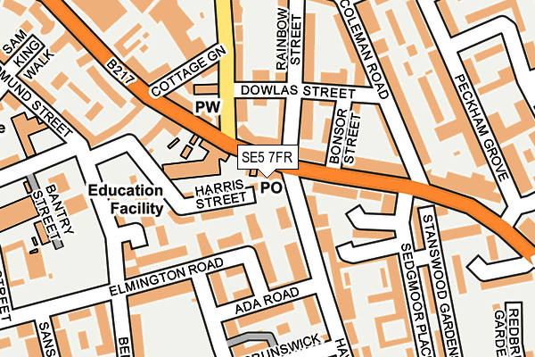
SE5 7FR is located in the St Giles electoral ward, within the London borough of Southwark and the English Parliamentary constituency of Camberwell and Peckham. The Sub Integrated Care Board (ICB) Location is NHS South East London ICB - 72Q and the police force is Metropolitan Police. This postcode has been in use since April 2017.


GetTheData
Source: OS OpenMap – Local (Ordnance Survey)
Source: OS VectorMap District (Ordnance Survey)
Licence: Open Government Licence (requires attribution)
| Easting | 533108 |
| Northing | 177191 |
| Latitude | 51.478026 |
| Longitude | -0.084633 |
GetTheData
Source: Open Postcode Geo
Licence: Open Government Licence
| Country | England |
| Postcode District | SE5 |
| ➜ SE5 open data dashboard ➜ See where SE5 is on a map ➜ Where is Camberwell? | |
GetTheData
Source: Land Registry Price Paid Data
Licence: Open Government Licence
| Ward | St Giles |
| Constituency | Camberwell And Peckham |
GetTheData
Source: ONS Postcode Database
Licence: Open Government Licence
| January 2024 | Burglary | On or near Savannah Close | 434m |
| January 2024 | Vehicle crime | On or near Savannah Close | 434m |
| December 2023 | Other theft | On or near Mary Datchelor Close | 432m |
| ➜ Get more crime data in our Crime section | |||
GetTheData
Source: data.police.uk
Licence: Open Government Licence
| Sedgmoor Place (Southampton Way) | Camberwell | 127m |
| Cottage Green (Wells Way) | Camberwell | 175m |
| Sedgmoor Place | Camberwell | 177m |
| St George's Way Burgess Park (Wells Way) | Camberwell | 322m |
| Southampton Way Estate (Southampton Way) | Peckham | 337m |
| Denmark Hill Station | 1.1km |
| Peckham Rye Station | 1.4km |
| Loughborough Junction Station | 1.8km |
GetTheData
Source: NaPTAN
Licence: Open Government Licence
➜ Broadband speed and availability dashboard for SE5 7FR
| Percentage of properties with Next Generation Access | 100.0% |
| Percentage of properties with Superfast Broadband | 100.0% |
| Percentage of properties with Ultrafast Broadband | 0.0% |
| Percentage of properties with Full Fibre Broadband | 0.0% |
Superfast Broadband is between 30Mbps and 300Mbps
Ultrafast Broadband is > 300Mbps
| Median download speed | 69.3Mbps |
| Average download speed | 56.9Mbps |
| Maximum download speed | 80.00Mbps |
| Median upload speed | 19.7Mbps |
| Average upload speed | 14.3Mbps |
| Maximum upload speed | 20.00Mbps |
| Percentage of properties unable to receive 2Mbps | 0.0% |
| Percentage of properties unable to receive 5Mbps | 0.0% |
| Percentage of properties unable to receive 10Mbps | 0.0% |
| Percentage of properties unable to receive 30Mbps | 0.0% |
➜ Broadband speed and availability dashboard for SE5 7FR
GetTheData
Source: Ofcom
Licence: Ofcom Terms of Use (requires attribution)
GetTheData
Source: ONS Postcode Database
Licence: Open Government Licence


➜ Get more ratings from the Food Standards Agency
GetTheData
Source: Food Standards Agency
Licence: FSA terms & conditions
| Last Collection | |||
|---|---|---|---|
| Location | Mon-Fri | Sat | Distance |
| Post Office | 17:30 | 12:00 | 34m |
| Southampton Way | 17:30 | 12:00 | 311m |
| Elmington Road | 17:30 | 12:00 | 335m |
GetTheData
Source: Dracos
Licence: Creative Commons Attribution-ShareAlike
| Facility | Distance |
|---|---|
| Puregym (London Camberwell Southampton Way) Southampton Way, Southampton Way, London Health and Fitness Gym | 214m |
| Brunswick Park Primary School Picton Street, London Sports Hall | 295m |
| Brunswick Park (Southwark) St. Giles Road, London Outdoor Tennis Courts | 317m |
GetTheData
Source: Active Places
Licence: Open Government Licence
| School | Phase of Education | Distance |
|---|---|---|
| Spa School Camberwell 150 Southampton Way, London, SE5 7EW | Not applicable | 90m |
| St George's Church of England Primary School Coleman Road, Camberwell, London, SE5 7TF | Primary | 264m |
| Brunswick Park Primary School Picton Street, Camberwell, London, SE5 7QH | Primary | 288m |
GetTheData
Source: Edubase
Licence: Open Government Licence
| Risk of SE5 7FR flooding from rivers and sea | Very Low |
| ➜ SE5 7FR flood map | |
GetTheData
Source: Open Flood Risk by Postcode
Licence: Open Government Licence
The below table lists the International Territorial Level (ITL) codes (formerly Nomenclature of Territorial Units for Statistics (NUTS) codes) and Local Administrative Units (LAU) codes for SE5 7FR:
| ITL 1 Code | Name |
|---|---|
| TLI | London |
| ITL 2 Code | Name |
| TLI4 | Inner London - East |
| ITL 3 Code | Name |
| TLI44 | Lewisham and Southwark |
| LAU 1 Code | Name |
| E09000028 | Southwark |
GetTheData
Source: ONS Postcode Directory
Licence: Open Government Licence
The below table lists the Census Output Area (OA), Lower Layer Super Output Area (LSOA), and Middle Layer Super Output Area (MSOA) for SE5 7FR:
| Code | Name | |
|---|---|---|
| OA | E00019707 | |
| LSOA | E01003917 | Southwark 020C |
| MSOA | E02000826 | Southwark 020 |
GetTheData
Source: ONS Postcode Directory
Licence: Open Government Licence
| SE5 7EW | Southampton Way | 35m |
| SE5 7SL | Stacy Path | 62m |
| SE5 7SA | Harris Street | 68m |
| SE5 7LS | Havil Street | 72m |
| SE5 7RU | Havil Street | 75m |
| SE5 7EU | Southampton Way | 84m |
| SE5 7QZ | Elmington Road | 98m |
| SE5 7SJ | Ballow Close | 99m |
| SE5 7TE | Bonsor Street | 106m |
| SE5 7TB | Rainbow Street | 120m |
GetTheData
Source: Open Postcode Geo; Land Registry Price Paid Data
Licence: Open Government Licence