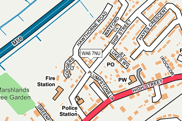
WA6 7NU is located in the Frodsham electoral ward, within the unitary authority of Cheshire West and Chester and the English Parliamentary constituency of Weaver Vale. The Sub Integrated Care Board (ICB) Location is NHS Cheshire and Merseyside ICB - 27D and the police force is Cheshire. This postcode has been in use since May 2017.


GetTheData
Source: OS OpenMap – Local (Ordnance Survey)
Source: OS VectorMap District (Ordnance Survey)
Licence: Open Government Licence (requires attribution)
| Easting | 351823 |
| Northing | 378177 |
| Latitude | 53.298359 |
| Longitude | -2.724315 |
GetTheData
Source: Open Postcode Geo
Licence: Open Government Licence
| Country | England |
| Postcode District | WA6 |
| ➜ WA6 open data dashboard ➜ See where WA6 is on a map ➜ Where is Frodsham? | |
GetTheData
Source: Land Registry Price Paid Data
Licence: Open Government Licence
| Ward | Frodsham |
| Constituency | Weaver Vale |
GetTheData
Source: ONS Postcode Database
Licence: Open Government Licence
| January 2024 | Violence and sexual offences | On or near Parking Area | 287m |
| December 2023 | Public order | On or near Parking Area | 287m |
| December 2023 | Violence and sexual offences | On or near Parking Area | 287m |
| ➜ Get more crime data in our Crime section | |||
GetTheData
Source: data.police.uk
Licence: Open Government Licence
| St Luke's Way (Ship Street) | Frodsham | 71m |
| Devonshire Bakery (High Street) | Frodsham | 206m |
| Co-op (High Street) | Frodsham | 220m |
| St Hilda's Drive (High Street) | Frodsham | 298m |
| Bears Paw (Main Street) | Frodsham | 310m |
| Frodsham Station | 0.3km |
| Helsby Station | 4.1km |
| Runcorn Station | 4.6km |
GetTheData
Source: NaPTAN
Licence: Open Government Licence
| Percentage of properties with Next Generation Access | 100.0% |
| Percentage of properties with Superfast Broadband | 100.0% |
| Percentage of properties with Ultrafast Broadband | 0.0% |
| Percentage of properties with Full Fibre Broadband | 0.0% |
Superfast Broadband is between 30Mbps and 300Mbps
Ultrafast Broadband is > 300Mbps
| Percentage of properties unable to receive 2Mbps | 0.0% |
| Percentage of properties unable to receive 5Mbps | 0.0% |
| Percentage of properties unable to receive 10Mbps | 0.0% |
| Percentage of properties unable to receive 30Mbps | 0.0% |
GetTheData
Source: Ofcom
Licence: Ofcom Terms of Use (requires attribution)
GetTheData
Source: ONS Postcode Database
Licence: Open Government Licence


➜ Get more ratings from the Food Standards Agency
GetTheData
Source: Food Standards Agency
Licence: FSA terms & conditions
| Last Collection | |||
|---|---|---|---|
| Location | Mon-Fri | Sat | Distance |
| Church Street | 17:30 | 10:30 | 337m |
| Frodsham S.o. | 17:30 | 12:30 | 424m |
| Chester Road | 16:00 | 08:30 | 738m |
GetTheData
Source: Dracos
Licence: Creative Commons Attribution-ShareAlike
| Facility | Distance |
|---|---|
| Frodsham Cricket Club Moor Lane, Frodsham Grass Pitches | 330m |
| Frodsham Leisure Centre Princeway, Frodsham Sports Hall, Artificial Grass Pitch, Health and Fitness Gym, Squash Courts, Studio | 519m |
| Castle Park Castle Park, Frodsham Grass Pitches | 771m |
GetTheData
Source: Active Places
Licence: Open Government Licence
| School | Phase of Education | Distance |
|---|---|---|
| St Luke's Catholic Primary School The Willows, Frodsham, WA6 7QP | Primary | 504m |
| Frodsham Primary Academy Ship Street, Frodsham, WA6 7PZ | Primary | 640m |
| Frodsham Manor House Primary School Langdale Way, Frodsham, WA6 7LE | Primary | 683m |
GetTheData
Source: Edubase
Licence: Open Government Licence
The below table lists the International Territorial Level (ITL) codes (formerly Nomenclature of Territorial Units for Statistics (NUTS) codes) and Local Administrative Units (LAU) codes for WA6 7NU:
| ITL 1 Code | Name |
|---|---|
| TLD | North West (England) |
| ITL 2 Code | Name |
| TLD6 | Cheshire |
| ITL 3 Code | Name |
| TLD63 | Cheshire West and Chester |
| LAU 1 Code | Name |
| E06000050 | Cheshire West and Chester |
GetTheData
Source: ONS Postcode Directory
Licence: Open Government Licence
The below table lists the Census Output Area (OA), Lower Layer Super Output Area (LSOA), and Middle Layer Super Output Area (MSOA) for WA6 7NU:
| Code | Name | |
|---|---|---|
| OA | E00094317 | |
| LSOA | E01018689 | Cheshire West and Chester 002E |
| MSOA | E02003874 | Cheshire West and Chester 002 |
GetTheData
Source: ONS Postcode Directory
Licence: Open Government Licence
| WA6 7NZ | Ship Street | 41m |
| WA6 7NP | Hawthorne Road | 52m |
| WA6 7BE | Plumpstons Lane | 62m |
| WA6 7BD | High Street | 67m |
| WA6 7AL | Albert Row | 73m |
| WA6 7NW | Ship Street | 81m |
| WA6 7NN | Rodgers Close | 98m |
| WA6 7NY | St Lukes Way | 103m |
| WA6 7AJ | High Street | 128m |
| WA6 7AN | High Street | 136m |
GetTheData
Source: Open Postcode Geo; Land Registry Price Paid Data
Licence: Open Government Licence