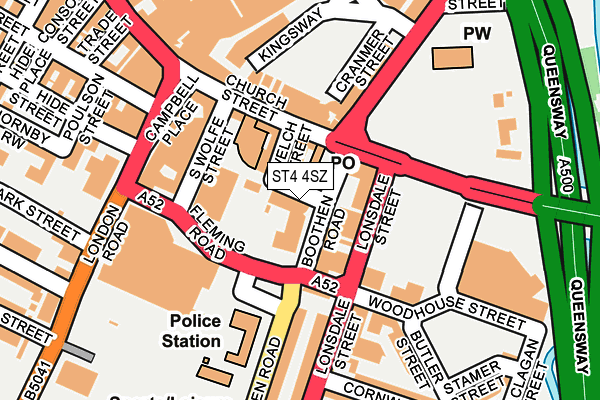
ST4 4SZ is located in the Hartshill Park & Stoke electoral ward, within the unitary authority of Stoke-on-Trent and the English Parliamentary constituency of Stoke-on-Trent Central. The Sub Integrated Care Board (ICB) Location is NHS Staffordshire and Stoke-on-Trent ICB - 05W and the police force is Staffordshire. This postcode has been in use since June 1997.


GetTheData
Source: OS OpenMap – Local (Ordnance Survey)
Source: OS VectorMap District (Ordnance Survey)
Licence: Open Government Licence (requires attribution)
| Easting | 387779 |
| Northing | 345070 |
| Latitude | 53.002806 |
| Longitude | -2.183558 |
GetTheData
Source: Open Postcode Geo
Licence: Open Government Licence
| Country | England |
| Postcode District | ST4 |
| ➜ ST4 open data dashboard ➜ See where ST4 is on a map ➜ Where is Stoke-on-Trent? | |
GetTheData
Source: Land Registry Price Paid Data
Licence: Open Government Licence
Elevation or altitude of ST4 4SZ as distance above sea level:
| Metres | Feet | |
|---|---|---|
| Elevation | 110m | 361ft |
Elevation is measured from the approximate centre of the postcode, to the nearest point on an OS contour line from OS Terrain 50, which has contour spacing of ten vertical metres.
➜ How high above sea level am I? Find the elevation of your current position using your device's GPS.
GetTheData
Source: Open Postcode Elevation
Licence: Open Government Licence
| Ward | Hartshill Park & Stoke |
| Constituency | Stoke-on-trent Central |
GetTheData
Source: ONS Postcode Database
Licence: Open Government Licence
| June 2022 | Other theft | On or near Welch Street | 52m |
| June 2022 | Other theft | On or near Welch Street | 52m |
| June 2022 | Anti-social behaviour | On or near Woodhouse Street | 89m |
| ➜ Get more crime data in our Crime section | |||
GetTheData
Source: data.police.uk
Licence: Open Government Licence
| Stop Q (Church Street) | Stoke-upon-trent | 68m |
| Stop N (Church Street) | Stoke-upon-trent | 86m |
| Stop P (Church Street) | Stoke-upon-trent | 96m |
| Stop O (Church Street) | Stoke-upon-trent | 107m |
| Stop M (Church Street) | Stoke-upon-trent | 141m |
| Stoke-on-Trent Station | 0.6km |
| Longton Station | 3.4km |
| Longport Station | 4.9km |
GetTheData
Source: NaPTAN
Licence: Open Government Licence
Estimated total energy consumption in ST4 4SZ by fuel type, 2015.
| Consumption (kWh) | 88,381 |
|---|---|
| Meter count | 21 |
| Mean (kWh/meter) | 4,209 |
| Median (kWh/meter) | 3,908 |
GetTheData
Source: Postcode level gas estimates: 2015 (experimental)
Source: Postcode level electricity estimates: 2015 (experimental)
Licence: Open Government Licence
GetTheData
Source: ONS Postcode Database
Licence: Open Government Licence


➜ Get more ratings from the Food Standards Agency
GetTheData
Source: Food Standards Agency
Licence: FSA terms & conditions
| Last Collection | |||
|---|---|---|---|
| Location | Mon-Fri | Sat | Distance |
| Stoke Post Office | 18:00 | 12:00 | 57m |
| Glebe Street | 18:30 | 11:45 | 221m |
| Trade Street | 18:30 | 10:00 | 257m |
GetTheData
Source: Dracos
Licence: Creative Commons Attribution-ShareAlike
| Facility | Distance |
|---|---|
| The Training Exchange (Closed) Hill Street, Stoke-on-trent Health and Fitness Gym | 239m |
| Stoke Recreation Centre (Closed) Booth Street, Stoke-on-trent Health and Fitness Gym, Sports Hall, Studio, Squash Courts | 301m |
| Boothen Park Campbell Road, Stoke-on-trent Outdoor Tennis Courts | 807m |
GetTheData
Source: Active Places
Licence: Open Government Licence
| School | Phase of Education | Distance |
|---|---|---|
| Stoke Minster CofE Primary Academy Boothen Old Road, Stoke-on-Trent, ST4 4EE | Primary | 531m |
| City of Stoke-On-Trent Sixth Form College Leek Road, Stoke-on-Trent, ST4 2RU | 16 plus | 535m |
| Staffordshire University College Road, Stoke-on-Trent, ST4 2DE | Not applicable | 743m |
GetTheData
Source: Edubase
Licence: Open Government Licence
| Risk of ST4 4SZ flooding from rivers and sea | Medium |
| ➜ ST4 4SZ flood map | |
GetTheData
Source: Open Flood Risk by Postcode
Licence: Open Government Licence
The below table lists the International Territorial Level (ITL) codes (formerly Nomenclature of Territorial Units for Statistics (NUTS) codes) and Local Administrative Units (LAU) codes for ST4 4SZ:
| ITL 1 Code | Name |
|---|---|
| TLG | West Midlands (England) |
| ITL 2 Code | Name |
| TLG2 | Shropshire and Staffordshire |
| ITL 3 Code | Name |
| TLG23 | Stoke-on-Trent |
| LAU 1 Code | Name |
| E06000021 | Stoke-on-Trent |
GetTheData
Source: ONS Postcode Directory
Licence: Open Government Licence
The below table lists the Census Output Area (OA), Lower Layer Super Output Area (LSOA), and Middle Layer Super Output Area (MSOA) for ST4 4SZ:
| Code | Name | |
|---|---|---|
| OA | E00072416 | |
| LSOA | E01014345 | Stoke-on-Trent 019E |
| MSOA | E02002969 | Stoke-on-Trent 019 |
GetTheData
Source: ONS Postcode Directory
Licence: Open Government Licence
| ST4 4DN | Lonsdale Street | 65m |
| ST4 1DQ | Church Street | 68m |
| ST4 4QX | Woodhouse Street | 101m |
| ST4 1BL | Church Street | 102m |
| ST4 1HP | Glebe Street | 107m |
| ST4 1EH | Woodhouse Street | 135m |
| ST4 1DF | Church Street | 142m |
| ST4 1NA | Campbell Place | 146m |
| ST4 1LX | Campbell Place | 146m |
| ST4 1HL | Glebe Street | 150m |
GetTheData
Source: Open Postcode Geo; Land Registry Price Paid Data
Licence: Open Government Licence