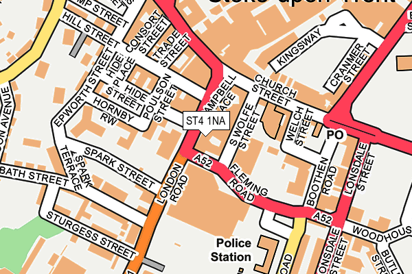
ST4 1NA lies on Campbell Place in Stoke-on-trent. ST4 1NA is located in the Hartshill Park & Stoke electoral ward, within the unitary authority of Stoke-on-Trent and the English Parliamentary constituency of Stoke-on-Trent Central. The Sub Integrated Care Board (ICB) Location is NHS Staffordshire and Stoke-on-Trent ICB - 05W and the police force is Staffordshire. This postcode has been in use since January 1980.


GetTheData
Source: OS OpenMap – Local (Ordnance Survey)
Source: OS VectorMap District (Ordnance Survey)
Licence: Open Government Licence (requires attribution)
| Easting | 387644 |
| Northing | 345126 |
| Latitude | 53.003323 |
| Longitude | -2.185572 |
GetTheData
Source: Open Postcode Geo
Licence: Open Government Licence
| Street | Campbell Place |
| Town/City | Stoke-on-trent |
| Country | England |
| Postcode District | ST4 |
| ➜ ST4 open data dashboard ➜ See where ST4 is on a map ➜ Where is Stoke-on-Trent? | |
GetTheData
Source: Land Registry Price Paid Data
Licence: Open Government Licence
Elevation or altitude of ST4 1NA as distance above sea level:
| Metres | Feet | |
|---|---|---|
| Elevation | 120m | 394ft |
Elevation is measured from the approximate centre of the postcode, to the nearest point on an OS contour line from OS Terrain 50, which has contour spacing of ten vertical metres.
➜ How high above sea level am I? Find the elevation of your current position using your device's GPS.
GetTheData
Source: Open Postcode Elevation
Licence: Open Government Licence
| Ward | Hartshill Park & Stoke |
| Constituency | Stoke-on-trent Central |
GetTheData
Source: ONS Postcode Database
Licence: Open Government Licence
MAJESTIC CHAMBERS, 24, CAMPBELL PLACE, STOKE-ON-TRENT, ST4 1NA 1999 5 AUG £585,000 |
GetTheData
Source: HM Land Registry Price Paid Data
Licence: Contains HM Land Registry data © Crown copyright and database right 2024. This data is licensed under the Open Government Licence v3.0.
| January 2024 | Criminal damage and arson | On or near Charlton Street | 461m |
| January 2024 | Violence and sexual offences | On or near Charlton Street | 461m |
| December 2023 | Violence and sexual offences | On or near Charlton Street | 461m |
| ➜ Get more crime data in our Crime section | |||
GetTheData
Source: data.police.uk
Licence: Open Government Licence
| Stop T (Campbell Place) | Stoke-upon-trent | 28m |
| Stop M (Church Street) | Stoke-upon-trent | 79m |
| Stop O (Church Street) | Stoke-upon-trent | 86m |
| Stop R (London Road) | Stoke-upon-trent | 91m |
| Stop P (Church Street) | Stoke-upon-trent | 98m |
| Stoke-on-Trent Station | 0.6km |
| Longton Station | 3.6km |
| Longport Station | 4.8km |
GetTheData
Source: NaPTAN
Licence: Open Government Licence
GetTheData
Source: ONS Postcode Database
Licence: Open Government Licence


➜ Get more ratings from the Food Standards Agency
GetTheData
Source: Food Standards Agency
Licence: FSA terms & conditions
| Last Collection | |||
|---|---|---|---|
| Location | Mon-Fri | Sat | Distance |
| Stoke Post Office | 18:00 | 12:00 | 131m |
| Trade Street | 18:30 | 10:00 | 132m |
| Glebe Street | 18:30 | 11:45 | 284m |
GetTheData
Source: Dracos
Licence: Creative Commons Attribution-ShareAlike
| Facility | Distance |
|---|---|
| The Training Exchange (Closed) Hill Street, Stoke-on-trent Health and Fitness Gym | 102m |
| Stoke Recreation Centre (Closed) Booth Street, Stoke-on-trent Health and Fitness Gym, Sports Hall, Studio, Squash Courts | 339m |
| The Willows Primary School Greatbatch Avenue, Greatbatch Avenue, Stoke-on-trent Grass Pitches | 743m |
GetTheData
Source: Active Places
Licence: Open Government Licence
| School | Phase of Education | Distance |
|---|---|---|
| City of Stoke-On-Trent Sixth Form College Leek Road, Stoke-on-Trent, ST4 2RU | 16 plus | 604m |
| Stoke Minster CofE Primary Academy Boothen Old Road, Stoke-on-Trent, ST4 4EE | Primary | 616m |
| The Willows Primary School Greatbatch Avenue, Penkhull, Stoke-on-Trent, ST4 7JY | Primary | 729m |
GetTheData
Source: Edubase
Licence: Open Government Licence
The below table lists the International Territorial Level (ITL) codes (formerly Nomenclature of Territorial Units for Statistics (NUTS) codes) and Local Administrative Units (LAU) codes for ST4 1NA:
| ITL 1 Code | Name |
|---|---|
| TLG | West Midlands (England) |
| ITL 2 Code | Name |
| TLG2 | Shropshire and Staffordshire |
| ITL 3 Code | Name |
| TLG23 | Stoke-on-Trent |
| LAU 1 Code | Name |
| E06000021 | Stoke-on-Trent |
GetTheData
Source: ONS Postcode Directory
Licence: Open Government Licence
The below table lists the Census Output Area (OA), Lower Layer Super Output Area (LSOA), and Middle Layer Super Output Area (MSOA) for ST4 1NA:
| Code | Name | |
|---|---|---|
| OA | E00072417 | |
| LSOA | E01014345 | Stoke-on-Trent 019E |
| MSOA | E02002969 | Stoke-on-Trent 019 |
GetTheData
Source: ONS Postcode Directory
Licence: Open Government Licence
| ST4 1LX | Campbell Place | 39m |
| ST4 1NH | Campbell Place | 40m |
| ST4 1DF | Church Street | 56m |
| ST4 1NF | Hide Street | 85m |
| ST4 1DE | Church Street | 95m |
| ST4 1DQ | Church Street | 109m |
| ST4 1BU | Church Street | 120m |
| ST4 1BL | Church Street | 130m |
| ST4 1NL | Hill Street | 137m |
| ST4 1JH | Kingsway | 138m |
GetTheData
Source: Open Postcode Geo; Land Registry Price Paid Data
Licence: Open Government Licence