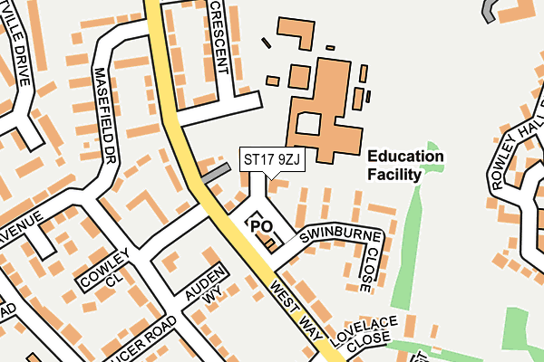
ST17 9ZJ is located in the Highfields & Western Downs electoral ward, within the local authority district of Stafford and the English Parliamentary constituency of Stafford. The Sub Integrated Care Board (ICB) Location is NHS Staffordshire and Stoke-on-Trent ICB - 05V and the police force is Staffordshire. This postcode has been in use since April 2017.


GetTheData
Source: OS OpenMap – Local (Ordnance Survey)
Source: OS VectorMap District (Ordnance Survey)
Licence: Open Government Licence (requires attribution)
| Easting | 391214 |
| Northing | 321962 |
| Latitude | 52.795165 |
| Longitude | -2.131736 |
GetTheData
Source: Open Postcode Geo
Licence: Open Government Licence
| Country | England |
| Postcode District | ST17 |
| ➜ ST17 open data dashboard ➜ See where ST17 is on a map ➜ Where is Stafford? | |
GetTheData
Source: Land Registry Price Paid Data
Licence: Open Government Licence
| Ward | Highfields & Western Downs |
| Constituency | Stafford |
GetTheData
Source: ONS Postcode Database
Licence: Open Government Licence
| March 2023 | Violence and sexual offences | On or near Pantulf Close | 351m |
| June 2022 | Violence and sexual offences | On or near Swinburne Close | 72m |
| June 2022 | Criminal damage and arson | On or near Swinburne Close | 72m |
| ➜ Get more crime data in our Crime section | |||
GetTheData
Source: data.police.uk
Licence: Open Government Licence
| Dryden Crescent (West Way) | Highfields | 103m |
| Cowley Close (Shakespeare Road) | Highfields | 125m |
| Cowley Close (Wordsworth Avenue) | Highfields | 163m |
| Masefield Drive (West Way) | Highfields | 187m |
| Lovelace Close (West Way) | Highfields | 219m |
| Stafford Station | 1.2km |
GetTheData
Source: NaPTAN
Licence: Open Government Licence
| Percentage of properties with Next Generation Access | 100.0% |
| Percentage of properties with Superfast Broadband | 100.0% |
| Percentage of properties with Ultrafast Broadband | 0.0% |
| Percentage of properties with Full Fibre Broadband | 0.0% |
Superfast Broadband is between 30Mbps and 300Mbps
Ultrafast Broadband is > 300Mbps
| Percentage of properties unable to receive 2Mbps | 0.0% |
| Percentage of properties unable to receive 5Mbps | 0.0% |
| Percentage of properties unable to receive 10Mbps | 0.0% |
| Percentage of properties unable to receive 30Mbps | 0.0% |
GetTheData
Source: Ofcom
Licence: Ofcom Terms of Use (requires attribution)
GetTheData
Source: ONS Postcode Database
Licence: Open Government Licence


➜ Get more ratings from the Food Standards Agency
GetTheData
Source: Food Standards Agency
Licence: FSA terms & conditions
| Last Collection | |||
|---|---|---|---|
| Location | Mon-Fri | Sat | Distance |
| Border Way | 17:45 | 10:45 | 580m |
| Castle Bank | 17:30 | 10:45 | 787m |
| St Johns Road | 17:20 | 09:30 | 885m |
GetTheData
Source: Dracos
Licence: Creative Commons Attribution-ShareAlike
| Facility | Distance |
|---|---|
| King Edward Vi High School Dryden Crescent, Stafford Grass Pitches, Sports Hall, Outdoor Tennis Courts | 104m |
| Castlechurch Primary School Tennyson Road, Stafford Sports Hall, Artificial Grass Pitch | 327m |
| Rowley Park Sport Stadium Averill Road, Stafford Athletics, Grass Pitches, Outdoor Tennis Courts, Artificial Grass Pitch | 509m |
GetTheData
Source: Active Places
Licence: Open Government Licence
| School | Phase of Education | Distance |
|---|---|---|
| King Edward VI High School Westway, Stafford, ST17 9YJ | Secondary | 104m |
| Castlechurch Primary School Tennyson Road, Stafford, ST17 9SY | Primary | 326m |
| Blessed Mother Teresa's Catholic Primary School Somerset Road, Highfields, Stafford, ST17 9UZ | Primary | 501m |
GetTheData
Source: Edubase
Licence: Open Government Licence
The below table lists the International Territorial Level (ITL) codes (formerly Nomenclature of Territorial Units for Statistics (NUTS) codes) and Local Administrative Units (LAU) codes for ST17 9ZJ:
| ITL 1 Code | Name |
|---|---|
| TLG | West Midlands (England) |
| ITL 2 Code | Name |
| TLG2 | Shropshire and Staffordshire |
| ITL 3 Code | Name |
| TLG24 | Staffordshire CC |
| LAU 1 Code | Name |
| E07000197 | Stafford |
GetTheData
Source: ONS Postcode Directory
Licence: Open Government Licence
The below table lists the Census Output Area (OA), Lower Layer Super Output Area (LSOA), and Middle Layer Super Output Area (MSOA) for ST17 9ZJ:
| Code | Name | |
|---|---|---|
| OA | E00151517 | |
| LSOA | E01029737 | Stafford 012C |
| MSOA | E02006199 | Stafford 012 |
GetTheData
Source: ONS Postcode Directory
Licence: Open Government Licence
| ST17 9YF | West Way | 55m |
| ST17 9YE | Swinburne Close | 101m |
| ST17 9UX | West Way | 124m |
| ST17 9UU | West Way | 127m |
| ST17 9TX | Auden Way | 134m |
| ST17 9UP | West Way Green | 141m |
| ST17 9YD | West Way | 144m |
| ST17 9YH | Dryden Crescent | 181m |
| ST17 9YG | West Way | 182m |
| ST17 9YB | Lovelace Close | 185m |
GetTheData
Source: Open Postcode Geo; Land Registry Price Paid Data
Licence: Open Government Licence