RG8 6EH maps, stats, and open data
RG8 6EH is located in the Pangbourne electoral ward, within the unitary authority of West Berkshire and the English Parliamentary constituency of Reading West. The Sub Integrated Care Board (ICB) Location is NHS Buckinghamshire, Oxfordshire and Berkshire West ICB - 15A and the police force is Thames Valley. This postcode has been in use since August 2021.
RG8 6EH geodata
| Easting | 463471 |
| Northing | 176456 |
| Latitude | 51.483507 |
| Longitude | -1.087319 |
Where is RG8 6EH?
| Country | England |
| Postcode District | RG8 |
Politics
| Ward | Pangbourne |
|---|
| Constituency | Reading West |
|---|
Transport
Nearest bus stops to RG8 6EH
| Old Post Office (A340 Church Road) | Pangbourne | 21m |
| Pangbourne Village Hall (A329 Church Road) | Pangbourne | 86m |
| The George Hotel (A329 The Square) | Pangbourne | 95m |
| The George Hotel (B471 Whitchurch Road) | Pangbourne | 126m |
| Police Station (A329 Reading Road) | Pangbourne | 254m |
Nearest railway stations to RG8 6EH
| Pangbourne Station | 0.3km |
| Tilehurst Station | 4.2km |
| Goring & Streatley Station | 5.3km |
Deprivation
10.8% of English postcodes are less deprived than
RG8 6EH:
Food Standards Agency
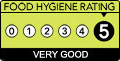
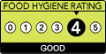
Three nearest food hygiene ratings to RG8 6EH (metres)
Ministry Of Drinks
Simply Wines Direct
Cross Keys
Cross Keys Church Road
26m
➜ Get more ratings from the Food Standards Agency
Nearest post box to RG8 6EH
| | Last Collection | |
|---|
| Location | Mon-Fri | Sat | Distance |
|---|
| Railway Station | 17:00 | 11:45 | 323m |
| Path Hill | 16:30 | 07:00 | 2,627m |
| Upper Basildon | 16:15 | 09:00 | 2,778m |
RG8 6EH ITL and RG8 6EH LAU
The below table lists the International Territorial Level (ITL) codes (formerly Nomenclature of Territorial Units for Statistics (NUTS) codes) and Local Administrative Units (LAU) codes for RG8 6EH:
| ITL 1 Code | Name |
|---|
| TLJ | South East (England) |
| ITL 2 Code | Name |
|---|
| TLJ1 | Berkshire, Buckinghamshire and Oxfordshire |
| ITL 3 Code | Name |
|---|
| TLJ11 | Berkshire |
| LAU 1 Code | Name |
|---|
| E06000037 | West Berkshire |
RG8 6EH census areas
The below table lists the Census Output Area (OA), Lower Layer Super Output Area (LSOA), and Middle Layer Super Output Area (MSOA) for RG8 6EH:
| Code | Name |
|---|
| OA | E00082412 | |
|---|
| LSOA | E01016314 | West Berkshire 003D |
|---|
| MSOA | E02003369 | West Berkshire 003 |
|---|
Nearest postcodes to RG8 6EH