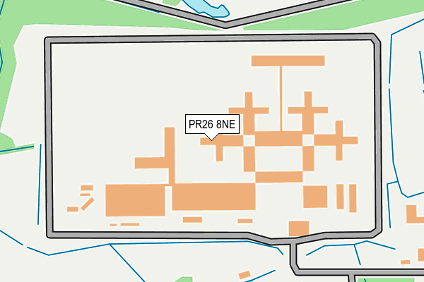
PR26 8NE is located in the Croston, Mawdesley & Euxton South electoral ward, within the local authority district of Chorley and the English Parliamentary constituency of South Ribble. The Sub Integrated Care Board (ICB) Location is NHS Lancashire and South Cumbria ICB - 00X and the police force is Lancashire. This postcode has been in use since June 2001.


GetTheData
Source: OS OpenMap – Local (Ordnance Survey)
Source: OS VectorMap District (Ordnance Survey)
Licence: Open Government Licence (requires attribution)
| Easting | 350024 |
| Northing | 420732 |
| Latitude | 53.680646 |
| Longitude | -2.758097 |
GetTheData
Source: Open Postcode Geo
Licence: Open Government Licence
| Country | England |
| Postcode District | PR26 |
| ➜ PR26 open data dashboard ➜ See where PR26 is on a map ➜ Where is Wymott? | |
GetTheData
Source: Land Registry Price Paid Data
Licence: Open Government Licence
Elevation or altitude of PR26 8NE as distance above sea level:
| Metres | Feet | |
|---|---|---|
| Elevation | 10m | 33ft |
Elevation is measured from the approximate centre of the postcode, to the nearest point on an OS contour line from OS Terrain 50, which has contour spacing of ten vertical metres.
➜ How high above sea level am I? Find the elevation of your current position using your device's GPS.
GetTheData
Source: Open Postcode Elevation
Licence: Open Government Licence
| Ward | Croston, Mawdesley & Euxton South |
| Constituency | South Ribble |
GetTheData
Source: ONS Postcode Database
Licence: Open Government Licence
| June 2022 | Other crime | On or near Prison | 166m |
| June 2022 | Other crime | On or near Prison | 166m |
| June 2022 | Drugs | On or near Prison | 166m |
| ➜ Get more crime data in our Crime section | |||
GetTheData
Source: data.police.uk
Licence: Open Government Licence
| H M Prison Garth (Willow Road) | Wymott | 296m |
| H M Prison (Willow Road) | Wymott | 407m |
| Willow Road (Ulnes Walton Lane) | Wymott | 707m |
| Wray Crescent | Wymott | 825m |
| Moss Lane | Wymott | 915m |
| Croston Station | 2km |
| Leyland Station | 5.1km |
| Lostock Hall Station | 6.7km |
GetTheData
Source: NaPTAN
Licence: Open Government Licence
GetTheData
Source: ONS Postcode Database
Licence: Open Government Licence


➜ Get more ratings from the Food Standards Agency
GetTheData
Source: Food Standards Agency
Licence: FSA terms & conditions
| Last Collection | |||
|---|---|---|---|
| Location | Mon-Fri | Sat | Distance |
| Old Bretherton Post Office | 16:45 | 11:00 | 2,034m |
| Springfield Road | 17:15 | 11:30 | 2,799m |
| Lydiate Lane, Eccleston | 16:15 | 11:15 | 2,825m |
GetTheData
Source: Dracos
Licence: Creative Commons Attribution-ShareAlike
| Facility | Distance |
|---|---|
| Hmp Garth Ulnes Walton Lane, Leyland Grass Pitches | 0m |
| Hmp Wymott Ulnes Walton Lane, Leyland Grass Pitches | 627m |
| Bretherton Cricket Club South Road, Bretherton, Leyland Grass Pitches | 1.8km |
GetTheData
Source: Active Places
Licence: Open Government Licence
| School | Phase of Education | Distance |
|---|---|---|
| Aurora Brooklands School 159 Longmeanygate, Midge Hall, Leyland, PR26 7TB | Not applicable | 2.1km |
| Leyland St James Church of England Primary School Slater Lane, Leyland, PR26 7SH | Primary | 2.1km |
| Bishop Rawstorne Church of England Academy Highfield Road, Croston, Leyland, PR26 9HH | Secondary | 2.2km |
GetTheData
Source: Edubase
Licence: Open Government Licence
| Risk of PR26 8NE flooding from rivers and sea | Medium |
| ➜ PR26 8NE flood map | |
GetTheData
Source: Open Flood Risk by Postcode
Licence: Open Government Licence
The below table lists the International Territorial Level (ITL) codes (formerly Nomenclature of Territorial Units for Statistics (NUTS) codes) and Local Administrative Units (LAU) codes for PR26 8NE:
| ITL 1 Code | Name |
|---|---|
| TLD | North West (England) |
| ITL 2 Code | Name |
| TLD4 | Lancashire |
| ITL 3 Code | Name |
| TLD47 | Chorley and West Lancashire |
| LAU 1 Code | Name |
| E07000118 | Chorley |
GetTheData
Source: ONS Postcode Directory
Licence: Open Government Licence
The below table lists the Census Output Area (OA), Lower Layer Super Output Area (LSOA), and Middle Layer Super Output Area (MSOA) for PR26 8NE:
| Code | Name | |
|---|---|---|
| OA | E00170510 | |
| LSOA | E01024975 | Chorley 007C |
| MSOA | E02005195 | Chorley 007 |
GetTheData
Source: ONS Postcode Directory
Licence: Open Government Licence
| PR26 8NH | Wray Crescent | 784m |
| PR26 9AZ | Cocker Bar Road | 804m |
| PR26 8NJ | Cutt Close | 811m |
| PR26 8NP | Willow Road | 829m |
| PR26 8LX | Moss Lane | 854m |
| PR26 8NR | The Maples | 881m |
| PR26 8NL | Glover Close | 890m |
| PR26 8NN | The Causeway | 935m |
| PR26 8NW | Wade Brook Road | 993m |
| PR26 8LT | Ulnes Walton Lane | 1223m |
GetTheData
Source: Open Postcode Geo; Land Registry Price Paid Data
Licence: Open Government Licence