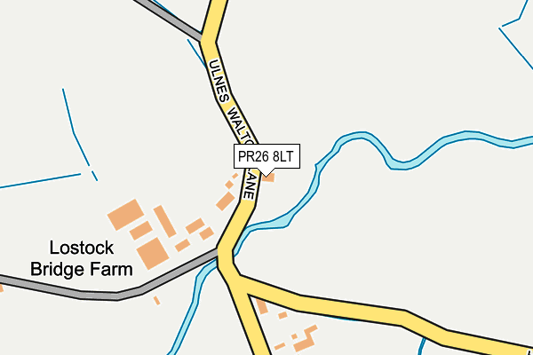
PR26 8LT lies on Ulnes Walton Lane in Leyland. PR26 8LT is located in the Croston, Mawdesley & Euxton South electoral ward, within the local authority district of Chorley and the English Parliamentary constituency of South Ribble. The Sub Integrated Care Board (ICB) Location is NHS Lancashire and South Cumbria ICB - 00X and the police force is Lancashire. This postcode has been in use since June 2001.


GetTheData
Source: OS OpenMap – Local (Ordnance Survey)
Source: OS VectorMap District (Ordnance Survey)
Licence: Open Government Licence (requires attribution)
| Easting | 350883 |
| Northing | 419862 |
| Latitude | 53.672908 |
| Longitude | -2.744955 |
GetTheData
Source: Open Postcode Geo
Licence: Open Government Licence
| Street | Ulnes Walton Lane |
| Town/City | Leyland |
| Country | England |
| Postcode District | PR26 |
➜ See where PR26 is on a map | |
GetTheData
Source: Land Registry Price Paid Data
Licence: Open Government Licence
Elevation or altitude of PR26 8LT as distance above sea level:
| Metres | Feet | |
|---|---|---|
| Elevation | 10m | 33ft |
Elevation is measured from the approximate centre of the postcode, to the nearest point on an OS contour line from OS Terrain 50, which has contour spacing of ten vertical metres.
➜ How high above sea level am I? Find the elevation of your current position using your device's GPS.
GetTheData
Source: Open Postcode Elevation
Licence: Open Government Licence
| Ward | Croston, Mawdesley & Euxton South |
| Constituency | South Ribble |
GetTheData
Source: ONS Postcode Database
Licence: Open Government Licence
| Bullen's Farm (Ulnes Walton Lane) | Wymott | 276m |
| Bullen's Farm (Ulnes Walton Lane) | Wymott | 277m |
| Moss Lane (Ulnes Walton Lane) | Wymott | 383m |
| Equestrian Centre (Ulnes Walton Lane) | Ulnes Walton | 439m |
| Moss Lane | Wymott | 439m |
| Croston Station | 2.2km |
| Leyland Station | 4.8km |
| Euxton Balshaw Lane Station | 5km |
GetTheData
Source: NaPTAN
Licence: Open Government Licence
| Percentage of properties with Next Generation Access | 100.0% |
| Percentage of properties with Superfast Broadband | 92.9% |
| Percentage of properties with Ultrafast Broadband | 53.6% |
| Percentage of properties with Full Fibre Broadband | 53.6% |
Superfast Broadband is between 30Mbps and 300Mbps
Ultrafast Broadband is > 300Mbps
| Median download speed | 18.9Mbps |
| Average download speed | 24.9Mbps |
| Maximum download speed | 65.47Mbps |
| Median upload speed | 2.3Mbps |
| Average upload speed | 3.7Mbps |
| Maximum upload speed | 10.00Mbps |
| Percentage of properties unable to receive 2Mbps | 0.0% |
| Percentage of properties unable to receive 5Mbps | 3.6% |
| Percentage of properties unable to receive 10Mbps | 3.6% |
| Percentage of properties unable to receive 30Mbps | 7.1% |
GetTheData
Source: Ofcom
Licence: Ofcom Terms of Use (requires attribution)
Estimated total energy consumption in PR26 8LT by fuel type, 2015.
| Consumption (kWh) | 111,991 |
|---|---|
| Meter count | 15 |
| Mean (kWh/meter) | 7,466 |
| Median (kWh/meter) | 8,342 |
GetTheData
Source: Postcode level gas estimates: 2015 (experimental)
Source: Postcode level electricity estimates: 2015 (experimental)
Licence: Open Government Licence
GetTheData
Source: ONS Postcode Database
Licence: Open Government Licence


➜ Get more ratings from the Food Standards Agency
GetTheData
Source: Food Standards Agency
Licence: FSA terms & conditions
| Last Collection | |||
|---|---|---|---|
| Location | Mon-Fri | Sat | Distance |
| Lydiate Lane, Eccleston | 16:15 | 11:15 | 1,610m |
| Springfield Road | 17:15 | 11:30 | 2,328m |
| Wade Hall | 17:15 | 11:30 | 2,519m |
GetTheData
Source: Dracos
Licence: Creative Commons Attribution-ShareAlike
The below table lists the International Territorial Level (ITL) codes (formerly Nomenclature of Territorial Units for Statistics (NUTS) codes) and Local Administrative Units (LAU) codes for PR26 8LT:
| ITL 1 Code | Name |
|---|---|
| TLD | North West (England) |
| ITL 2 Code | Name |
| TLD4 | Lancashire |
| ITL 3 Code | Name |
| TLD47 | Chorley and West Lancashire |
| LAU 1 Code | Name |
| E07000118 | Chorley |
GetTheData
Source: ONS Postcode Directory
Licence: Open Government Licence
The below table lists the Census Output Area (OA), Lower Layer Super Output Area (LSOA), and Middle Layer Super Output Area (MSOA) for PR26 8LT:
| Code | Name | |
|---|---|---|
| OA | E00126769 | |
| LSOA | E01024975 | Chorley 007C |
| MSOA | E02005195 | Chorley 007 |
GetTheData
Source: ONS Postcode Directory
Licence: Open Government Licence
| PR26 8LX | Moss Lane | 730m |
| PR26 8NR | The Maples | 863m |
| PR26 8NP | Willow Road | 901m |
| PR26 8NN | The Causeway | 939m |
| PR26 8NH | Wray Crescent | 957m |
| PR26 8NL | Glover Close | 1003m |
| PR26 8NW | Wade Brook Road | 1004m |
| PR26 8NJ | Cutt Close | 1033m |
| PR26 8LQ | Southport Road | 1091m |
| PR26 8LP | Southport Road | 1140m |
GetTheData
Source: Open Postcode Geo; Land Registry Price Paid Data
Licence: Open Government Licence